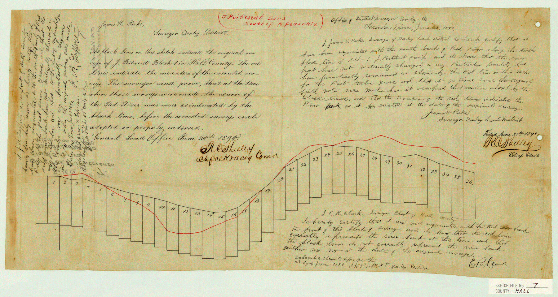
Hall County Sketch File 7
Clark's sk. of J. Poitevent's Block S of river
-
Map/Doc
11603
-
Collection
General Map Collection
-
Object Dates
1890/6/20 (Creation Date)
1890/6/25 (File Date)
-
People and Organizations
Clark (Surveyor/Engineer)
R.C. Shelley (GLO Clerk)
James H. Parks (Surveyor/Engineer)
-
Counties
Hall
-
Subjects
Surveying Sketch File
-
Height x Width
12.0 x 22.4 inches
30.5 x 56.9 cm
-
Medium
paper, manuscript
-
Features
Red River
Part of: General Map Collection
Aransas County Aerial Photograph Index Sheet 2

Print $20.00
- Digital $50.00
Aransas County Aerial Photograph Index Sheet 2
1957
Size 23.0 x 17.9 inches
Map/Doc 83660
Flight Mission No. DQN-3K, Frame 11, Calhoun County

Print $20.00
- Digital $50.00
Flight Mission No. DQN-3K, Frame 11, Calhoun County
1953
Size 18.6 x 22.2 inches
Map/Doc 84343
Gregg County Boundary File 3

Print $8.00
- Digital $50.00
Gregg County Boundary File 3
Size 14.1 x 8.5 inches
Map/Doc 53988
Frio County Rolled Sketch 7

Print $20.00
- Digital $50.00
Frio County Rolled Sketch 7
Size 21.0 x 17.4 inches
Map/Doc 5918
Angelina County Sketch File 23a

Print $4.00
- Digital $50.00
Angelina County Sketch File 23a
1904
Size 11.2 x 8.6 inches
Map/Doc 13063
Starr County Rolled Sketch X

Print $121.00
- Digital $50.00
Starr County Rolled Sketch X
Size 13.3 x 8.1 inches
Map/Doc 75961
Navigation Maps of Gulf Intracoastal Waterway, Port Arthur to Brownsville, Texas

Print $4.00
- Digital $50.00
Navigation Maps of Gulf Intracoastal Waterway, Port Arthur to Brownsville, Texas
1951
Size 16.7 x 21.6 inches
Map/Doc 65426
Padre Island National Seashore, Texas - Dependent Resurvey

Print $4.00
- Digital $50.00
Padre Island National Seashore, Texas - Dependent Resurvey
2001
Size 18.3 x 24.2 inches
Map/Doc 60546

Upton County Rolled Sketch 50

Print $20.00
- Digital $50.00
Upton County Rolled Sketch 50
1959
Size 20.8 x 32.7 inches
Map/Doc 8085
Ramon de la Garza 11 Leagues Houston and Robertson Districts

Print $2.00
- Digital $50.00
Ramon de la Garza 11 Leagues Houston and Robertson Districts
Size 11.5 x 8.5 inches
Map/Doc 181
Flight Mission No. DAG-17K, Frame 124, Matagorda County

Print $20.00
- Digital $50.00
Flight Mission No. DAG-17K, Frame 124, Matagorda County
1952
Size 18.6 x 22.3 inches
Map/Doc 86344
You may also like
Brewster County Sketch File N-12

Print $4.00
- Digital $50.00
Brewster County Sketch File N-12
1933
Size 14.3 x 9.0 inches
Map/Doc 15623
McMullen County Working Sketch 39

Print $40.00
- Digital $50.00
McMullen County Working Sketch 39
1975
Size 53.3 x 31.7 inches
Map/Doc 70740

Wendlandt's Subdivision of part of Outlot 4, Division "Z"

Print $20.00
- Digital $50.00
Wendlandt's Subdivision of part of Outlot 4, Division "Z"
1910
Size 17.9 x 13.5 inches
Map/Doc 5041
Map of Cherokee County

Print $40.00
- Digital $50.00
Map of Cherokee County
1933
Size 55.0 x 38.7 inches
Map/Doc 95453
Hockley County Rolled Sketch 4

Print $40.00
- Digital $50.00
Hockley County Rolled Sketch 4
Size 40.5 x 54.7 inches
Map/Doc 9174
Kent County Working Sketch 11

Print $20.00
- Digital $50.00
Kent County Working Sketch 11
Size 24.3 x 37.4 inches
Map/Doc 70018
Part of Laguna Madre from Mosquito Trangulation Station to Sand Triangulation Station

Print $40.00
- Digital $50.00
Part of Laguna Madre from Mosquito Trangulation Station to Sand Triangulation Station
1881
Size 34.5 x 54.6 inches
Map/Doc 73486

Concho County Rolled Sketch 14

Print $20.00
- Digital $50.00
Concho County Rolled Sketch 14
1959
Size 29.9 x 31.2 inches
Map/Doc 8659
General Highway Map, Dawson County, Texas

Print $20.00
General Highway Map, Dawson County, Texas
1940
Size 18.5 x 25.2 inches
Map/Doc 79071
General Highway Map, Denton County, Texas

Print $20.00
General Highway Map, Denton County, Texas
1961
Size 18.2 x 24.5 inches
Map/Doc 79441