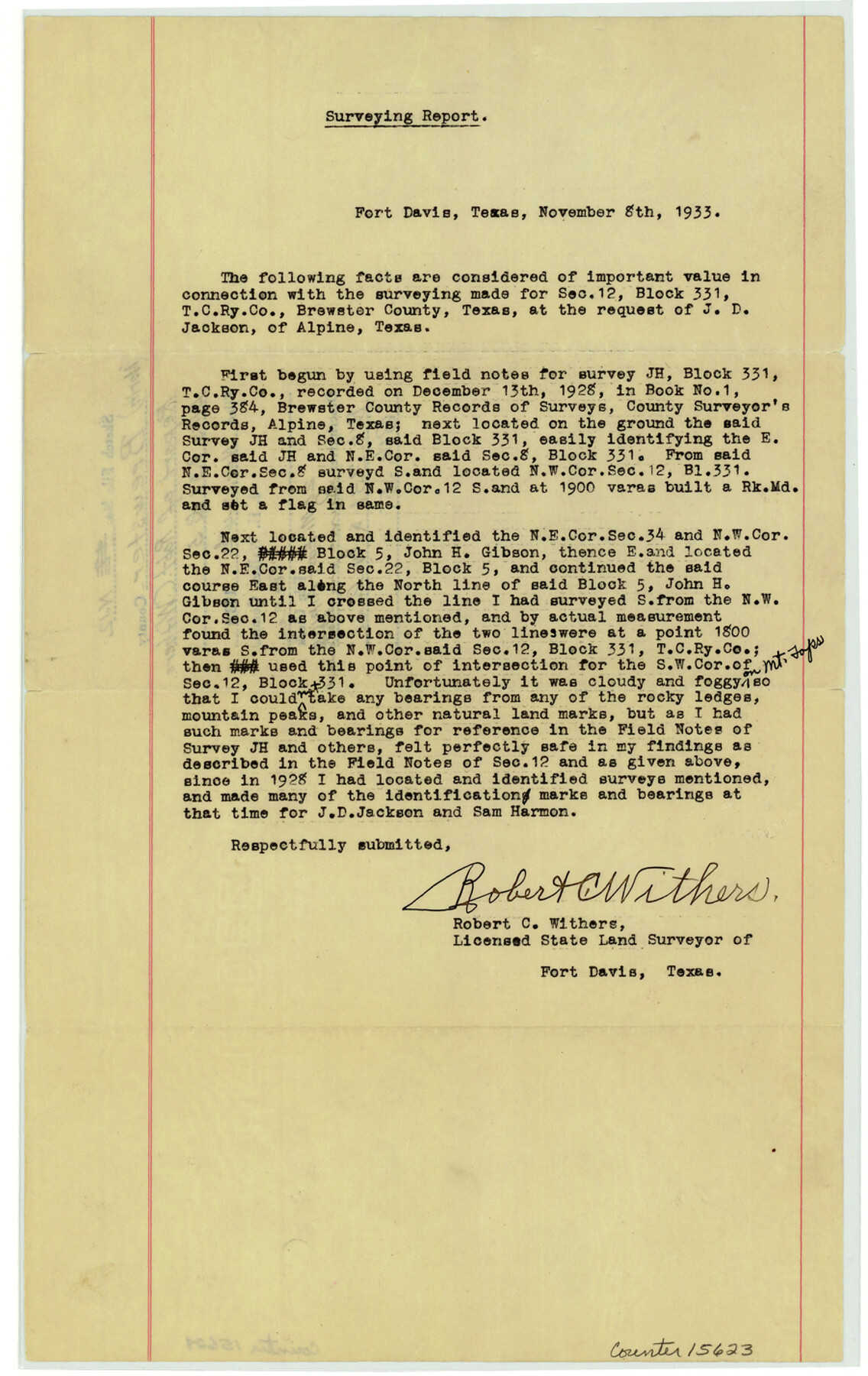
Brewster County Sketch File N-12
[Report on Block 331 and north line of Block 5]
-
Map/Doc
15623
-
Collection
General Map Collection
-
Object Dates
1933/11/8 (Creation Date)
1933/11/24 (File Date)
-
People and Organizations
Robert C. Withers (Surveyor/Engineer)
-
Counties
Brewster
-
Subjects
Surveying Sketch File
-
Height x Width
14.3 x 9.0 inches
36.3 x 22.9 cm
-
Medium
paper, print
Part of: General Map Collection
McMullen County Working Sketch 39

Print $40.00
- Digital $50.00
McMullen County Working Sketch 39
1975
Size 53.3 x 31.7 inches
Map/Doc 70740
Erath County Working Sketch 16

Print $20.00
- Digital $50.00
Erath County Working Sketch 16
1961
Size 20.9 x 26.5 inches
Map/Doc 69097
Val Verde County Rolled Sketch 38

Print $20.00
- Digital $50.00
Val Verde County Rolled Sketch 38
Size 30.4 x 19.5 inches
Map/Doc 61781
Travis County Rolled Sketch 47

Print $40.00
- Digital $50.00
Travis County Rolled Sketch 47
1923
Size 57.3 x 26.5 inches
Map/Doc 10626
Culberson County Working Sketch 72

Print $40.00
- Digital $50.00
Culberson County Working Sketch 72
1975
Size 50.1 x 34.2 inches
Map/Doc 68526
Tom Green County Boundary File 7

Print $10.00
- Digital $50.00
Tom Green County Boundary File 7
Size 14.5 x 9.2 inches
Map/Doc 59388

Lampasas County Boundary File 15a

Print $33.00
- Digital $50.00
Lampasas County Boundary File 15a
Size 13.3 x 8.2 inches
Map/Doc 56210
Edwards County Rolled Sketch 30

Print $20.00
- Digital $50.00
Edwards County Rolled Sketch 30
1980
Size 31.6 x 44.0 inches
Map/Doc 8848
Bosque County Sketch File 34

Print $20.00
- Digital $50.00
Bosque County Sketch File 34
1856
Size 25.2 x 18.7 inches
Map/Doc 78486
Uvalde County

Print $20.00
- Digital $50.00
Uvalde County
1915
Size 46.0 x 46.0 inches
Map/Doc 16910

You may also like
Official Map City of Lubbock Lubbock County, Texas

Print $20.00
- Digital $50.00
Official Map City of Lubbock Lubbock County, Texas
1927
Size 44.6 x 33.4 inches
Map/Doc 93220

Duval County Sketch File 87

Print $12.00
- Digital $50.00
Duval County Sketch File 87
1991
Size 11.0 x 8.5 inches
Map/Doc 21549
Hays County Sketch File 12

Print $4.00
- Digital $50.00
Hays County Sketch File 12
1866
Size 8.5 x 7.2 inches
Map/Doc 26218
Gulf Oil Corp. Fishgide - Freeport

Gulf Oil Corp. Fishgide - Freeport
1960
Size 12.1 x 22.1 inches
Map/Doc 75979
Hall County Sketch File 28

Print $20.00
- Digital $50.00
Hall County Sketch File 28
1913
Size 18.0 x 21.5 inches
Map/Doc 11611
Northwest Part of Webb County

Print $40.00
- Digital $50.00
Northwest Part of Webb County
1984
Size 42.0 x 50.2 inches
Map/Doc 77454
Dimmit County Sketch File 38

Print $40.00
- Digital $50.00
Dimmit County Sketch File 38
1896
Size 14.8 x 16.9 inches
Map/Doc 21163
Map of Dalhart, Dallam & Hartley Co's, Texas

Print $20.00
- Digital $50.00
Map of Dalhart, Dallam & Hartley Co's, Texas
Size 22.7 x 35.2 inches
Map/Doc 92125
Flight Mission No. BRA-6M, Frame 146, Jefferson County

Print $20.00
- Digital $50.00
Flight Mission No. BRA-6M, Frame 146, Jefferson County
1953
Size 18.6 x 22.3 inches
Map/Doc 85447
Van Zandt County Rolled Sketch 6

Print $6.00
- Digital $50.00
Van Zandt County Rolled Sketch 6
1946
Size 33.5 x 34.2 inches
Map/Doc 10091
Val Verde County Sketch File 41

Print $20.00
- Digital $50.00
Val Verde County Sketch File 41
1938
Size 17.8 x 22.7 inches
Map/Doc 12583