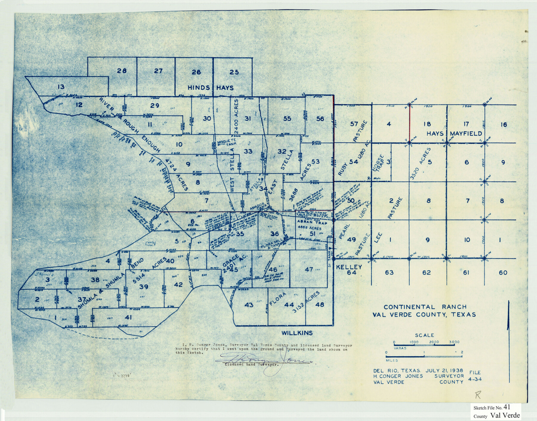
Val Verde County Sketch File 41
[Sketch of Block EG and surrounding area, known as Continental Ranch]
-
Map/Doc
12583
-
Collection
General Map Collection
-
Object Dates
7/21/1938 (Creation Date)
6/5/1939 (File Date)
-
People and Organizations
H. Conger Jones (Surveyor/Engineer)
-
Counties
Val Verde
-
Subjects
Cadastral Surveying Sketch File
-
Height x Width
17.8 x 22.7 inches
45.2 x 57.7 cm
-
Medium
blueprint/diazo
Part of: General Map Collection
Trinity River, Boyd Crossing Sheet/Chambers Creek
![65238, Trinity River, Boyd Crossing Sheet/Chambers Creek, General Map Collection](https://historictexasmaps.com/wmedia_w700/maps/65238.tif.jpg)
Print $20.00
- Digital $50.00
Trinity River, Boyd Crossing Sheet/Chambers Creek
1931
Size 17.5 x 43.1 inches
Map/Doc 65238
San Patricio County Rolled Sketch 50
![7736, San Patricio County Rolled Sketch 50, General Map Collection](https://historictexasmaps.com/wmedia_w700/maps/7736.tif.jpg)
Print $29.00
- Digital $50.00
San Patricio County Rolled Sketch 50
1988
Size 18.2 x 23.5 inches
Map/Doc 7736
San Augustine County Rolled Sketch 3
![7555, San Augustine County Rolled Sketch 3, General Map Collection](https://historictexasmaps.com/wmedia_w700/maps/7555.tif.jpg)
Print $20.00
- Digital $50.00
San Augustine County Rolled Sketch 3
1969
Size 21.5 x 29.0 inches
Map/Doc 7555
Zavala County Sketch File 4
![12726, Zavala County Sketch File 4, General Map Collection](https://historictexasmaps.com/wmedia_w700/pdf_converted_jpg/qi_pdf_thumbnail_8986.jpg)
Print $20.00
- Digital $50.00
Zavala County Sketch File 4
1852
Size 17.7 x 14.7 inches
Map/Doc 12726
Red River County Working Sketch 44
![72027, Red River County Working Sketch 44, General Map Collection](https://historictexasmaps.com/wmedia_w700/maps/72027.tif.jpg)
Print $4.00
- Digital $50.00
Red River County Working Sketch 44
Size 28.1 x 28.3 inches
Map/Doc 72027
Current Miscellaneous File 120
![88754, Current Miscellaneous File 120, General Map Collection](https://historictexasmaps.com/wmedia_w700/pdf_converted_jpg/qi_pdf_thumbnail_34389.jpg)
Print $14.00
- Digital $50.00
Current Miscellaneous File 120
Size 8.5 x 11.0 inches
Map/Doc 88754
Jim Hogg County Sketch File 8
![11887, Jim Hogg County Sketch File 8, General Map Collection](https://historictexasmaps.com/wmedia_w700/pdf_converted_jpg/qi_pdf_thumbnail_8276.jpg)
Print $20.00
- Digital $50.00
Jim Hogg County Sketch File 8
1941
Size 21.9 x 27.0 inches
Map/Doc 11887
Harrison County Boundary File 41 (10)
![54418, Harrison County Boundary File 41 (10), General Map Collection](https://historictexasmaps.com/wmedia_w700/pdf_converted_jpg/qi_pdf_thumbnail_16181.jpg)
Print $10.00
- Digital $50.00
Harrison County Boundary File 41 (10)
Size 7.1 x 3.4 inches
Map/Doc 54418
Karnes County Boundary File 2
![55686, Karnes County Boundary File 2, General Map Collection](https://historictexasmaps.com/wmedia_w700/pdf_converted_jpg/qi_pdf_thumbnail_16322.jpg)
Print $12.00
- Digital $50.00
Karnes County Boundary File 2
Size 14.1 x 8.7 inches
Map/Doc 55686
Brewster County Rolled Sketch 29
![5216, Brewster County Rolled Sketch 29, General Map Collection](https://historictexasmaps.com/wmedia_w700/maps/5216.tif.jpg)
Print $20.00
- Digital $50.00
Brewster County Rolled Sketch 29
1910
Size 17.5 x 18.5 inches
Map/Doc 5216
Calhoun County Rolled Sketch 20
![5372, Calhoun County Rolled Sketch 20, General Map Collection](https://historictexasmaps.com/wmedia_w700/maps/5372.tif.jpg)
Print $20.00
- Digital $50.00
Calhoun County Rolled Sketch 20
1959
Size 36.9 x 20.7 inches
Map/Doc 5372
Parker County Sketch File 33
![33576, Parker County Sketch File 33, General Map Collection](https://historictexasmaps.com/wmedia_w700/pdf_converted_jpg/qi_pdf_thumbnail_13527.jpg)
Print $4.00
- Digital $50.00
Parker County Sketch File 33
Size 10.6 x 7.9 inches
Map/Doc 33576
You may also like
Acts of the Visit of the Royal Commissioners (sometimes referred to as the “Visita General”) - Mier
![94257, Acts of the Visit of the Royal Commissioners (sometimes referred to as the “Visita General”) - Mier, Historical Volumes](https://historictexasmaps.com/wmedia_w700/pdf_converted_jpg/qi_pdf_thumbnail_38898.jpg)
Acts of the Visit of the Royal Commissioners (sometimes referred to as the “Visita General”) - Mier
1767
Size 14.0 x 9.2 inches
Map/Doc 94257
A Sketch of the Vice Royalty exhibiting the several Provinces and its Aproximation [sic] to the Internal Provinces of New Spain
![95157, A Sketch of the Vice Royalty exhibiting the several Provinces and its Aproximation [sic] to the Internal Provinces of New Spain, General Map Collection](https://historictexasmaps.com/wmedia_w700/maps/95157.tif.jpg)
Print $20.00
- Digital $50.00
A Sketch of the Vice Royalty exhibiting the several Provinces and its Aproximation [sic] to the Internal Provinces of New Spain
1810
Size 15.2 x 21.1 inches
Map/Doc 95157
McMullen County Sketch File 24
![31381, McMullen County Sketch File 24, General Map Collection](https://historictexasmaps.com/wmedia_w700/pdf_converted_jpg/qi_pdf_thumbnail_13025.jpg)
Print $22.00
- Digital $50.00
McMullen County Sketch File 24
Size 8.7 x 12.6 inches
Map/Doc 31381
Ward County Working Sketch 47
![72353, Ward County Working Sketch 47, General Map Collection](https://historictexasmaps.com/wmedia_w700/maps/72353.tif.jpg)
Print $20.00
- Digital $50.00
Ward County Working Sketch 47
Size 41.3 x 33.9 inches
Map/Doc 72353
[G. C. & S. F. Ry. Co. Block H, E. L. & R. R. Ry. Co. Block D7 and vicinity]
![91864, [G. C. & S. F. Ry. Co. Block H, E. L. & R. R. Ry. Co. Block D7 and vicinity], Twichell Survey Records](https://historictexasmaps.com/wmedia_w700/maps/91864-1.tif.jpg)
Print $20.00
- Digital $50.00
[G. C. & S. F. Ry. Co. Block H, E. L. & R. R. Ry. Co. Block D7 and vicinity]
Size 15.0 x 18.5 inches
Map/Doc 91864
Shelby County Working Sketch 35
![89285, Shelby County Working Sketch 35, General Map Collection](https://historictexasmaps.com/wmedia_w700/maps/89285.tif.jpg)
Print $20.00
- Digital $50.00
Shelby County Working Sketch 35
2010
Size 27.4 x 28.3 inches
Map/Doc 89285
Pecos County Boundary File 69a
![57901, Pecos County Boundary File 69a, General Map Collection](https://historictexasmaps.com/wmedia_w700/pdf_converted_jpg/qi_pdf_thumbnail_16667.jpg)
Print $40.00
- Digital $50.00
Pecos County Boundary File 69a
Size 8.4 x 9.7 inches
Map/Doc 57901
The Judicial District/County of Guadalupe. Abolished, Spring 1842
![96328, The Judicial District/County of Guadalupe. Abolished, Spring 1842, Nancy and Jim Tiller Digital Collection](https://historictexasmaps.com/wmedia_w700/maps/96328.tif.jpg)
Print $20.00
- Digital $50.00
The Judicial District/County of Guadalupe. Abolished, Spring 1842
2020
Size 8.3 x 10.8 inches
Map/Doc 96328
Real County Working Sketch 10
![71902, Real County Working Sketch 10, General Map Collection](https://historictexasmaps.com/wmedia_w700/maps/71902.tif.jpg)
Print $20.00
- Digital $50.00
Real County Working Sketch 10
Size 23.0 x 15.4 inches
Map/Doc 71902
Map of Childress, Childress County, Texas on the Line of the Fort Worth and Denver City Railway, Texas Pan-Handle Route
![7691, Map of Childress, Childress County, Texas on the Line of the Fort Worth and Denver City Railway, Texas Pan-Handle Route, General Map Collection](https://historictexasmaps.com/wmedia_w700/maps/07691.tif.jpg)
Print $20.00
- Digital $50.00
Map of Childress, Childress County, Texas on the Line of the Fort Worth and Denver City Railway, Texas Pan-Handle Route
1888
Size 35.6 x 28.0 inches
Map/Doc 7691
Harris County Sketch File 9
![25340, Harris County Sketch File 9, General Map Collection](https://historictexasmaps.com/wmedia_w700/pdf_converted_jpg/qi_pdf_thumbnail_11712.jpg)
Print $4.00
- Digital $50.00
Harris County Sketch File 9
1861
Size 6.7 x 7.3 inches
Map/Doc 25340
Jasper County Working Sketch 33
![66495, Jasper County Working Sketch 33, General Map Collection](https://historictexasmaps.com/wmedia_w700/maps/66495.tif.jpg)
Print $6.00
- Digital $50.00
Jasper County Working Sketch 33
Size 30.4 x 17.5 inches
Map/Doc 66495