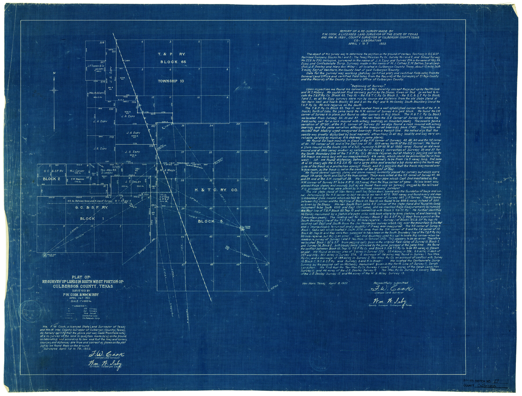
Culberson County Rolled Sketch 27
Plat of resurvey of lands in southwest portion of Culberson County, Texas
-
Map/Doc
5656
-
Collection
General Map Collection
-
Object Dates
4/8/1922 (Creation Date)
9/2/1922 (File Date)
4/7/1922 (Survey Date)
-
People and Organizations
Wm. W. Irby (Surveyor/Engineer)
F.W. Cook (Surveyor/Engineer)
-
Counties
Culberson
-
Subjects
Surveying Rolled Sketch
-
Height x Width
26.8 x 34.9 inches
68.1 x 88.7 cm
-
Medium
blueprint/diazo
-
Scale
1" = 1000 varas
Part of: General Map Collection
Greer County Sketch File 8

Print $20.00
- Digital $50.00
Greer County Sketch File 8
Size 16.7 x 23.6 inches
Map/Doc 11584
Hardin County Sketch File 24b

Print $4.00
- Digital $50.00
Hardin County Sketch File 24b
Size 6.4 x 8.0 inches
Map/Doc 25146
Strip Map of Texas-Oklahoma Boundary from Denison East to the Oklahoma-Arkansas State Line

Print $20.00
- Digital $50.00
Strip Map of Texas-Oklahoma Boundary from Denison East to the Oklahoma-Arkansas State Line
1933
Size 37.7 x 24.5 inches
Map/Doc 75927
Midland County Working Sketch 28

Print $20.00
- Digital $50.00
Midland County Working Sketch 28
1968
Size 29.7 x 31.7 inches
Map/Doc 71009
Flight Mission No. DCL-4C, Frame 148, Kenedy County

Print $20.00
- Digital $50.00
Flight Mission No. DCL-4C, Frame 148, Kenedy County
1943
Size 18.6 x 22.5 inches
Map/Doc 85826
Hardin County Sketch File 35

Print $24.00
- Digital $50.00
Hardin County Sketch File 35
Size 9.2 x 8.4 inches
Map/Doc 25175
Map of Parker County

Print $20.00
- Digital $50.00
Map of Parker County
1860
Size 24.1 x 19.0 inches
Map/Doc 3945

Bosque County Sketch File 3

Print $40.00
- Digital $50.00
Bosque County Sketch File 3
1848
Size 16.1 x 12.4 inches
Map/Doc 14742
Military Reconnaissance [showing forts along Rio Grande near Matamoros]
![72912, Military Reconnaissance [showing forts along Rio Grande near Matamoros], General Map Collection](https://historictexasmaps.com/wmedia_w700/maps/72912.tif.jpg)
Print $20.00
- Digital $50.00
Military Reconnaissance [showing forts along Rio Grande near Matamoros]
1846
Size 18.3 x 27.0 inches
Map/Doc 72912
Hudspeth County Rolled Sketch 32

Print $40.00
- Digital $50.00
Hudspeth County Rolled Sketch 32
Size 32.7 x 94.9 inches
Map/Doc 9211
Milam County Rolled Sketch 3C

Print $20.00
- Digital $50.00
Milam County Rolled Sketch 3C
1959
Size 21.8 x 18.4 inches
Map/Doc 6776
You may also like
Mason County Working Sketch 13

Print $20.00
- Digital $50.00
Mason County Working Sketch 13
1954
Size 20.0 x 29.9 inches
Map/Doc 70849
Wichita County Sketch File 27

Print $52.00
- Digital $50.00
Wichita County Sketch File 27
1925
Size 9.1 x 7.9 inches
Map/Doc 40114
Roberts County Rolled Sketch 3

Print $40.00
- Digital $50.00
Roberts County Rolled Sketch 3
Size 38.0 x 49.7 inches
Map/Doc 8355
Red River County Working Sketch 81-3

Print $20.00
- Digital $50.00
Red River County Working Sketch 81-3
1987
Size 17.5 x 21.5 inches
Map/Doc 72066

Schleicher County Sketch File 38

Print $20.00
- Digital $50.00
Schleicher County Sketch File 38
Size 19.1 x 21.7 inches
Map/Doc 12311
Menard County Sketch File 12

Print $12.00
- Digital $50.00
Menard County Sketch File 12
1892
Size 11.1 x 8.2 inches
Map/Doc 31500
Val Verde County Rolled Sketch 45

Print $20.00
- Digital $50.00
Val Verde County Rolled Sketch 45
Size 20.8 x 23.1 inches
Map/Doc 8118
General Highway Map. Detail of Cities and Towns in Jefferson County, Texas [Beaumont-Port Arthur vicinity]
![79145, General Highway Map. Detail of Cities and Towns in Jefferson County, Texas [Beaumont-Port Arthur vicinity], Texas State Library and Archives](https://historictexasmaps.com/wmedia_w700/maps/79145.tif.jpg)
Print $20.00
General Highway Map. Detail of Cities and Towns in Jefferson County, Texas [Beaumont-Port Arthur vicinity]
1940
Size 24.8 x 18.3 inches
Map/Doc 79145
General Highway Map, Castro County, Texas

Print $20.00
General Highway Map, Castro County, Texas
1961
Size 18.2 x 24.7 inches
Map/Doc 79403

Flight Mission No. CUG-3P, Frame 15, Kleberg County

Print $20.00
- Digital $50.00
Flight Mission No. CUG-3P, Frame 15, Kleberg County
1956
Size 18.8 x 22.4 inches
Map/Doc 86225