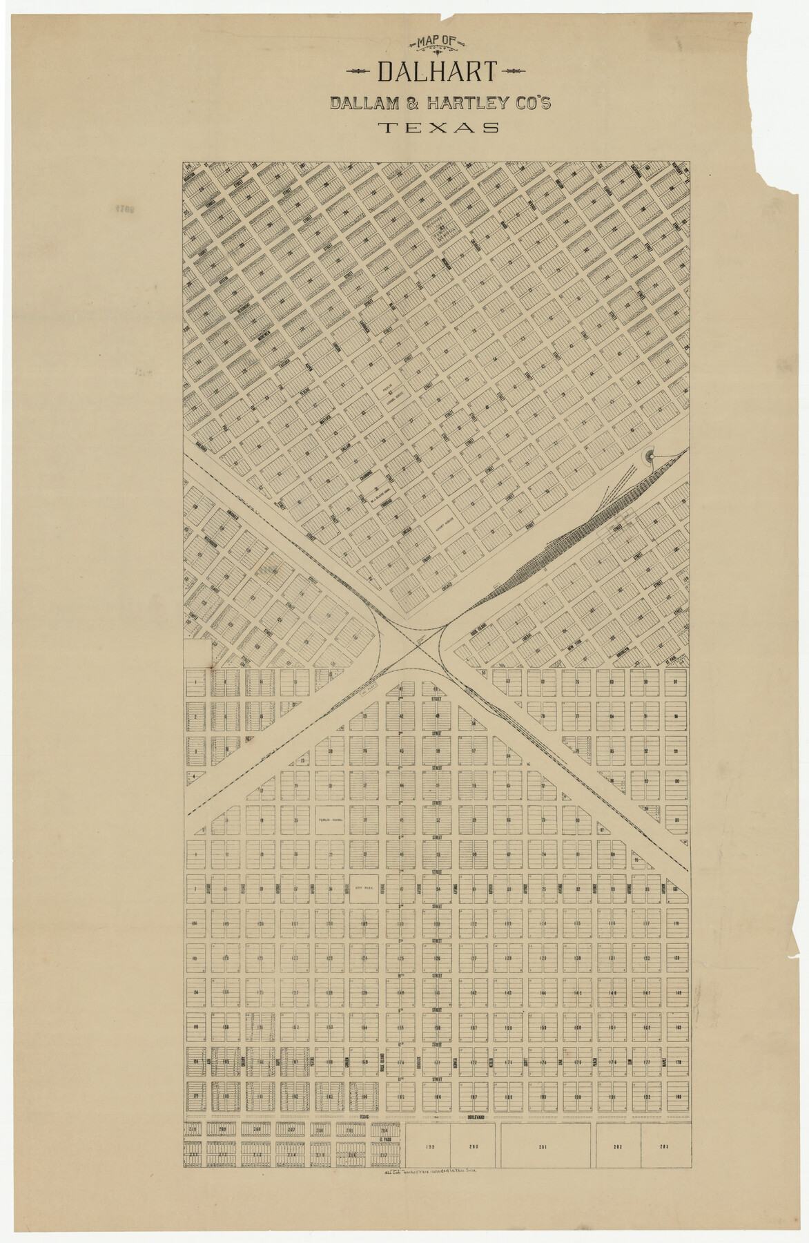
Map of Dalhart, Dallam & Hartley Co's, Texas
-
Map/Doc
92125
-
Collection
Twichell Survey Records
-
Counties
Dallam Hartley
-
Height x Width
22.7 x 35.2 inches
57.7 x 89.4 cm
Part of: Twichell Survey Records
[Sketch showing part of H. & G. N. Block 1]
![89633, [Sketch showing part of H. & G. N. Block 1], Twichell Survey Records](https://historictexasmaps.com/wmedia_w700/maps/89633-1.tif.jpg)
Print $40.00
- Digital $50.00
[Sketch showing part of H. & G. N. Block 1]
Size 20.0 x 54.4 inches
Map/Doc 89633
McMullen County

Print $20.00
- Digital $50.00
McMullen County
1889
Size 12.4 x 16.4 inches
Map/Doc 92957
W. L. Ellwood's O Ranch, Lubbock and Hockley Co.

Print $20.00
- Digital $50.00
W. L. Ellwood's O Ranch, Lubbock and Hockley Co.
Size 15.5 x 23.8 inches
Map/Doc 92762
[Surveys on the south side of the Canadian River]
![91788, [Surveys on the south side of the Canadian River], Twichell Survey Records](https://historictexasmaps.com/wmedia_w700/maps/91788-1.tif.jpg)
Print $3.00
- Digital $50.00
[Surveys on the south side of the Canadian River]
Size 11.2 x 15.9 inches
Map/Doc 91788
[Blocks C31, C32, C36-C38 and C41-C42]
![91935, [Blocks C31, C32, C36-C38 and C41-C42], Twichell Survey Records](https://historictexasmaps.com/wmedia_w700/maps/91935-1.tif.jpg)
Print $20.00
- Digital $50.00
[Blocks C31, C32, C36-C38 and C41-C42]
Size 27.9 x 23.1 inches
Map/Doc 91935
[Worksheets related to the Wilson Strickland survey and vicinity]
![91282, [Worksheets related to the Wilson Strickland survey and vicinity], Twichell Survey Records](https://historictexasmaps.com/wmedia_w700/maps/91282-1.tif.jpg)
Print $20.00
- Digital $50.00
[Worksheets related to the Wilson Strickland survey and vicinity]
Size 7.9 x 24.3 inches
Map/Doc 91282
[Blocks Surrounding I. G. Yates Section 34 1/2]
![92442, [Blocks Surrounding I. G. Yates Section 34 1/2], Twichell Survey Records](https://historictexasmaps.com/wmedia_w700/maps/92442-1.tif.jpg)
Print $20.00
- Digital $50.00
[Blocks Surrounding I. G. Yates Section 34 1/2]
Size 41.9 x 11.3 inches
Map/Doc 92442
[Sketch showing west part of county]
![91713, [Sketch showing west part of county], Twichell Survey Records](https://historictexasmaps.com/wmedia_w700/maps/91713-1.tif.jpg)
Print $20.00
- Digital $50.00
[Sketch showing west part of county]
Size 24.2 x 13.8 inches
Map/Doc 91713
Capitol Syndicate Subdivision of Capitol Land Reservation Leagues

Print $20.00
- Digital $50.00
Capitol Syndicate Subdivision of Capitol Land Reservation Leagues
1908
Size 25.6 x 31.5 inches
Map/Doc 92584
Sketch showing recent surveys of State School Land adjoining Capitol Leagues No. 357 1/2, 367, 373 and 374 corrected out of conflict

Print $2.00
- Digital $50.00
Sketch showing recent surveys of State School Land adjoining Capitol Leagues No. 357 1/2, 367, 373 and 374 corrected out of conflict
1905
Size 7.3 x 10.4 inches
Map/Doc 90535
[East Portion of Lea County] / [Central part of San Miguel County, New Mexico]
![92033, [East Portion of Lea County] / [Central part of San Miguel County, New Mexico], Twichell Survey Records](https://historictexasmaps.com/wmedia_w700/maps/92033-1.tif.jpg)
Print $20.00
- Digital $50.00
[East Portion of Lea County] / [Central part of San Miguel County, New Mexico]
Size 26.9 x 13.9 inches
Map/Doc 92033
[Sketch showing G. H.& H. Ry. Co. Blks. 2 and 3, H. & T. C. Ry. Co. Blk. 45 and T. &N. O. Ry. Co. Blk. 5T]
![89679, [Sketch showing G. H.& H. Ry. Co. Blks. 2 and 3, H. & T. C. Ry. Co. Blk. 45 and T. &N. O. Ry. Co. Blk. 5T], Twichell Survey Records](https://historictexasmaps.com/wmedia_w700/maps/89679-1.tif.jpg)
Print $20.00
- Digital $50.00
[Sketch showing G. H.& H. Ry. Co. Blks. 2 and 3, H. & T. C. Ry. Co. Blk. 45 and T. &N. O. Ry. Co. Blk. 5T]
1890
Size 23.6 x 36.8 inches
Map/Doc 89679
You may also like
Archer County

Print $20.00
- Digital $50.00
Archer County
1898
Size 36.0 x 39.4 inches
Map/Doc 93033
Copy of Surveyor's Field Book, Morris Browning - In Blocks 7, 5 & 4, I&GNRRCo., Hutchinson and Carson Counties, Texas

Print $2.00
- Digital $50.00
Copy of Surveyor's Field Book, Morris Browning - In Blocks 7, 5 & 4, I&GNRRCo., Hutchinson and Carson Counties, Texas
1888
Size 6.9 x 8.8 inches
Map/Doc 62271
Brewster County Rolled Sketch 15

Print $20.00
- Digital $50.00
Brewster County Rolled Sketch 15
1889
Size 32.8 x 26.4 inches
Map/Doc 5194
Asher and Adams' Texas - Western Portion

Print $20.00
- Digital $50.00
Asher and Adams' Texas - Western Portion
1874
Size 24.6 x 18.1 inches
Map/Doc 93787
Matagorda County Sketch File 15

Print $48.00
- Digital $50.00
Matagorda County Sketch File 15
Size 8.7 x 11.2 inches
Map/Doc 30774
Robertson Co.

Print $20.00
- Digital $50.00
Robertson Co.
1945
Size 46.3 x 37.2 inches
Map/Doc 77409
Brown County Working Sketch 16

Print $20.00
- Digital $50.00
Brown County Working Sketch 16
1993
Size 46.3 x 34.7 inches
Map/Doc 67781
Baylor County Sketch File 11A

Print $40.00
- Digital $50.00
Baylor County Sketch File 11A
Size 33.9 x 32.0 inches
Map/Doc 10322
Geographically Correct Map of United States showing the Union Pacific System - Union Pacific R.R. Co., Oregon Short Line R.R. Co., Oregon-Washington R.R. & Nav. Co., Los Angeles & Salt Lake R.R. Co., St. Joseph & Grand Island Ry. Co. and connections

Print $20.00
- Digital $50.00
Geographically Correct Map of United States showing the Union Pacific System - Union Pacific R.R. Co., Oregon Short Line R.R. Co., Oregon-Washington R.R. & Nav. Co., Los Angeles & Salt Lake R.R. Co., St. Joseph & Grand Island Ry. Co. and connections
1922
Size 18.2 x 32.2 inches
Map/Doc 95771
Brazoria County Working Sketch 14

Print $20.00
- Digital $50.00
Brazoria County Working Sketch 14
1940
Size 33.6 x 43.9 inches
Map/Doc 67499
Medina County Sketch File 11

Print $14.00
- Digital $50.00
Medina County Sketch File 11
1907
Size 10.4 x 6.6 inches
Map/Doc 31461
Motley County Sketch File 7a (S)

Print $5.00
- Digital $50.00
Motley County Sketch File 7a (S)
1895
Size 9.6 x 8.8 inches
Map/Doc 32151