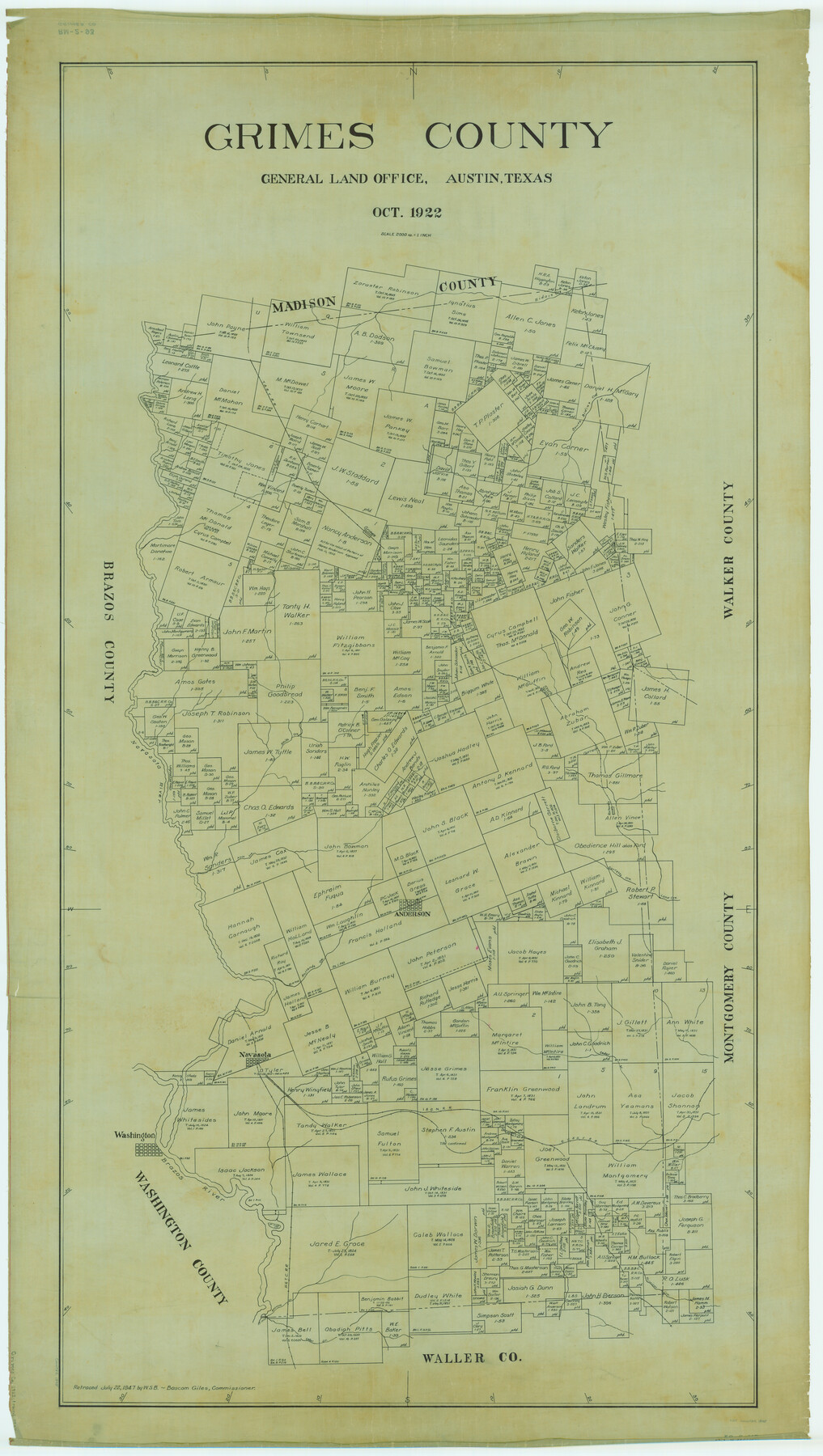
Grimes County
RM-2-93
-
Map/Doc
1845
-
Collection
General Map Collection
-
Object Dates
1922 (Creation Date)
-
People and Organizations
Texas General Land Office (Publisher)
Bascom Giles (GLO Commissioner)
-
Counties
Grimes
-
Subjects
County
-
Height x Width
58.1 x 32.8 inches
147.6 x 83.3 cm
-
Comments
Retraced July 22, 1947 by W. S. B.
Part of: General Map Collection
Nueces County NRC Article 33.136 Location Key Sheet

Print $20.00
- Digital $50.00
Nueces County NRC Article 33.136 Location Key Sheet
1975
Size 27.0 x 23.0 inches
Map/Doc 77032
Orange County Sketch File 43

Print $4.00
- Digital $50.00
Orange County Sketch File 43
1873
Size 8.2 x 10.3 inches
Map/Doc 33385
Leon County Sketch File 38

Print $10.00
- Digital $50.00
Leon County Sketch File 38
1999
Size 11.0 x 8.5 inches
Map/Doc 29878
Map of Marion County

Print $20.00
- Digital $50.00
Map of Marion County
1920
Size 29.2 x 42.2 inches
Map/Doc 78405
Crockett County Sketch File 43

Print $20.00
- Digital $50.00
Crockett County Sketch File 43
1880
Size 17.9 x 23.8 inches
Map/Doc 11223
Maps of Gulf Intracoastal Waterway, Texas - Sabine River to the Rio Grande and connecting waterways including ship channels

Print $20.00
- Digital $50.00
Maps of Gulf Intracoastal Waterway, Texas - Sabine River to the Rio Grande and connecting waterways including ship channels
1966
Size 15.7 x 22.0 inches
Map/Doc 61983
San Antonio & Aransas Pass RR Co., Fort Bend County, Texas

Print $20.00
- Digital $50.00
San Antonio & Aransas Pass RR Co., Fort Bend County, Texas
1898
Size 10.5 x 31.0 inches
Map/Doc 64143
Right of Way and Track Map, International & Gt. Northern Ry. operated by the International & Gt. Northern Ry. Co. Gulf Division, Mineola Branch

Print $40.00
- Digital $50.00
Right of Way and Track Map, International & Gt. Northern Ry. operated by the International & Gt. Northern Ry. Co. Gulf Division, Mineola Branch
1917
Size 25.4 x 121.1 inches
Map/Doc 64702
Pecos County Rolled Sketch 51

Print $20.00
- Digital $50.00
Pecos County Rolled Sketch 51
1914
Size 8.6 x 35.5 inches
Map/Doc 7227
Flight Mission No. CRC-3R, Frame 37, Chambers County

Print $20.00
- Digital $50.00
Flight Mission No. CRC-3R, Frame 37, Chambers County
1956
Size 18.6 x 22.4 inches
Map/Doc 84810
Hidalgo County Sketch File 12

Print $20.00
- Digital $50.00
Hidalgo County Sketch File 12
Size 16.3 x 25.1 inches
Map/Doc 11763
Flight Mission No. DQN-1K, Frame 30, Calhoun County

Print $20.00
- Digital $50.00
Flight Mission No. DQN-1K, Frame 30, Calhoun County
1953
Size 18.6 x 22.2 inches
Map/Doc 84135
You may also like
[Sketch for Mineral Application 11318 - Arenosa Creek, S. G. Drushel]
![65648, [Sketch for Mineral Application 11318 - Arenosa Creek, S. G. Drushel], General Map Collection](https://historictexasmaps.com/wmedia_w700/maps/65648-1.tif.jpg)
Print $40.00
- Digital $50.00
[Sketch for Mineral Application 11318 - Arenosa Creek, S. G. Drushel]
Size 79.1 x 25.7 inches
Map/Doc 65648
Van Zandt County Sketch File 19a

Print $4.00
- Digital $50.00
Van Zandt County Sketch File 19a
1858
Size 7.1 x 8.0 inches
Map/Doc 39424
Culberson Co.

Print $40.00
- Digital $50.00
Culberson Co.
1943
Size 53.1 x 33.1 inches
Map/Doc 95473
Flight Mission No. DQN-1K, Frame 157, Calhoun County

Print $20.00
- Digital $50.00
Flight Mission No. DQN-1K, Frame 157, Calhoun County
1953
Size 18.4 x 22.2 inches
Map/Doc 84216
Hunt County Rolled Sketch 5

Print $20.00
- Digital $50.00
Hunt County Rolled Sketch 5
1966
Size 23.9 x 23.7 inches
Map/Doc 6274
Galveston County Working Sketch 24

Print $20.00
- Digital $50.00
Galveston County Working Sketch 24
1939
Size 16.6 x 19.6 inches
Map/Doc 69361
Crosby County Sketch File 15

Print $20.00
- Digital $50.00
Crosby County Sketch File 15
1903
Size 28.7 x 20.4 inches
Map/Doc 11250
Edwards County Working Sketch 17

Print $20.00
- Digital $50.00
Edwards County Working Sketch 17
1930
Size 32.3 x 26.8 inches
Map/Doc 68893
Flight Mission No. DAG-4C, Frame 150, Matagorda County

Print $20.00
- Digital $50.00
Flight Mission No. DAG-4C, Frame 150, Matagorda County
1943
Size 18.5 x 18.4 inches
Map/Doc 86441
General Highway Map. Detail of Cities and Towns in Taylor County, Texas [Abilene and vicinity]
![79255, General Highway Map. Detail of Cities and Towns in Taylor County, Texas [Abilene and vicinity], Texas State Library and Archives](https://historictexasmaps.com/wmedia_w700/maps/79255.tif.jpg)
Print $20.00
General Highway Map. Detail of Cities and Towns in Taylor County, Texas [Abilene and vicinity]
1940
Size 18.5 x 24.9 inches
Map/Doc 79255
Zavala County Sketch File 11a

Print $10.00
- Digital $50.00
Zavala County Sketch File 11a
1885
Size 11.2 x 8.6 inches
Map/Doc 41272
Location Map of Chicago, Rock Island & Texas Railroad

Print $20.00
- Digital $50.00
Location Map of Chicago, Rock Island & Texas Railroad
Size 21.3 x 45.9 inches
Map/Doc 64473