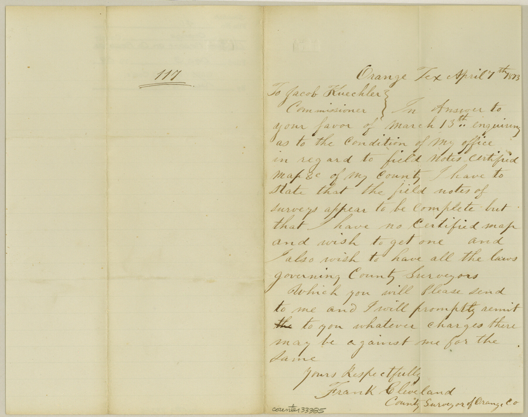
Orange County Sketch File 43
[County Surveyor report on county records]
-
Map/Doc
33385
-
Collection
General Map Collection
-
Object Dates
4/7/1873 (Creation Date)
12/3/1984 (File Date)
-
People and Organizations
Frank Cleveland (Surveyor/Engineer)
-
Counties
Orange
-
Subjects
Surveying Sketch File
-
Height x Width
8.2 x 10.3 inches
20.8 x 26.2 cm
-
Medium
paper, manuscript
Part of: General Map Collection
Map of Travis County

Print $20.00
- Digital $50.00
Map of Travis County
1875
Size 20.6 x 26.4 inches
Map/Doc 4093
Burnet County Sketch File 29

Print $4.00
- Digital $50.00
Burnet County Sketch File 29
1874
Size 10.1 x 8.1 inches
Map/Doc 16744
The City of Austin and Suburbs

Print $40.00
- Digital $50.00
The City of Austin and Suburbs
1919
Size 120.7 x 41.2 inches
Map/Doc 88863
Hays County Working Sketch 11

Print $20.00
- Digital $50.00
Hays County Working Sketch 11
1950
Size 22.7 x 33.1 inches
Map/Doc 66085
Taylor County Rolled Sketch 27B

Print $20.00
- Digital $50.00
Taylor County Rolled Sketch 27B
Size 19.2 x 17.7 inches
Map/Doc 7920
Wichita County Sketch File A

Print $4.00
- Digital $50.00
Wichita County Sketch File A
1861
Size 7.8 x 10.3 inches
Map/Doc 40036
Montague County Working Sketch 42

Print $20.00
- Digital $50.00
Montague County Working Sketch 42
2009
Size 19.9 x 25.4 inches
Map/Doc 89004
Hardeman County Sketch File 19

Print $6.00
- Digital $50.00
Hardeman County Sketch File 19
Size 14.3 x 8.8 inches
Map/Doc 25030
Briscoe County Working Sketch 10

Print $20.00
- Digital $50.00
Briscoe County Working Sketch 10
1958
Size 30.0 x 24.2 inches
Map/Doc 67813
Angelina County Sketch File 17a

Print $8.00
- Digital $50.00
Angelina County Sketch File 17a
1863
Size 13.1 x 8.2 inches
Map/Doc 13024
Hutchinson County Rolled Sketch 40

Print $20.00
- Digital $50.00
Hutchinson County Rolled Sketch 40
1981
Size 26.5 x 37.5 inches
Map/Doc 6306
Newton County Rolled Sketch 27A
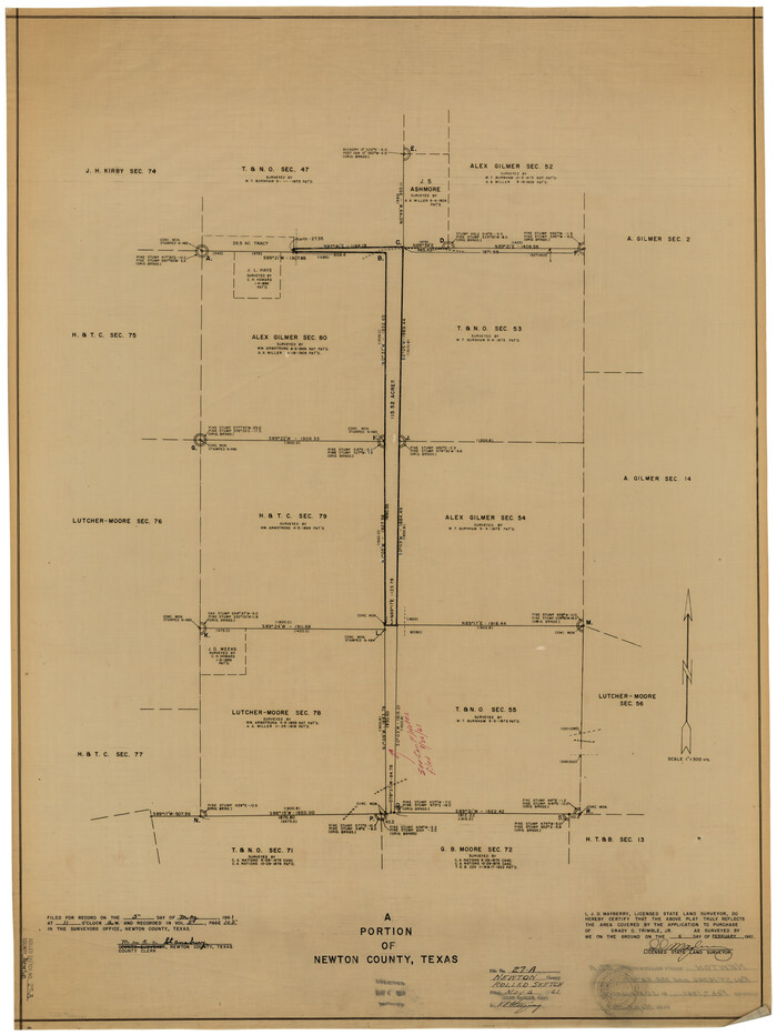
Print $20.00
- Digital $50.00
Newton County Rolled Sketch 27A
1961
Size 35.9 x 27.1 inches
Map/Doc 6857
You may also like
Baylor County Rolled Sketch 12

Print $20.00
- Digital $50.00
Baylor County Rolled Sketch 12
1986
Size 22.4 x 36.0 inches
Map/Doc 5129
Dallas County Working Sketch 7

Print $20.00
- Digital $50.00
Dallas County Working Sketch 7
1952
Size 17.3 x 23.5 inches
Map/Doc 68573
Atascosa County Sketch File 40

Print $40.00
- Digital $50.00
Atascosa County Sketch File 40
1881
Size 15.2 x 12.6 inches
Map/Doc 13835
Chambers County Sketch File 42

Print $149.00
- Digital $50.00
Chambers County Sketch File 42
1917
Size 14.3 x 8.8 inches
Map/Doc 17700
Flight Mission No. BRA-7M, Frame 43, Jefferson County

Print $20.00
- Digital $50.00
Flight Mission No. BRA-7M, Frame 43, Jefferson County
1953
Size 18.6 x 22.4 inches
Map/Doc 85494
Working Sketch in Stephens County

Print $2.00
- Digital $50.00
Working Sketch in Stephens County
1919
Size 9.1 x 11.2 inches
Map/Doc 91910
[Sketch showing T. &P. R. R. Co. Blks. 32, 33, 34 Township 4N, and J. Poitevent Block I]
![89629, [Sketch showing T. &P. R. R. Co. Blks. 32, 33, 34 Township 4N, and J. Poitevent Block I], Twichell Survey Records](https://historictexasmaps.com/wmedia_w700/maps/89629-1.tif.jpg)
Print $40.00
- Digital $50.00
[Sketch showing T. &P. R. R. Co. Blks. 32, 33, 34 Township 4N, and J. Poitevent Block I]
Size 19.2 x 49.8 inches
Map/Doc 89629
America's Fun-Tier: Texas 1967 Official State Highway Map

Digital $50.00
America's Fun-Tier: Texas 1967 Official State Highway Map
Size 28.3 x 36.6 inches
Map/Doc 94322
![94197, New Mexico [Verso], General Map Collection](https://historictexasmaps.com/wmedia_w700/maps/94197.tif.jpg)
J. F. Kelley Farm

Print $20.00
- Digital $50.00
J. F. Kelley Farm
Size 16.3 x 19.5 inches
Map/Doc 92408
Real County Rolled Sketch JCA

Print $20.00
- Digital $50.00
Real County Rolled Sketch JCA
Size 27.9 x 36.5 inches
Map/Doc 7470
Outer Continental Shelf Leasing Maps (Texas Offshore Operations)

Print $20.00
- Digital $50.00
Outer Continental Shelf Leasing Maps (Texas Offshore Operations)
1954
Size 20.3 x 15.5 inches
Map/Doc 75839