Waller County Sketch File 1a

Print $20.00
- Digital $50.00
Waller County Sketch File 1a
Size: 25.4 x 16.6 inches
12598
Grimes County Sketch File 3

Print $20.00
- Digital $50.00
Grimes County Sketch File 3
1871
Size: 10.6 x 12.1 inches
24626
Grimes County Sketch File 4

Print $4.00
- Digital $50.00
Grimes County Sketch File 4
1872
Size: 12.7 x 8.0 inches
24635
Grimes County Sketch File 4b

Print $10.00
- Digital $50.00
Grimes County Sketch File 4b
1873
Size: 10.2 x 8.4 inches
24637
Grimes County Sketch File 5

Print $4.00
- Digital $50.00
Grimes County Sketch File 5
1881
Size: 9.2 x 8.3 inches
24642
Grimes County Sketch File 4a

Print $6.00
- Digital $50.00
Grimes County Sketch File 4a
1873
Size: 13.0 x 8.4 inches
24656
Montgomery County Sketch File 37

Print $6.00
- Digital $50.00
Montgomery County Sketch File 37
Size: 12.6 x 8.2 inches
31916
Map of Grimes County
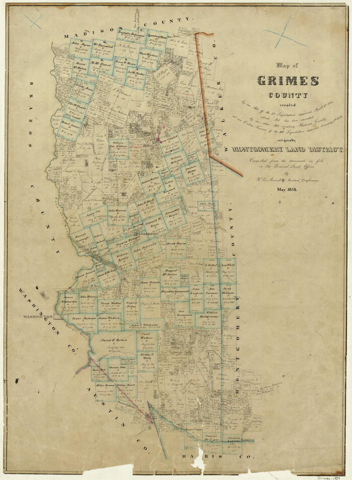
Print $20.00
- Digital $50.00
Map of Grimes County
1858
Size: 29.1 x 21.4 inches
3605
Map of Grimes County

Print $20.00
- Digital $50.00
Map of Grimes County
1881
Size: 29.9 x 16.3 inches
3606
Waller County Sketch File 9

Print $4.00
- Digital $50.00
Waller County Sketch File 9
Size: 9.1 x 7.8 inches
39610
Map of Grimes County, Texas

Print $20.00
- Digital $50.00
Map of Grimes County, Texas
1880
Size: 29.5 x 15.6 inches
432
Grimes County Rolled Sketch 2

Print $20.00
- Digital $50.00
Grimes County Rolled Sketch 2
Size: 29.2 x 24.3 inches
6043
Grimes County Working Sketch 1

Print $20.00
- Digital $50.00
Grimes County Working Sketch 1
1920
Size: 33.1 x 30.7 inches
63292
Grimes County Working Sketch 2

Print $20.00
- Digital $50.00
Grimes County Working Sketch 2
1941
Size: 13.2 x 20.9 inches
63293
Grimes County Working Sketch 3

Print $20.00
- Digital $50.00
Grimes County Working Sketch 3
1946
Size: 34.1 x 29.1 inches
63294
Grimes County Working Sketch 4

Print $20.00
- Digital $50.00
Grimes County Working Sketch 4
1948
Size: 20.0 x 24.5 inches
63295
Grimes County Working Sketch 5

Print $40.00
- Digital $50.00
Grimes County Working Sketch 5
1949
Size: 43.6 x 83.2 inches
63296
Grimes County Working Sketch 6

Print $20.00
- Digital $50.00
Grimes County Working Sketch 6
1951
Size: 33.2 x 33.4 inches
63297
Grimes County Working Sketch 7

Print $20.00
- Digital $50.00
Grimes County Working Sketch 7
1963
Size: 27.2 x 33.0 inches
63298
Grimes County Working Sketch 8

Print $20.00
- Digital $50.00
Grimes County Working Sketch 8
1976
Size: 35.0 x 32.7 inches
63299
Grimes County Working Sketch 9

Print $20.00
- Digital $50.00
Grimes County Working Sketch 9
1977
Size: 20.1 x 30.3 inches
63300
Grimes County Working Sketch 10

Print $20.00
- Digital $50.00
Grimes County Working Sketch 10
1980
Size: 21.5 x 29.6 inches
63301
Grimes County Working Sketch 11

Print $20.00
- Digital $50.00
Grimes County Working Sketch 11
1981
Size: 22.7 x 22.6 inches
63302
Grimes County Working Sketch 12

Print $20.00
- Digital $50.00
Grimes County Working Sketch 12
1982
Size: 18.3 x 21.6 inches
63303
Grimes County Working Sketch 13

Print $20.00
- Digital $50.00
Grimes County Working Sketch 13
1982
Size: 39.4 x 47.7 inches
63304
Grimes County Working Sketch 14

Print $20.00
- Digital $50.00
Grimes County Working Sketch 14
1983
Size: 33.0 x 34.1 inches
63305
Grimes County Working Sketch 15

Print $20.00
- Digital $50.00
Grimes County Working Sketch 15
1988
Size: 42.4 x 42.4 inches
63306
Waller County Sketch File 1a
Print $20.00
- Digital $50.00
Waller County Sketch File 1a
-
Size
25.4 x 16.6 inches
-
Map/Doc
12598
Grimes County

Print $40.00
- Digital $50.00
Grimes County
1922
-
Size
58.1 x 32.8 inches
-
Map/Doc
1845
-
Creation Date
1922
Grimes County Sketch File 3
Print $20.00
- Digital $50.00
Grimes County Sketch File 3
1871
-
Size
10.6 x 12.1 inches
-
Map/Doc
24626
-
Creation Date
1871
Grimes County Sketch File 4
Print $4.00
- Digital $50.00
Grimes County Sketch File 4
1872
-
Size
12.7 x 8.0 inches
-
Map/Doc
24635
-
Creation Date
1872
Grimes County Sketch File 4b
Print $10.00
- Digital $50.00
Grimes County Sketch File 4b
1873
-
Size
10.2 x 8.4 inches
-
Map/Doc
24637
-
Creation Date
1873
Grimes County Sketch File 5
Print $4.00
- Digital $50.00
Grimes County Sketch File 5
1881
-
Size
9.2 x 8.3 inches
-
Map/Doc
24642
-
Creation Date
1881
Grimes County Sketch File 4a
Print $6.00
- Digital $50.00
Grimes County Sketch File 4a
1873
-
Size
13.0 x 8.4 inches
-
Map/Doc
24656
-
Creation Date
1873
Montgomery County Sketch File 37
Print $6.00
- Digital $50.00
Montgomery County Sketch File 37
-
Size
12.6 x 8.2 inches
-
Map/Doc
31916
Map of Grimes County
Print $20.00
- Digital $50.00
Map of Grimes County
1858
-
Size
29.1 x 21.4 inches
-
Map/Doc
3605
-
Creation Date
1858
Map of Grimes County
Print $20.00
- Digital $50.00
Map of Grimes County
1881
-
Size
29.9 x 16.3 inches
-
Map/Doc
3606
-
Creation Date
1881
Waller County Sketch File 9
Print $4.00
- Digital $50.00
Waller County Sketch File 9
-
Size
9.1 x 7.8 inches
-
Map/Doc
39610
Map of Grimes County, Texas
Print $20.00
- Digital $50.00
Map of Grimes County, Texas
1880
-
Size
29.5 x 15.6 inches
-
Map/Doc
432
-
Creation Date
1880
Grimes County

Print $20.00
- Digital $50.00
Grimes County
1872
-
Size
29.2 x 16.1 inches
-
Map/Doc
4693
-
Creation Date
1872
Grimes County

Print $40.00
- Digital $50.00
Grimes County
1922
-
Size
58.5 x 33.3 inches
-
Map/Doc
4964
-
Creation Date
1922
Grimes County Rolled Sketch 2
Print $20.00
- Digital $50.00
Grimes County Rolled Sketch 2
-
Size
29.2 x 24.3 inches
-
Map/Doc
6043
Grimes County Working Sketch 1
Print $20.00
- Digital $50.00
Grimes County Working Sketch 1
1920
-
Size
33.1 x 30.7 inches
-
Map/Doc
63292
-
Creation Date
1920
Grimes County Working Sketch 2
Print $20.00
- Digital $50.00
Grimes County Working Sketch 2
1941
-
Size
13.2 x 20.9 inches
-
Map/Doc
63293
-
Creation Date
1941
Grimes County Working Sketch 3
Print $20.00
- Digital $50.00
Grimes County Working Sketch 3
1946
-
Size
34.1 x 29.1 inches
-
Map/Doc
63294
-
Creation Date
1946
Grimes County Working Sketch 4
Print $20.00
- Digital $50.00
Grimes County Working Sketch 4
1948
-
Size
20.0 x 24.5 inches
-
Map/Doc
63295
-
Creation Date
1948
Grimes County Working Sketch 5
Print $40.00
- Digital $50.00
Grimes County Working Sketch 5
1949
-
Size
43.6 x 83.2 inches
-
Map/Doc
63296
-
Creation Date
1949
Grimes County Working Sketch 6
Print $20.00
- Digital $50.00
Grimes County Working Sketch 6
1951
-
Size
33.2 x 33.4 inches
-
Map/Doc
63297
-
Creation Date
1951
Grimes County Working Sketch 7
Print $20.00
- Digital $50.00
Grimes County Working Sketch 7
1963
-
Size
27.2 x 33.0 inches
-
Map/Doc
63298
-
Creation Date
1963
Grimes County Working Sketch 8
Print $20.00
- Digital $50.00
Grimes County Working Sketch 8
1976
-
Size
35.0 x 32.7 inches
-
Map/Doc
63299
-
Creation Date
1976
Grimes County Working Sketch 9
Print $20.00
- Digital $50.00
Grimes County Working Sketch 9
1977
-
Size
20.1 x 30.3 inches
-
Map/Doc
63300
-
Creation Date
1977
Grimes County Working Sketch 10
Print $20.00
- Digital $50.00
Grimes County Working Sketch 10
1980
-
Size
21.5 x 29.6 inches
-
Map/Doc
63301
-
Creation Date
1980
Grimes County Working Sketch 11
Print $20.00
- Digital $50.00
Grimes County Working Sketch 11
1981
-
Size
22.7 x 22.6 inches
-
Map/Doc
63302
-
Creation Date
1981
Grimes County Working Sketch 12
Print $20.00
- Digital $50.00
Grimes County Working Sketch 12
1982
-
Size
18.3 x 21.6 inches
-
Map/Doc
63303
-
Creation Date
1982
Grimes County Working Sketch 13
Print $20.00
- Digital $50.00
Grimes County Working Sketch 13
1982
-
Size
39.4 x 47.7 inches
-
Map/Doc
63304
-
Creation Date
1982
Grimes County Working Sketch 14
Print $20.00
- Digital $50.00
Grimes County Working Sketch 14
1983
-
Size
33.0 x 34.1 inches
-
Map/Doc
63305
-
Creation Date
1983
Grimes County Working Sketch 15
Print $20.00
- Digital $50.00
Grimes County Working Sketch 15
1988
-
Size
42.4 x 42.4 inches
-
Map/Doc
63306
-
Creation Date
1988