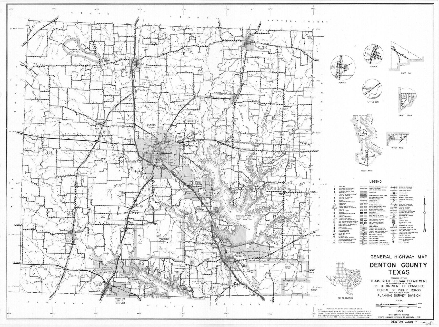
General Highway Map, Denton County, Texas
-
Map/Doc
79441
-
Collection
Texas State Library and Archives
-
Object Dates
1961 (Creation Date)
-
People and Organizations
Texas State Highway Department (Publisher)
-
Counties
Denton
-
Subjects
County
-
Height x Width
18.2 x 24.5 inches
46.2 x 62.2 cm
-
Comments
Prints available courtesy of the Texas State Library and Archives.
More info can be found here: TSLAC Map 05111
Part of: Texas State Library and Archives
General Highway Map, Hood County, Somervell County, Texas

Print $20.00
General Highway Map, Hood County, Somervell County, Texas
1940
Size 18.3 x 24.8 inches
Map/Doc 79131
Oil and Gas Fields in the State of Texas

Print $40.00
Oil and Gas Fields in the State of Texas
1927
Size 58.0 x 38.0 inches
Map/Doc 76304
Map of Texas Containing the Latest Grants and Discoveries

Print $20.00
Map of Texas Containing the Latest Grants and Discoveries
1836
Size 16.2 x 10.6 inches
Map/Doc 76245
General Highway Map, Cherokee County, Texas

Print $20.00
General Highway Map, Cherokee County, Texas
1961
Size 18.2 x 24.7 inches
Map/Doc 79406
General Highway Map, Hansford County, Texas

Print $20.00
General Highway Map, Hansford County, Texas
1940
Size 18.4 x 25.0 inches
Map/Doc 79112
General Highway Map, Gillespie County, Texas

Print $20.00
General Highway Map, Gillespie County, Texas
1961
Size 18.1 x 24.5 inches
Map/Doc 79479
General Highway Map, Brazoria County, Texas

Print $20.00
General Highway Map, Brazoria County, Texas
1939
Size 18.4 x 24.9 inches
Map/Doc 79025
General Highway Map, Brazos County, Texas

Print $20.00
General Highway Map, Brazos County, Texas
1961
Size 24.9 x 18.3 inches
Map/Doc 79384
General Highway Map, Hidalgo County, Texas

Print $20.00
General Highway Map, Hidalgo County, Texas
1940
Size 18.4 x 24.7 inches
Map/Doc 79127
General Highway Map, Zapata County, Texas

Print $20.00
General Highway Map, Zapata County, Texas
1961
Size 18.2 x 24.8 inches
Map/Doc 79721
Stremme General Land Office Drawings, front view

Print $20.00
Stremme General Land Office Drawings, front view
Size 14.0 x 20.8 inches
Map/Doc 79738
General Highway Map, Oldham County, Deaf Smith County, Texas

Print $20.00
General Highway Map, Oldham County, Deaf Smith County, Texas
1940
Size 18.3 x 25.2 inches
Map/Doc 79072
You may also like
Hardeman County Sketch File A3

Print $4.00
- Digital $50.00
Hardeman County Sketch File A3
1890
Size 14.2 x 8.8 inches
Map/Doc 25052
Upton County Sketch File S

Print $8.00
- Digital $50.00
Upton County Sketch File S
Size 13.4 x 9.1 inches
Map/Doc 38850
The Chief Justice County of Sabine. Lands in Conflict with Jasper and San Augustine Counties

Print $20.00
The Chief Justice County of Sabine. Lands in Conflict with Jasper and San Augustine Counties
2020
Size 20.0 x 21.7 inches
Map/Doc 96069
Reconnoissance of Sabine River and Valley

Print $20.00
Reconnoissance of Sabine River and Valley
1863
Size 42.5 x 30.3 inches
Map/Doc 97500
Schleicher County Sketch File 35

Print $20.00
- Digital $50.00
Schleicher County Sketch File 35
1951
Size 13.8 x 19.4 inches
Map/Doc 12308
Roswell District, New Mexico

Print $40.00
- Digital $50.00
Roswell District, New Mexico
Size 40.7 x 57.6 inches
Map/Doc 89817
Flight Mission No. BRA-7M, Frame 33, Jefferson County

Print $20.00
- Digital $50.00
Flight Mission No. BRA-7M, Frame 33, Jefferson County
1953
Size 18.6 x 22.4 inches
Map/Doc 85484
Travis County Rolled Sketch 59

Print $20.00
- Digital $50.00
Travis County Rolled Sketch 59
1987
Size 17.0 x 22.6 inches
Map/Doc 8050
Aransas County Sketch File 26

Print $28.00
- Digital $50.00
Aransas County Sketch File 26
1896
Size 5.2 x 4.7 inches
Map/Doc 13219
Map of the country in the vicinity of San Antonio de Bexar reduced in part from the county map of Bexar with additions by J. Edmd. Blake, 1st Lieut Topl. Engs.

Print $20.00
- Digital $50.00
Map of the country in the vicinity of San Antonio de Bexar reduced in part from the county map of Bexar with additions by J. Edmd. Blake, 1st Lieut Topl. Engs.
1845
Size 18.1 x 25.9 inches
Map/Doc 72723
[Surveys in Austin's Colony at Carancahua Bay]
![172, [Surveys in Austin's Colony at Carancahua Bay], General Map Collection](https://historictexasmaps.com/wmedia_w700/maps/172.tif.jpg)
Print $20.00
- Digital $50.00
[Surveys in Austin's Colony at Carancahua Bay]
Size 22.5 x 17.4 inches
Map/Doc 172
[Corpus Christi Bay, Padre Island, Mustang Island, Laguna de la Madre, King and Kenedy's Pasture]
![73042, [Corpus Christi Bay, Padre Island, Mustang Island, Laguna de la Madre, King and Kenedy's Pasture], General Map Collection](https://historictexasmaps.com/wmedia_w700/maps/73042.tif.jpg)
Print $20.00
- Digital $50.00
[Corpus Christi Bay, Padre Island, Mustang Island, Laguna de la Madre, King and Kenedy's Pasture]
Size 26.2 x 18.2 inches
Map/Doc 73042