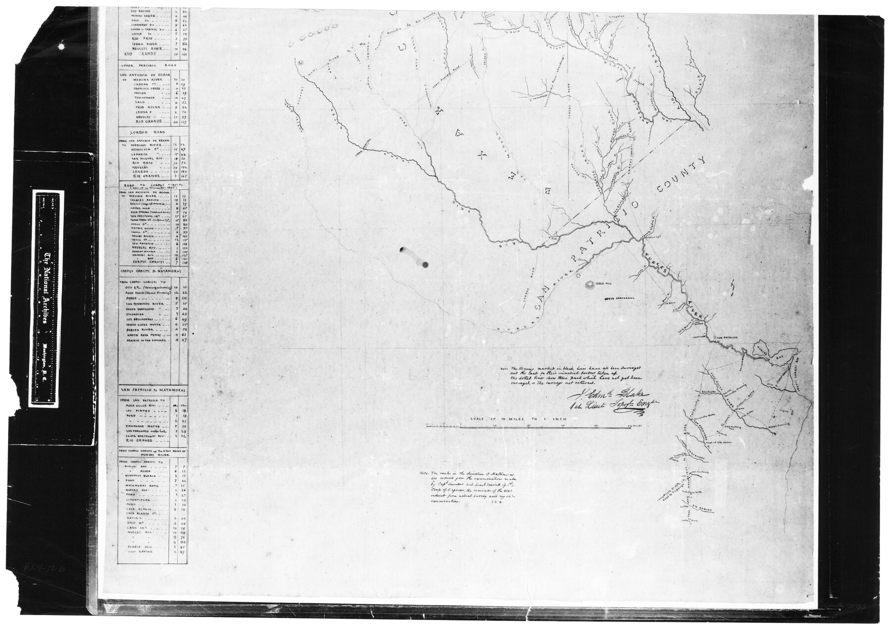
Map of the country in the vicinity of San Antonio de Bexar reduced in part from the county map of Bexar with additions by J. Edmd. Blake, 1st Lieut Topl. Engs.
RL-1-12b
-
Map/Doc
72723
-
Collection
General Map Collection
-
Object Dates
1845 (Creation Date)
-
People and Organizations
J. Edmond Blake (Author)
-
Counties
Bexar
-
Subjects
Military
-
Height x Width
18.1 x 25.9 inches
46.0 x 65.8 cm
-
Comments
B/W photostat copy from National Archives in multiple pieces.
Part of: General Map Collection
Map of Runnels County

Print $20.00
- Digital $50.00
Map of Runnels County
1879
Size 25.9 x 18.5 inches
Map/Doc 4620
Fayette County Sketch File 4

Print $4.00
- Digital $50.00
Fayette County Sketch File 4
Size 11.7 x 7.9 inches
Map/Doc 22504
United States - Gulf Coast - From Latitude 26° 33' to the Rio Grande Texas

Print $20.00
- Digital $50.00
United States - Gulf Coast - From Latitude 26° 33' to the Rio Grande Texas
1913
Size 28.0 x 18.2 inches
Map/Doc 72833
Yoakum County Sketch File 10

Print $20.00
- Digital $50.00
Yoakum County Sketch File 10
1902
Size 33.7 x 18.8 inches
Map/Doc 12706
Goliad County Sketch File 26a

Print $10.00
- Digital $50.00
Goliad County Sketch File 26a
Size 12.8 x 8.3 inches
Map/Doc 24321
Hamilton County Sketch File 16

Print $20.00
- Digital $50.00
Hamilton County Sketch File 16
1898
Size 22.6 x 19.6 inches
Map/Doc 11616
Cherokee County Working Sketch 10

Print $40.00
- Digital $50.00
Cherokee County Working Sketch 10
1957
Size 58.1 x 43.2 inches
Map/Doc 67965
Briscoe County Rolled Sketch 14A

Print $40.00
- Digital $50.00
Briscoe County Rolled Sketch 14A
1913
Size 34.6 x 48.1 inches
Map/Doc 8530
Falls County Sketch File 12

Print $8.00
- Digital $50.00
Falls County Sketch File 12
1870
Size 8.2 x 10.1 inches
Map/Doc 22364
Flight Mission No. CUG-2P, Frame 9, Kleberg County

Print $20.00
- Digital $50.00
Flight Mission No. CUG-2P, Frame 9, Kleberg County
1956
Size 18.6 x 22.2 inches
Map/Doc 86181
Ochiltree County Working Sketch 8

Print $20.00
- Digital $50.00
Ochiltree County Working Sketch 8
1982
Size 23.4 x 20.8 inches
Map/Doc 71321
Duval County Working Sketch 34

Print $20.00
- Digital $50.00
Duval County Working Sketch 34
1953
Size 35.8 x 25.5 inches
Map/Doc 68758
You may also like
Flight Mission No. BQR-7K, Frame 33, Brazoria County

Print $20.00
- Digital $50.00
Flight Mission No. BQR-7K, Frame 33, Brazoria County
1952
Size 18.7 x 22.3 inches
Map/Doc 84031
Baylor County Rolled Sketch 10

Print $20.00
- Digital $50.00
Baylor County Rolled Sketch 10
Size 28.0 x 14.0 inches
Map/Doc 5127
Jasper County Rolled Sketch 4

Print $20.00
- Digital $50.00
Jasper County Rolled Sketch 4
1947
Size 40.0 x 31.1 inches
Map/Doc 6351
Mills County Working Sketch 17

Print $20.00
- Digital $50.00
Mills County Working Sketch 17
1963
Size 20.4 x 17.9 inches
Map/Doc 71047
Gaines County Working Sketch 13

Print $20.00
- Digital $50.00
Gaines County Working Sketch 13
1954
Size 36.8 x 39.4 inches
Map/Doc 69313
General Highway Map, Mason County, Texas

Print $20.00
General Highway Map, Mason County, Texas
1961
Size 18.3 x 24.8 inches
Map/Doc 79584
Portion of States Submerged Area in Matagorda Bay

Print $20.00
- Digital $50.00
Portion of States Submerged Area in Matagorda Bay
1921
Size 15.7 x 15.1 inches
Map/Doc 2950
Montgomery County Rolled Sketch 40

Print $393.00
- Digital $50.00
Montgomery County Rolled Sketch 40
1970
Size 10.3 x 16.0 inches
Map/Doc 46793
Honey Grove, Tex., Fannin County, 1886

Print $20.00
Honey Grove, Tex., Fannin County, 1886
1886
Size 18.4 x 23.9 inches
Map/Doc 93479
Houston County Working Sketch Graphic Index

Print $40.00
- Digital $50.00
Houston County Working Sketch Graphic Index
1944
Size 48.1 x 42.7 inches
Map/Doc 76582
Upshur County Boundary File 1

Print $30.00
- Digital $50.00
Upshur County Boundary File 1
Size 9.4 x 8.6 inches
Map/Doc 59500
[Texas Boundary Line]
![92069, [Texas Boundary Line], Twichell Survey Records](https://historictexasmaps.com/wmedia_w700/maps/92069-1.tif.jpg)
Print $20.00
- Digital $50.00
[Texas Boundary Line]
Size 31.8 x 18.1 inches
Map/Doc 92069