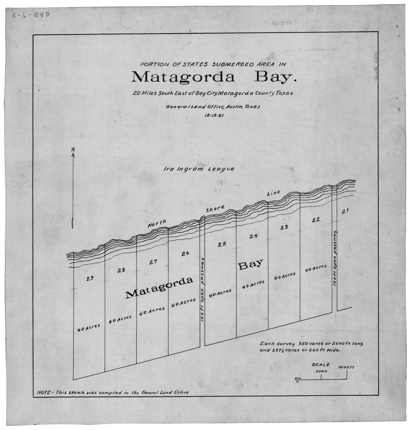
Portion of States Submerged Area in Matagorda Bay
K-7-64 (a-h)
-
Map/Doc
2950
-
Collection
General Map Collection
-
Object Dates
12/19/1921 (Creation Date)
-
Counties
Matagorda
-
Subjects
Energy Offshore Submerged Area
-
Height x Width
15.7 x 15.1 inches
39.9 x 38.4 cm
Part of: General Map Collection
Pecos County Sketch File 29a

Print $4.00
- Digital $50.00
Pecos County Sketch File 29a
1911
Size 14.2 x 8.6 inches
Map/Doc 33690
King County Rolled Sketch 8

Print $20.00
- Digital $50.00
King County Rolled Sketch 8
1902
Size 34.8 x 29.8 inches
Map/Doc 6531

Stonewall County

Print $20.00
- Digital $50.00
Stonewall County
1882
Size 27.8 x 20.8 inches
Map/Doc 4059
Austin County Boundary File 5a

Print $6.00
- Digital $50.00
Austin County Boundary File 5a
Size 14.1 x 8.7 inches
Map/Doc 50252
Jones County Sketch File 21

Print $56.00
- Digital $50.00
Jones County Sketch File 21
2010
Map/Doc 93292
Trinity River, Levee Improvement Districts, Widths of Floodways/Pilot Grove Creek and East Fork Trinity River

Print $6.00
- Digital $50.00
Trinity River, Levee Improvement Districts, Widths of Floodways/Pilot Grove Creek and East Fork Trinity River
1920
Size 33.0 x 17.1 inches
Map/Doc 65259
Crane County Sketch File 5

Print $6.00
- Digital $50.00
Crane County Sketch File 5
1886
Size 14.3 x 8.6 inches
Map/Doc 19564
Shelby County Rolled Sketch 19

Print $20.00
- Digital $50.00
Shelby County Rolled Sketch 19
1975
Size 24.6 x 40.4 inches
Map/Doc 7784
Aransas County Sketch File 21

Print $2.00
- Digital $50.00
Aransas County Sketch File 21
Size 8.0 x 8.9 inches
Map/Doc 13157
Newton County Working Sketch 34

Print $20.00
- Digital $50.00
Newton County Working Sketch 34
1959
Size 27.0 x 32.6 inches
Map/Doc 71280
Motley County Sketch File 6a (S)

Print $40.00
- Digital $50.00
Motley County Sketch File 6a (S)
1894
Size 14.3 x 14.4 inches
Map/Doc 32147
You may also like
Stonewall County Working Sketch 23

Print $20.00
- Digital $50.00
Stonewall County Working Sketch 23
1967
Size 23.4 x 26.1 inches
Map/Doc 62330
Hemphill County Working Sketch 5

Print $20.00
- Digital $50.00
Hemphill County Working Sketch 5
1940
Size 31.6 x 42.4 inches
Map/Doc 66100
Knox County Sketch File 10a

Print $40.00
- Digital $50.00
Knox County Sketch File 10a
1902
Size 9.5 x 19.0 inches
Map/Doc 29223
Starr County Sketch File 46 1/2

Print $20.00
- Digital $50.00
Starr County Sketch File 46 1/2
1978
Size 17.9 x 17.2 inches
Map/Doc 12344
El Paso County Boundary File 7a

Print $20.00
- Digital $50.00
El Paso County Boundary File 7a
Size 14.2 x 8.3 inches
Map/Doc 53094
Map of the Southern Pacific Company and connections

Print $20.00
- Digital $50.00
Map of the Southern Pacific Company and connections
1890
Size 9.6 x 23.8 inches
Map/Doc 95759
Atascosa County Working Sketch 23

Print $40.00
- Digital $50.00
Atascosa County Working Sketch 23
1958
Size 38.8 x 57.1 inches
Map/Doc 68434
The Beautiful Valley of the Lower Rio Grande

The Beautiful Valley of the Lower Rio Grande
1925
Map/Doc 96735
Hardin County Rolled Sketch 13

Print $20.00
- Digital $50.00
Hardin County Rolled Sketch 13
1950
Size 29.8 x 27.4 inches
Map/Doc 9188
Real County Working Sketch 18

Print $20.00
- Digital $50.00
Real County Working Sketch 18
1943
Size 26.5 x 33.3 inches
Map/Doc 71910
Atascosa County Sketch File 5

Print $8.00
- Digital $50.00
Atascosa County Sketch File 5
1856
Size 8.2 x 12.4 inches
Map/Doc 13748
[Blocks GM, D2, D3, GP, and T]
![91503, [Blocks GM, D2, D3, GP, and T], Twichell Survey Records](https://historictexasmaps.com/wmedia_w700/maps/91503-1.tif.jpg)
Print $20.00
- Digital $50.00
[Blocks GM, D2, D3, GP, and T]
Size 32.8 x 15.9 inches
Map/Doc 91503