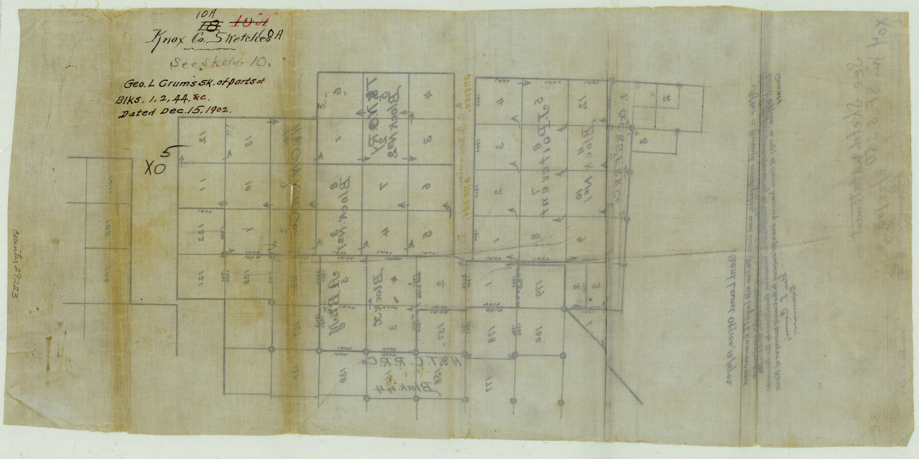
Knox County Sketch File 10a
[Sketch of parts of Blocks 1, 2, X, and 44]
-
Map/Doc
29223
-
Collection
General Map Collection
-
Object Dates
12/15/1902 (Creation Date)
-
People and Organizations
George L. Crum (Surveyor/Engineer)
-
Counties
Knox King
-
Subjects
Surveying Sketch File
-
Height x Width
9.5 x 19.0 inches
24.1 x 48.3 cm
-
Medium
paper, manuscript
Part of: General Map Collection
Presidio County Rolled Sketch 83A

Print $20.00
- Digital $50.00
Presidio County Rolled Sketch 83A
1930
Size 28.2 x 27.6 inches
Map/Doc 7370
Hutchinson County

Print $20.00
- Digital $50.00
Hutchinson County
1898
Size 41.8 x 37.6 inches
Map/Doc 66875
Map of Hidalgo County

Print $20.00
- Digital $50.00
Map of Hidalgo County
1880
Size 45.3 x 25.1 inches
Map/Doc 3667
No. 2 Chart of Corpus Christi Pass, Texas

Print $20.00
- Digital $50.00
No. 2 Chart of Corpus Christi Pass, Texas
1878
Size 18.3 x 27.4 inches
Map/Doc 73015
Collingsworth County Sketch File 9

Print $20.00
- Digital $50.00
Collingsworth County Sketch File 9
Size 16.5 x 12.0 inches
Map/Doc 11133
Flight Mission No. BRA-7M, Frame 75, Jefferson County

Print $20.00
- Digital $50.00
Flight Mission No. BRA-7M, Frame 75, Jefferson County
1953
Size 18.6 x 22.2 inches
Map/Doc 85497
Map Location of the Pecos & Northern Texas Railway from [illegible] through Deaf Smith County
![64180, Map Location of the Pecos & Northern Texas Railway from [illegible] through Deaf Smith County, General Map Collection](https://historictexasmaps.com/wmedia_w700/maps/64180-1.tif.jpg)
Print $40.00
- Digital $50.00
Map Location of the Pecos & Northern Texas Railway from [illegible] through Deaf Smith County
Size 16.3 x 71.8 inches
Map/Doc 64180
Railroad Track Map, T&PRRCo., Culberson County, Texas

Print $4.00
- Digital $50.00
Railroad Track Map, T&PRRCo., Culberson County, Texas
1910
Size 11.7 x 18.6 inches
Map/Doc 62830
Flight Mission No. CGI-1N, Frame 186, Cameron County

Print $20.00
- Digital $50.00
Flight Mission No. CGI-1N, Frame 186, Cameron County
1955
Size 18.5 x 22.1 inches
Map/Doc 84521
Index Map No. 1 - Rio Bravo del Norte section of boundary between the United States & Mexico; agreed upon by the Joint Commission under the Treaty of Guadalupe Hidalgo

Print $20.00
- Digital $50.00
Index Map No. 1 - Rio Bravo del Norte section of boundary between the United States & Mexico; agreed upon by the Joint Commission under the Treaty of Guadalupe Hidalgo
1852
Size 18.3 x 27.5 inches
Map/Doc 72860
Henderson County Working Sketch 16

Print $40.00
- Digital $50.00
Henderson County Working Sketch 16
1937
Size 49.9 x 30.9 inches
Map/Doc 66149
Midland County Working Sketch 34

Print $20.00
- Digital $50.00
Midland County Working Sketch 34
1983
Size 42.2 x 38.3 inches
Map/Doc 71015
You may also like
[Right of Way Map, Belton Branch of the M.K.&T. RR.]
![64228, [Right of Way Map, Belton Branch of the M.K.&T. RR.], General Map Collection](https://historictexasmaps.com/wmedia_w700/maps/64228.tif.jpg)
Print $20.00
- Digital $50.00
[Right of Way Map, Belton Branch of the M.K.&T. RR.]
1896
Size 22.1 x 7.3 inches
Map/Doc 64228
Rusk County Working Sketch 35

Print $20.00
- Digital $50.00
Rusk County Working Sketch 35
2005
Size 28.7 x 42.0 inches
Map/Doc 83584
Nueces County Rolled Sketch 103

Print $105.00
Nueces County Rolled Sketch 103
1985
Size 36.5 x 24.1 inches
Map/Doc 7078
Hardin County Working Sketch 18

Print $20.00
- Digital $50.00
Hardin County Working Sketch 18
1944
Size 18.7 x 22.0 inches
Map/Doc 63416
Donley County Boundary File 2

Print $10.00
- Digital $50.00
Donley County Boundary File 2
Size 8.7 x 11.3 inches
Map/Doc 52619
Brazos Santiago, Texas

Print $20.00
- Digital $50.00
Brazos Santiago, Texas
1900
Size 18.3 x 26.9 inches
Map/Doc 73031
Flight Mission No. DCL-5C, Frame 67, Kenedy County

Print $20.00
- Digital $50.00
Flight Mission No. DCL-5C, Frame 67, Kenedy County
1943
Size 18.5 x 22.2 inches
Map/Doc 85850
King County Working Sketch 14

Print $20.00
- Digital $50.00
King County Working Sketch 14
1979
Size 27.7 x 32.5 inches
Map/Doc 70178
![91799, [Block 2], Twichell Survey Records](https://historictexasmaps.com/wmedia_w700/maps/91799-1.tif.jpg)
Parker County Sketch File 6

Print $6.00
- Digital $50.00
Parker County Sketch File 6
1858
Size 6.9 x 6.0 inches
Map/Doc 33530
Fayette County Sketch File 3

Print $6.00
- Digital $50.00
Fayette County Sketch File 3
1863
Size 8.3 x 10.7 inches
Map/Doc 22501
Nueces County Rolled Sketch 26

Print $40.00
- Digital $50.00
Nueces County Rolled Sketch 26
1945
Size 24.3 x 122.6 inches
Map/Doc 9595