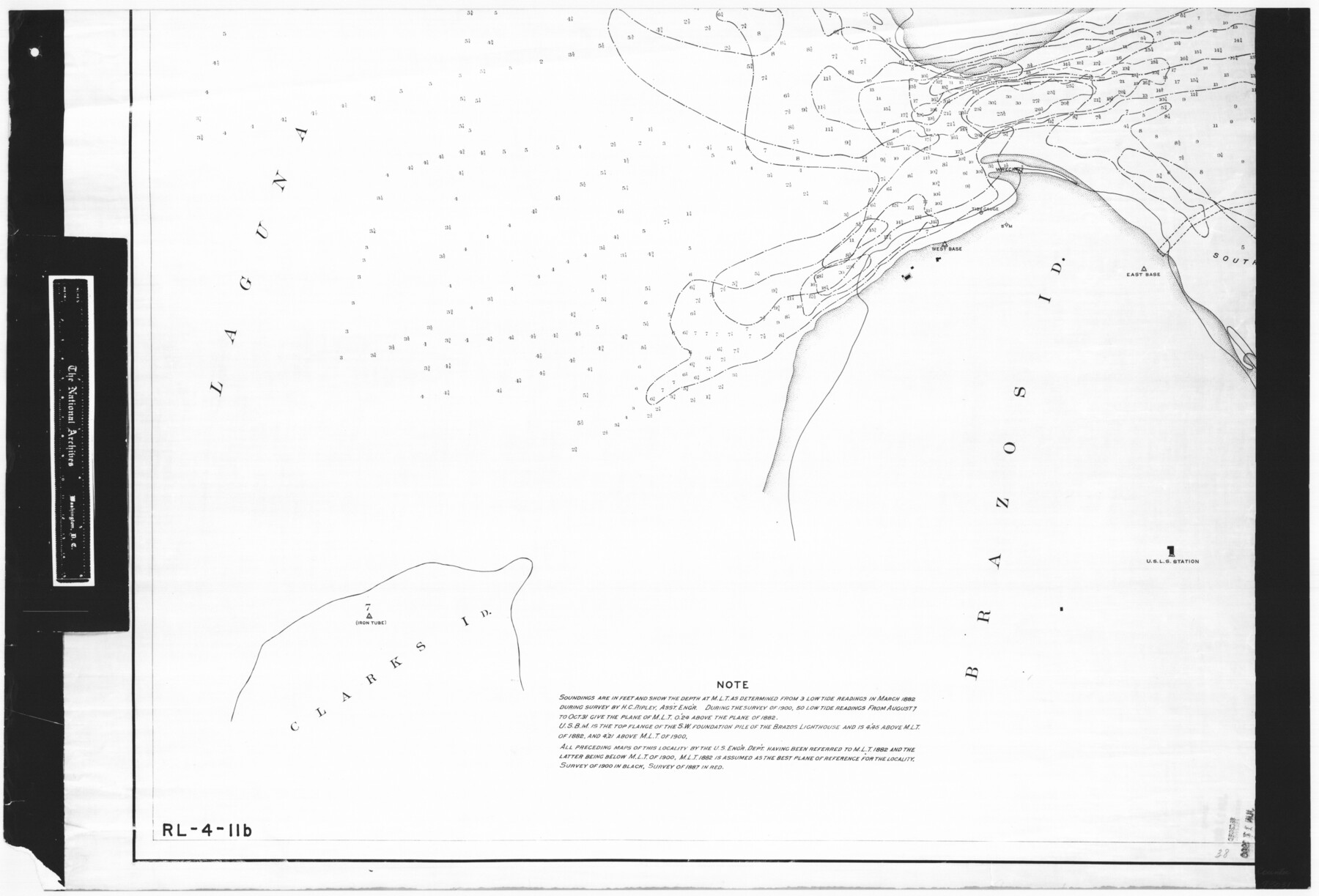
Brazos Santiago, Texas
RL-4-11b
-
Map/Doc
73031
-
Collection
General Map Collection
-
Object Dates
1900 (Creation Date)
-
People and Organizations
U. S. Army Corps of Engineers (Publisher)
J. Boyle (Surveyor/Engineer)
R.B. Talfor (Surveyor/Engineer)
J.Y. Johnson (Surveyor/Engineer)
-
Subjects
Nautical Charts
-
Height x Width
18.3 x 26.9 inches
46.5 x 68.3 cm
-
Comments
B/W photostat copy from National Archives in multiple pieces.
Part of: General Map Collection
Old Miscellaneous File 6

Print $4.00
- Digital $50.00
Old Miscellaneous File 6
1847
Size 4.2 x 7.6 inches
Map/Doc 75420
Sutton County Working Sketch 41

Print $20.00
- Digital $50.00
Sutton County Working Sketch 41
1950
Size 22.4 x 33.8 inches
Map/Doc 62384
Brazoria County Rolled Sketch 28

Print $40.00
- Digital $50.00
Brazoria County Rolled Sketch 28
Size 35.7 x 56.8 inches
Map/Doc 8458
Right of Way and Track Map, The Missouri, Kansas and Texas Ry. of Texas operated by the Missouri, Kansas and Texas Ry. of Texas, Henrietta Division

Print $40.00
- Digital $50.00
Right of Way and Track Map, The Missouri, Kansas and Texas Ry. of Texas operated by the Missouri, Kansas and Texas Ry. of Texas, Henrietta Division
1918
Size 25.1 x 56.7 inches
Map/Doc 64072
Flight Mission No. BRE-2P, Frame 83, Nueces County

Print $20.00
- Digital $50.00
Flight Mission No. BRE-2P, Frame 83, Nueces County
1956
Size 18.5 x 22.4 inches
Map/Doc 86778
Harrison County Working Sketch 6

Print $20.00
- Digital $50.00
Harrison County Working Sketch 6
1954
Size 27.6 x 38.7 inches
Map/Doc 66026
Henderson County Working Sketch 32

Print $40.00
- Digital $50.00
Henderson County Working Sketch 32
1963
Size 56.5 x 50.0 inches
Map/Doc 66165
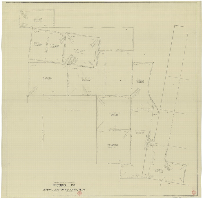
Presidio County Rolled Sketch 93A

Print $20.00
- Digital $50.00
Presidio County Rolled Sketch 93A
Size 29.6 x 28.2 inches
Map/Doc 7379
Roberts County Working Sketch 13

Print $20.00
- Digital $50.00
Roberts County Working Sketch 13
1971
Size 20.2 x 16.0 inches
Map/Doc 63539
Flight Mission No. BRA-8M, Frame 125, Jefferson County

Print $20.00
- Digital $50.00
Flight Mission No. BRA-8M, Frame 125, Jefferson County
1953
Size 15.9 x 15.7 inches
Map/Doc 85621
Navigation Maps of Gulf Intracoastal Waterway, Port Arthur to Brownsville, Texas

Print $4.00
- Digital $50.00
Navigation Maps of Gulf Intracoastal Waterway, Port Arthur to Brownsville, Texas
1951
Size 16.6 x 21.5 inches
Map/Doc 65440
Crockett County Rolled Sketch JAS

Print $40.00
- Digital $50.00
Crockett County Rolled Sketch JAS
1938
Size 52.9 x 42.7 inches
Map/Doc 8699
You may also like
McMullen County Sketch File 5

Print $4.00
- Digital $50.00
McMullen County Sketch File 5
1854
Size 8.7 x 8.3 inches
Map/Doc 31343
Shelby County Rolled Sketch 20

Print $20.00
- Digital $50.00
Shelby County Rolled Sketch 20
1983
Size 24.7 x 37.2 inches
Map/Doc 7785
[Map showing T&P Lands in El Paso County]
![88937, [Map showing T&P Lands in El Paso County], Library of Congress](https://historictexasmaps.com/wmedia_w700/maps/88937.tif.jpg)
Print $20.00
[Map showing T&P Lands in El Paso County]
Size 22.3 x 17.3 inches
Map/Doc 88937
Duval County Sketch File 20a

Print $5.00
- Digital $50.00
Duval County Sketch File 20a
Size 9.2 x 11.4 inches
Map/Doc 21322
![90594, [Block K7], Twichell Survey Records](https://historictexasmaps.com/wmedia_w700/maps/90594-1.tif.jpg)
Houston County

Print $20.00
- Digital $50.00
Houston County
1888
Size 24.5 x 26.1 inches
Map/Doc 3683
Fayette County Rolled Sketch 1

Print $20.00
- Digital $50.00
Fayette County Rolled Sketch 1
1981
Size 20.9 x 25.8 inches
Map/Doc 5876
Baylor County Working Sketch 7

Print $20.00
- Digital $50.00
Baylor County Working Sketch 7
1950
Size 31.4 x 24.0 inches
Map/Doc 67292
Terrell County Working Sketch 84c

Print $20.00
- Digital $50.00
Terrell County Working Sketch 84c
1992
Size 18.2 x 31.3 inches
Map/Doc 69607
Cameron County Aerial Photograph Index Sheet 7

Print $20.00
- Digital $50.00
Cameron County Aerial Photograph Index Sheet 7
1955
Size 21.8 x 16.2 inches
Map/Doc 83679
Presidio County Working Sketch 87
Print $20.00
- Digital $50.00
Presidio County Working Sketch 87
1971
Size 37.6 x 37.9 inches
Map/Doc 71764
Map of Eastland County

Print $20.00
- Digital $50.00
Map of Eastland County
1889
Size 22.9 x 21.2 inches
Map/Doc 3502