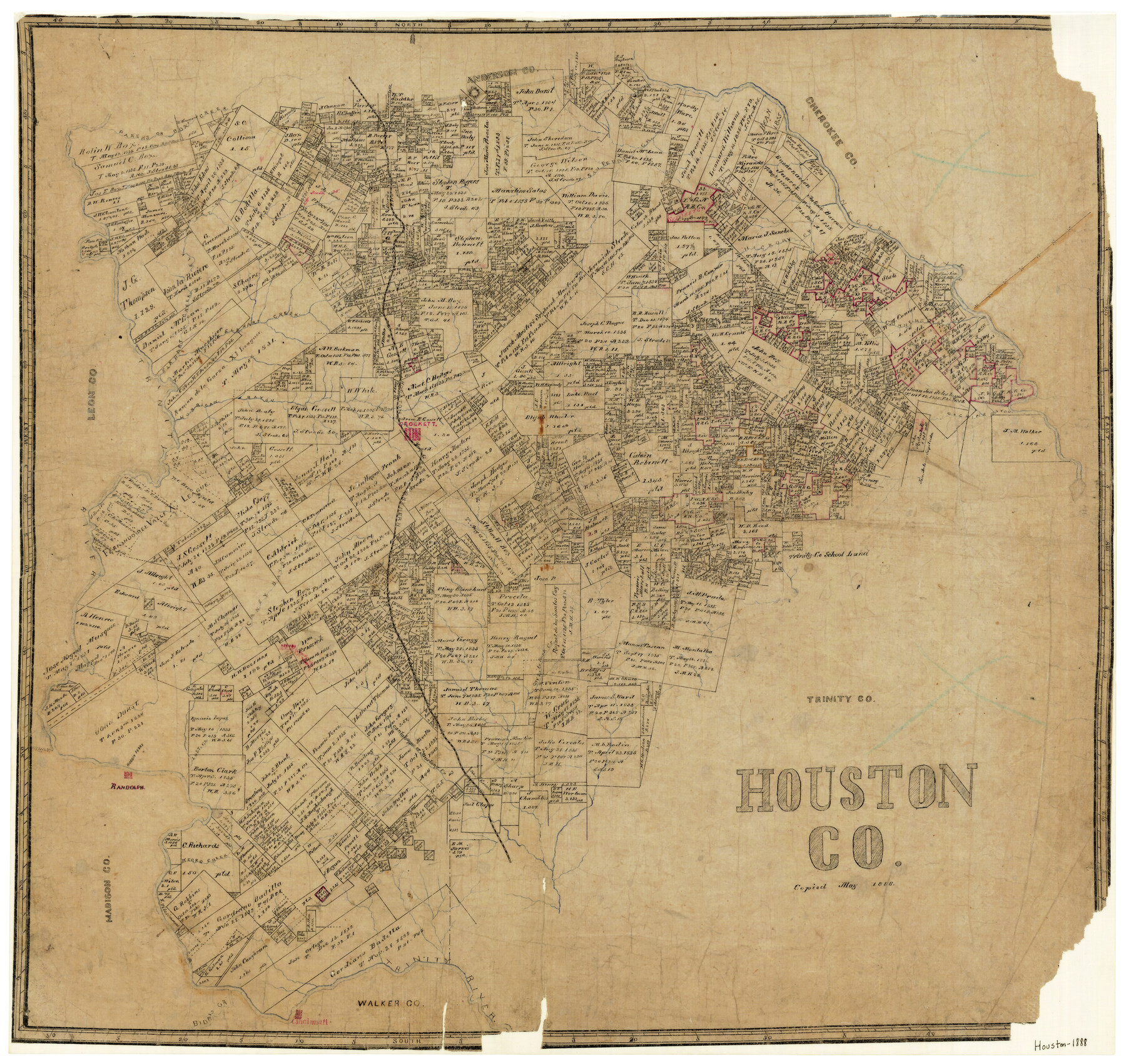
Houston County
-
Map/Doc
3683
-
Collection
General Map Collection
-
Object Dates
5/1888 (Creation Date)
-
People and Organizations
Texas General Land Office (Publisher)
-
Counties
Houston
-
Subjects
County
-
Height x Width
24.5 x 26.1 inches
62.2 x 66.3 cm
-
Comments
Copied in May 1888.
-
Features
Cochine Bayou
Elm Creek
Cincinnati
Bidays Creek
Negro Creek
Mustang Creek
Cantabogue Creek
Lost Creek
Robbin Ferry
Randolph
Caney Bayou
White Rock Creek
Parers [sic] Creek
Hurrican [sic] Bayou
Gossett's Creek
Trinity River
Elkhart Creek
Crockett
H&GN
Hickory Creek
Conners Creek
Neches River
San Pedro Creek
Box Creek
Part of: General Map Collection
Jeff Davis County Sketch File 25

Print $32.00
- Digital $50.00
Jeff Davis County Sketch File 25
1886
Size 11.3 x 8.5 inches
Map/Doc 27992
Uvalde County Working Sketch 65

Print $20.00
- Digital $50.00
Uvalde County Working Sketch 65
Size 34.8 x 43.0 inches
Map/Doc 69696
Refugio County Sketch File 19

Print $20.00
- Digital $50.00
Refugio County Sketch File 19
1916
Size 35.0 x 16.1 inches
Map/Doc 12247
Sutton County Working Sketch 6

Print $20.00
- Digital $50.00
Sutton County Working Sketch 6
1972
Size 39.3 x 37.4 inches
Map/Doc 62349
Refugio County Sketch File 25

Print $6.00
- Digital $50.00
Refugio County Sketch File 25
1915
Size 14.5 x 6.4 inches
Map/Doc 35289
Dimmit County Working Sketch 26

Print $20.00
- Digital $50.00
Dimmit County Working Sketch 26
1956
Size 19.3 x 15.9 inches
Map/Doc 68687
Crane County Sketch File 12

Print $6.00
- Digital $50.00
Crane County Sketch File 12
1901
Size 16.4 x 8.6 inches
Map/Doc 19571
Montague County Rolled Sketch 2

Print $20.00
- Digital $50.00
Montague County Rolled Sketch 2
1940
Size 32.5 x 35.5 inches
Map/Doc 9525
Grayson County Fannin District

Print $20.00
- Digital $50.00
Grayson County Fannin District
1885
Size 40.1 x 37.7 inches
Map/Doc 4961
Concho County

Print $40.00
- Digital $50.00
Concho County
1947
Size 48.1 x 37.3 inches
Map/Doc 95464

Flight Mission No. CGI-4N, Frame 195, Cameron County

Print $20.00
- Digital $50.00
Flight Mission No. CGI-4N, Frame 195, Cameron County
1955
Size 18.5 x 22.3 inches
Map/Doc 84698
You may also like
Val Verde County Sketch File 54

Print $6.00
- Digital $50.00
Val Verde County Sketch File 54
1940
Size 11.3 x 8.9 inches
Map/Doc 39334
Leon County Working Sketch 9

Print $20.00
- Digital $50.00
Leon County Working Sketch 9
1949
Size 16.7 x 18.1 inches
Map/Doc 70408
Hunt County Sketch File 16b

Print $6.00
- Digital $50.00
Hunt County Sketch File 16b
Size 6.7 x 7.4 inches
Map/Doc 27111
Brazoria County NRC Article 33.136 Sketch 19

Print $28.00
- Digital $50.00
Brazoria County NRC Article 33.136 Sketch 19
2018
Size 18.0 x 24.0 inches
Map/Doc 95376
Polk County Sketch File 25

Print $46.00
- Digital $50.00
Polk County Sketch File 25
Size 5.7 x 28.2 inches
Map/Doc 34176

Calhoun County

Print $20.00
- Digital $50.00
Calhoun County
1883
Size 22.9 x 19.1 inches
Map/Doc 66741
Brewster County Rolled Sketch 45

Print $20.00
- Digital $50.00
Brewster County Rolled Sketch 45
1921
Size 20.3 x 15.6 inches
Map/Doc 5221
Polk County Working Sketch 26

Print $20.00
- Digital $50.00
Polk County Working Sketch 26
1958
Size 19.0 x 24.8 inches
Map/Doc 71642
Starr County Boundary File 99

Print $56.00
- Digital $50.00
Starr County Boundary File 99
Size 9.2 x 6.2 inches
Map/Doc 58846
Nueces County Rolled Sketch 48

Print $20.00
- Digital $50.00
Nueces County Rolled Sketch 48
1957
Size 33.1 x 45.1 inches
Map/Doc 6887
Robertson County Working Sketch 14

Print $40.00
- Digital $50.00
Robertson County Working Sketch 14
1988
Size 48.6 x 39.6 inches
Map/Doc 63587