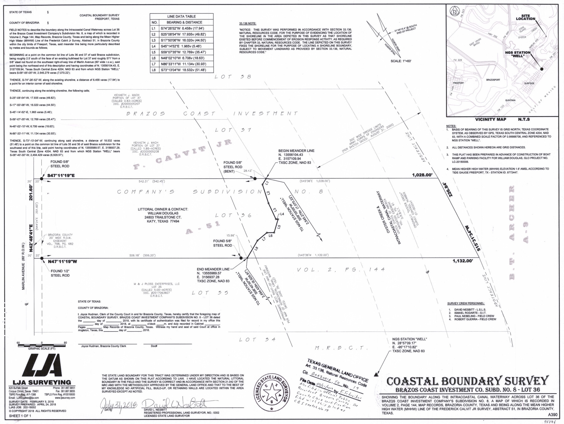
Brazoria County NRC Article 33.136 Sketch 19
Coastal Boundary Survey - Brazos Coast Investment Co. Subd. No. 8 - Lot 36
-
Map/Doc
95376
-
Collection
General Map Collection
-
Object Dates
2018/7/31 (Creation Date)
2018/2/5 (Survey Date)
2019/3/21 (File Date)
-
People and Organizations
David L. Nesbitt (Surveyor/Engineer)
-
Counties
Brazoria
-
Subjects
Surveying CBS
-
Height x Width
18.0 x 24.0 inches
45.7 x 61.0 cm
-
Medium
multi-page, multi-format
-
Comments
Project: William Douglas Boat Ramp Facility Project No.: LC-20180006 (GLO)
Part of: General Map Collection
Garza County Sketch File 3

Print $20.00
- Digital $50.00
Garza County Sketch File 3
1879
Size 18.6 x 17.6 inches
Map/Doc 11544
Travis County Working Sketch 46

Print $20.00
- Digital $50.00
Travis County Working Sketch 46
1981
Size 46.6 x 36.9 inches
Map/Doc 69430
Uvalde County Working Sketch 56

Print $20.00
- Digital $50.00
Uvalde County Working Sketch 56
1985
Size 44.8 x 40.6 inches
Map/Doc 72126
Galveston County Rolled Sketch 29

Print $104.00
- Digital $50.00
Galveston County Rolled Sketch 29
Size 10.1 x 15.3 inches
Map/Doc 45147
Cottle County Sketch File A and B

Print $27.00
- Digital $50.00
Cottle County Sketch File A and B
Size 18.4 x 24.1 inches
Map/Doc 11200
Kerr County Boundary File 1

Print $4.00
- Digital $50.00
Kerr County Boundary File 1
Size 12.7 x 8.1 inches
Map/Doc 55982
Menard County Boundary File 10

Print $4.00
- Digital $50.00
Menard County Boundary File 10
Size 14.2 x 8.7 inches
Map/Doc 57096
Wise County Sketch File 49

Print $20.00
- Digital $50.00
Wise County Sketch File 49
1882
Size 15.5 x 20.8 inches
Map/Doc 12702
Nacogdoches County

Print $40.00
- Digital $50.00
Nacogdoches County
1950
Size 48.1 x 44.1 inches
Map/Doc 95598
Duval County Rolled Sketch 44

Print $40.00
- Digital $50.00
Duval County Rolled Sketch 44
1981
Size 36.5 x 90.5 inches
Map/Doc 8821
Callahan County Sketch File 6

Print $42.00
- Digital $50.00
Callahan County Sketch File 6
1858
Size 8.2 x 6.4 inches
Map/Doc 35859
Travis County Working Sketch 52

Print $20.00
- Digital $50.00
Travis County Working Sketch 52
1985
Size 28.2 x 10.0 inches
Map/Doc 69436
You may also like
Hill County Working Sketch 5

Print $20.00
- Digital $50.00
Hill County Working Sketch 5
2008
Size 32.2 x 31.6 inches
Map/Doc 89013
Culberson County Sketch File 3a

Print $3.00
- Digital $50.00
Culberson County Sketch File 3a
1879
Size 8.0 x 16.7 inches
Map/Doc 20122
Map of Colorado County

Print $20.00
- Digital $50.00
Map of Colorado County
1871
Size 18.0 x 18.8 inches
Map/Doc 3425
Knox County Boundary File 2

Print $40.00
- Digital $50.00
Knox County Boundary File 2
Size 31.1 x 34.1 inches
Map/Doc 65017
The Republic County of Shelby. January 16, 1843

Print $20.00
The Republic County of Shelby. January 16, 1843
2020
Size 20.0 x 21.7 inches
Map/Doc 96285
Rusk County Sketch File 19a

Print $4.00
Rusk County Sketch File 19a
1860
Size 8.2 x 6.6 inches
Map/Doc 35528
Upton County Rolled Sketch 25

Print $20.00
- Digital $50.00
Upton County Rolled Sketch 25
1941
Size 33.2 x 34.5 inches
Map/Doc 10044
Yoakum County Rolled Sketch 3(2)

Print $40.00
- Digital $50.00
Yoakum County Rolled Sketch 3(2)
1959
Size 12.7 x 128.8 inches
Map/Doc 10163
Hopkins County Boundary File 1

Print $26.00
- Digital $50.00
Hopkins County Boundary File 1
Size 12.3 x 7.9 inches
Map/Doc 55044
Presidio County Sketch File 62A

Print $20.00
- Digital $50.00
Presidio County Sketch File 62A
Size 14.6 x 20.8 inches
Map/Doc 11717

[Sketch showing G. & M. Block M-20, Sections 29-46]
![91706, [Sketch showing G. & M. Block M-20, Sections 29-46], Twichell Survey Records](https://historictexasmaps.com/wmedia_w700/maps/91706-1.tif.jpg)
Print $2.00
- Digital $50.00
[Sketch showing G. & M. Block M-20, Sections 29-46]
Size 6.7 x 13.4 inches
Map/Doc 91706