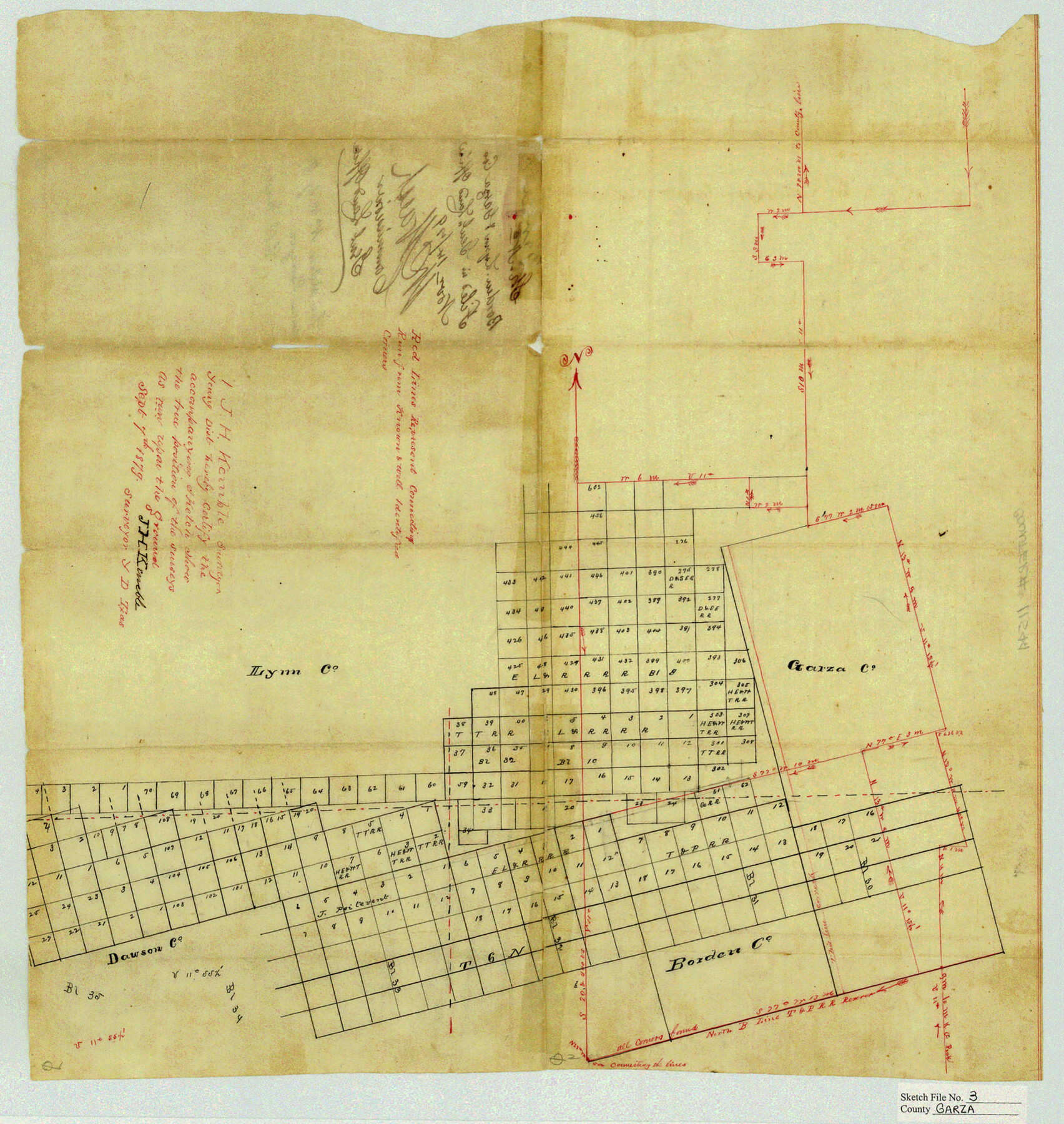
Garza County Sketch File 3
Borden, Lynn & Garza Cos.
-
Map/Doc
11544
-
Collection
General Map Collection
-
Object Dates
1879/9/7 (Creation Date)
1879/11/14 (File Date)
-
People and Organizations
J.H. Kemble (Surveyor/Engineer)
-
Counties
Garza Lynn Dawson Borden
-
Subjects
Surveying Sketch File
-
Height x Width
18.6 x 17.6 inches
47.2 x 44.7 cm
-
Medium
paper, manuscript
Part of: General Map Collection
Orange County Working Sketch 16

Print $20.00
- Digital $50.00
Orange County Working Sketch 16
1929
Size 25.0 x 24.2 inches
Map/Doc 71348
Crane County Rolled Sketch 18

Print $20.00
- Digital $50.00
Crane County Rolled Sketch 18
1950
Size 37.8 x 37.2 inches
Map/Doc 8683
Potter County Rolled Sketch 5

Print $40.00
- Digital $50.00
Potter County Rolled Sketch 5
1903
Size 56.0 x 21.9 inches
Map/Doc 9759
Terrell County Rolled Sketch 43

Print $20.00
- Digital $50.00
Terrell County Rolled Sketch 43
1950
Size 27.5 x 36.4 inches
Map/Doc 7946
Fractional Township No. 7 South Range No. 16 East of the Indian Meridian, Indian Territory

Print $20.00
- Digital $50.00
Fractional Township No. 7 South Range No. 16 East of the Indian Meridian, Indian Territory
1897
Size 19.2 x 24.2 inches
Map/Doc 75229
Flight Mission No. DCL-6C, Frame 115, Kenedy County

Print $20.00
- Digital $50.00
Flight Mission No. DCL-6C, Frame 115, Kenedy County
1943
Size 18.5 x 22.4 inches
Map/Doc 85945
Flight Mission No. CRC-5R, Frame 26, Chambers County

Print $20.00
- Digital $50.00
Flight Mission No. CRC-5R, Frame 26, Chambers County
1956
Size 18.6 x 22.5 inches
Map/Doc 84948
Webb County Rolled Sketch 21

Print $20.00
- Digital $50.00
Webb County Rolled Sketch 21
1930
Size 32.9 x 23.0 inches
Map/Doc 8183
Travis County Rolled Sketch 24

Print $20.00
- Digital $50.00
Travis County Rolled Sketch 24
1942
Size 15.3 x 16.1 inches
Map/Doc 8025
McMullen County Sketch File 22

Print $4.00
- Digital $50.00
McMullen County Sketch File 22
Size 10.0 x 8.1 inches
Map/Doc 31377

Nueces County Aerial Photograph Index Sheet 5

Print $20.00
- Digital $50.00
Nueces County Aerial Photograph Index Sheet 5
1956
Size 19.5 x 23.4 inches
Map/Doc 83738
You may also like
[H. & T. C. RR. Company, Block 47 and Vicinity]
![91413, [H. & T. C. RR. Company, Block 47 and Vicinity], Twichell Survey Records](https://historictexasmaps.com/wmedia_w700/maps/91413-1.tif.jpg)
Print $20.00
- Digital $50.00
[H. & T. C. RR. Company, Block 47 and Vicinity]
Size 18.8 x 13.6 inches
Map/Doc 91413
Presidio County Rolled Sketch 93A

Print $20.00
- Digital $50.00
Presidio County Rolled Sketch 93A
Size 29.6 x 28.2 inches
Map/Doc 7379
Map representing the surveys made in Bexar County

Print $40.00
- Digital $50.00
Map representing the surveys made in Bexar County
1839
Size 76.0 x 68.4 inches
Map/Doc 1947
Trinity River, Extension Crab Tree Ferry Sheet/Red Oak Sheet

Print $4.00
- Digital $50.00
Trinity River, Extension Crab Tree Ferry Sheet/Red Oak Sheet
1922
Size 17.5 x 25.4 inches
Map/Doc 65187
Floyd County Working Sketch 6

Print $20.00
- Digital $50.00
Floyd County Working Sketch 6
1965
Size 22.9 x 31.3 inches
Map/Doc 69185
[Missouri, Kansas & Texas] E. L. & R. R. Railroad, Morris Co.
![64273, [Missouri, Kansas & Texas] E. L. & R. R. Railroad, Morris Co., General Map Collection](https://historictexasmaps.com/wmedia_w700/maps/64273.tif.jpg)
Print $20.00
- Digital $50.00
[Missouri, Kansas & Texas] E. L. & R. R. Railroad, Morris Co.
1906
Size 13.1 x 28.4 inches
Map/Doc 64273
Kent County Working Sketch 12

Print $20.00
- Digital $50.00
Kent County Working Sketch 12
1953
Size 33.8 x 24.3 inches
Map/Doc 70019
Wheeler County Sketch File 3

Print $24.00
- Digital $50.00
Wheeler County Sketch File 3
1881
Size 12.9 x 8.4 inches
Map/Doc 39998
Map showing Center Lines on Holley St.

Print $3.00
- Digital $50.00
Map showing Center Lines on Holley St.
1912
Size 6.1 x 17.5 inches
Map/Doc 495
City of Round Rock, Texas

Print $20.00
City of Round Rock, Texas
1958
Size 25.3 x 31.5 inches
Map/Doc 87359
Hudspeth County Working Sketch 43

Print $40.00
- Digital $50.00
Hudspeth County Working Sketch 43
1981
Size 37.4 x 53.7 inches
Map/Doc 66328
Goliad County Sketch File 37

Print $4.00
- Digital $50.00
Goliad County Sketch File 37
1850
Size 10.2 x 8.3 inches
Map/Doc 24336