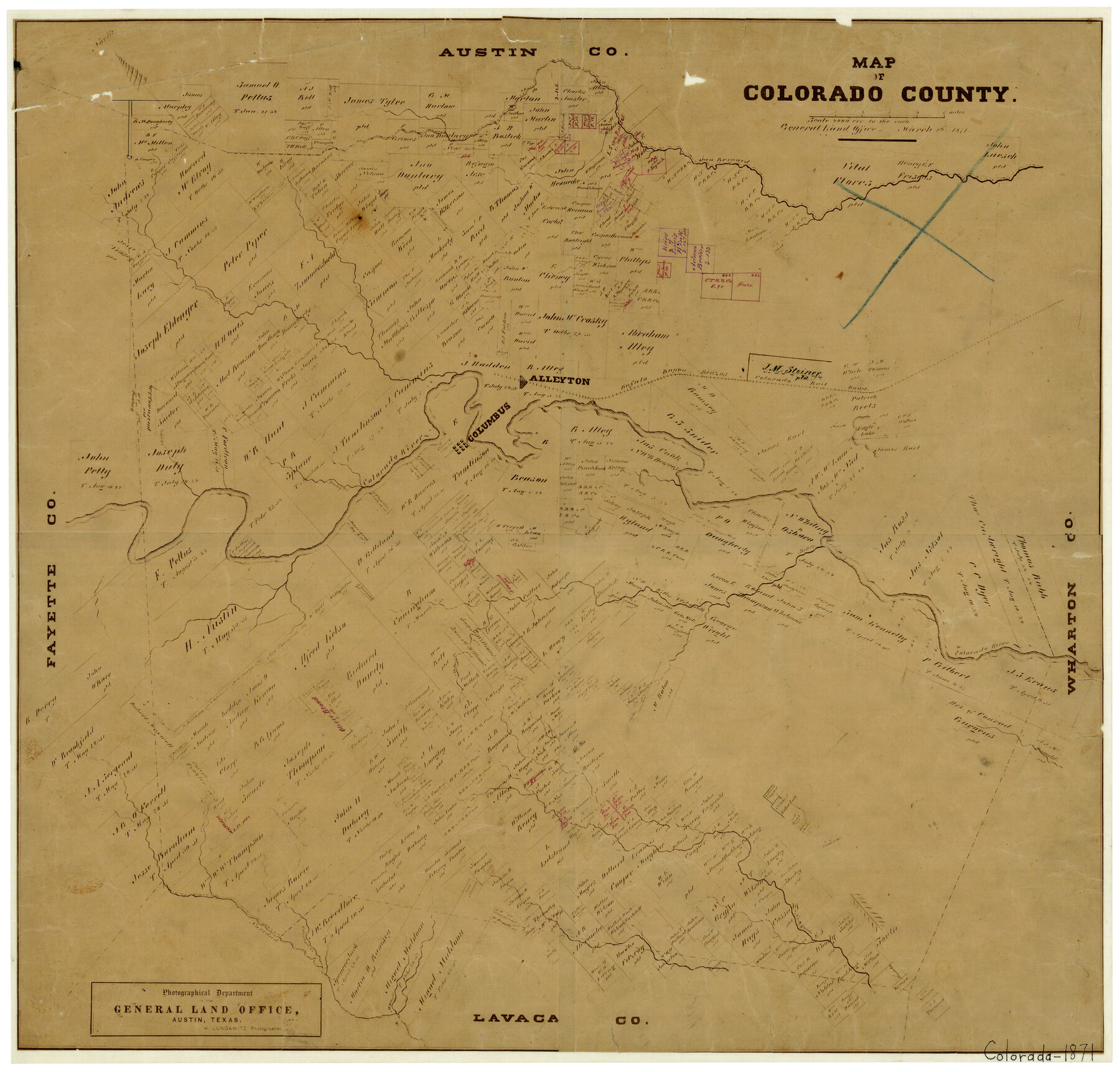
Map of Colorado County
-
Map/Doc
3425
-
Collection
General Map Collection
-
Object Dates
3/16/1871 (Creation Date)
-
People and Organizations
Herman Lungkwitz (Draftsman)
-
Counties
Colorado
-
Subjects
County
-
Height x Width
18.0 x 18.8 inches
45.7 x 47.8 cm
-
Features
Eagle Lake
Honey Creek
Prairie Creek
Navidad River
Waterhole Creek
South Sandy Creek
Sandy Creek
Miller's Creek
Skull Creek
San Bernard River
Colorado River
Rocky Creek
Crier Creek
Cummings Creek
Columbus
Alleyton
BBB&C
Part of: General Map Collection
Edwards County Working Sketch 22

Print $20.00
- Digital $50.00
Edwards County Working Sketch 22
1938
Size 15.3 x 18.5 inches
Map/Doc 68898
Val Verde Co.

Print $20.00
- Digital $50.00
Val Verde Co.
1908
Size 42.4 x 38.7 inches
Map/Doc 16912
[Galveston, Harrisburg & San Antonio Railway]
![64403, [Galveston, Harrisburg & San Antonio Railway], General Map Collection](https://historictexasmaps.com/wmedia_w700/maps/64403.tif.jpg)
Print $20.00
- Digital $50.00
[Galveston, Harrisburg & San Antonio Railway]
1892
Size 13.7 x 33.7 inches
Map/Doc 64403
El Paso County Sketch File 30

Print $4.00
- Digital $50.00
El Paso County Sketch File 30
1960
Size 11.2 x 8.8 inches
Map/Doc 22082
Matagorda County Rolled Sketch 30

Print $20.00
- Digital $50.00
Matagorda County Rolled Sketch 30
1937
Size 24.9 x 35.0 inches
Map/Doc 6693
Tom Green County Sketch File 74

Print $6.00
- Digital $50.00
Tom Green County Sketch File 74
1950
Size 11.3 x 8.9 inches
Map/Doc 38250

Edwards County Sketch File ABC

Print $12.00
- Digital $50.00
Edwards County Sketch File ABC
1913
Size 14.5 x 9.1 inches
Map/Doc 21662
Intracoastal Waterway in Texas - Corpus Christi to Point Isabel including Arroyo Colorado to Mo. Pac. R.R. Bridge Near Harlingen

Print $20.00
- Digital $50.00
Intracoastal Waterway in Texas - Corpus Christi to Point Isabel including Arroyo Colorado to Mo. Pac. R.R. Bridge Near Harlingen
1933
Size 28.1 x 41.2 inches
Map/Doc 61845
Val Verde County Working Sketch 83

Print $40.00
- Digital $50.00
Val Verde County Working Sketch 83
1973
Size 28.7 x 53.6 inches
Map/Doc 72218

Limestone County Sketch File 14

Print $4.00
- Digital $50.00
Limestone County Sketch File 14
1883
Size 10.7 x 8.2 inches
Map/Doc 30179
You may also like
Martin County Rolled Sketch 10A

Print $20.00
- Digital $50.00
Martin County Rolled Sketch 10A
1994
Size 18.3 x 24.5 inches
Map/Doc 6671
Tarrant County Sketch File 36

Print $56.00
- Digital $50.00
Tarrant County Sketch File 36
2018
Size 11.0 x 8.5 inches
Map/Doc 95395
Nueces County Rolled Sketch 106

Print $104.00
Nueces County Rolled Sketch 106
1986
Size 18.2 x 24.6 inches
Map/Doc 7097
General Highway Map, Henderson County, Texas

Print $20.00
General Highway Map, Henderson County, Texas
1961
Size 24.9 x 18.0 inches
Map/Doc 79517
Rusk County Working Sketch 32

Print $20.00
- Digital $50.00
Rusk County Working Sketch 32
1919
Size 16.7 x 17.1 inches
Map/Doc 63669
[Section of] El Nuevo Mexico y Tierras Adyacentes Mapa Levantado para la demarcacion de los Limites de los Dominios Españoles y de los Estados Unidos

[Section of] El Nuevo Mexico y Tierras Adyacentes Mapa Levantado para la demarcacion de los Limites de los Dominios Españoles y de los Estados Unidos
1811
Size 17.9 x 26.7 inches
Map/Doc 97484
Bailey County Working Sketch 4

Print $20.00
- Digital $50.00
Bailey County Working Sketch 4
1937
Size 27.0 x 32.0 inches
Map/Doc 67591
[Leagues 464-467]
![91555, [Leagues 464-467], Twichell Survey Records](https://historictexasmaps.com/wmedia_w700/maps/91555-1.tif.jpg)
Print $20.00
- Digital $50.00
[Leagues 464-467]
Size 19.4 x 15.1 inches
Map/Doc 91555
General Highway Map, Nueces County, Texas

Print $20.00
General Highway Map, Nueces County, Texas
1940
Size 24.6 x 18.5 inches
Map/Doc 79209
Flight Mission No. DIX-8P, Frame 67, Aransas County

Print $20.00
- Digital $50.00
Flight Mission No. DIX-8P, Frame 67, Aransas County
1956
Size 18.7 x 22.4 inches
Map/Doc 83898
Webb County Boundary File 2

Print $12.00
- Digital $50.00
Webb County Boundary File 2
Size 11.3 x 8.7 inches
Map/Doc 59710
Fort Bend County State Real Property Sketch 6

Print $40.00
- Digital $50.00
Fort Bend County State Real Property Sketch 6
1986
Size 34.9 x 43.6 inches
Map/Doc 61680