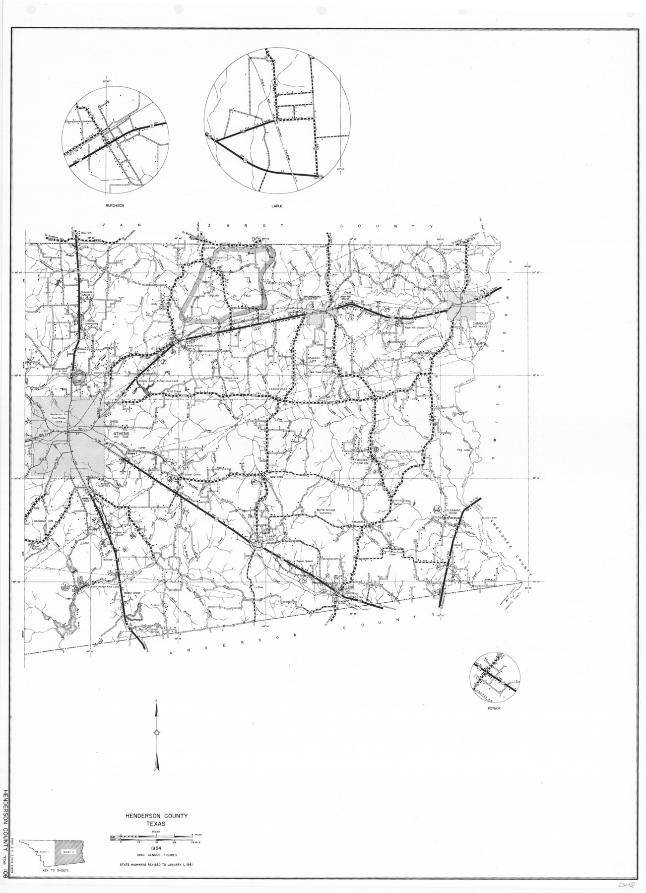
General Highway Map, Henderson County, Texas
-
Map/Doc
79517
-
Collection
Texas State Library and Archives
-
Object Dates
1961 (Creation Date)
-
People and Organizations
Texas State Highway Department (Publisher)
-
Counties
Henderson
-
Subjects
County
-
Height x Width
24.9 x 18.0 inches
63.3 x 45.7 cm
-
Comments
Prints available courtesy of the Texas State Library and Archives.
More info can be found here: TSLAC Map 05172
Part of: Texas State Library and Archives
General Highway Map, Dawson County, Texas

Print $20.00
General Highway Map, Dawson County, Texas
1940
Size 18.5 x 25.2 inches
Map/Doc 79071
General Highway Map, Lamb County, Texas

Print $20.00
General Highway Map, Lamb County, Texas
1961
Size 24.5 x 18.2 inches
Map/Doc 79562
General Highway Map, Gaines County, Texas

Print $20.00
General Highway Map, Gaines County, Texas
1961
Size 24.6 x 18.1 inches
Map/Doc 79474
General Highway Map, Hansford County, Texas

Print $20.00
General Highway Map, Hansford County, Texas
1940
Size 18.4 x 25.0 inches
Map/Doc 79112
Greenville, Hunt County, Texas

Print $20.00
Greenville, Hunt County, Texas
1891
Size 21.9 x 36.5 inches
Map/Doc 79749
Texas and part of Mexico and the United States showing the Route of the First Santa Fe Expedition

Print $20.00
Texas and part of Mexico and the United States showing the Route of the First Santa Fe Expedition
1844
Size 20.3 x 15.8 inches
Map/Doc 79730
General Highway Map, Floyd County, Texas

Print $20.00
General Highway Map, Floyd County, Texas
1940
Size 25.1 x 18.7 inches
Map/Doc 79091
General Highway Map, Gonzales County, Texas

Print $20.00
General Highway Map, Gonzales County, Texas
1961
Size 18.2 x 24.7 inches
Map/Doc 79482
General Highway Map, Midland County, Texas

Print $20.00
General Highway Map, Midland County, Texas
1940
Size 18.2 x 24.5 inches
Map/Doc 79197
General Highway Map, Lee County, Texas

Print $20.00
General Highway Map, Lee County, Texas
1961
Size 18.4 x 24.6 inches
Map/Doc 79567
Mapa de los Estados Unidos Mejicanos

Print $20.00
Mapa de los Estados Unidos Mejicanos
1831
Size 24.7 x 29.7 inches
Map/Doc 79291
Rand McNally Standard Map of Texas

Print $20.00
Rand McNally Standard Map of Texas
1923
Size 27.6 x 40.3 inches
Map/Doc 76261
You may also like
Hood County Working Sketch 5

Print $20.00
- Digital $50.00
Hood County Working Sketch 5
1968
Size 20.7 x 29.1 inches
Map/Doc 66199
General Highway Map, Dawson County, Texas
Print $20.00
General Highway Map, Dawson County, Texas
1940
Size 18.5 x 25.2 inches
Map/Doc 79071
County of Galveston, Texas

Print $20.00
- Digital $50.00
County of Galveston, Texas
1845
Size 22.9 x 32.2 inches
Map/Doc 3574
Grayson County Sketch File 22

Print $4.00
- Digital $50.00
Grayson County Sketch File 22
1871
Size 10.4 x 8.4 inches
Map/Doc 24501
Louisiana and Texas Intracoastal Waterway

Print $20.00
- Digital $50.00
Louisiana and Texas Intracoastal Waterway
1937
Size 13.7 x 19.6 inches
Map/Doc 83348
Wise County Sketch File 11

Print $4.00
- Digital $50.00
Wise County Sketch File 11
1860
Size 12.8 x 8.0 inches
Map/Doc 40544
Hardin County Working Sketch 34

Print $20.00
- Digital $50.00
Hardin County Working Sketch 34
1980
Size 15.7 x 12.1 inches
Map/Doc 63432
Flight Mission No. CGI-3N, Frame 146, Cameron County

Print $20.00
- Digital $50.00
Flight Mission No. CGI-3N, Frame 146, Cameron County
1954
Size 18.5 x 22.1 inches
Map/Doc 84619
Pecos County Rolled Sketch Q

Print $20.00
- Digital $50.00
Pecos County Rolled Sketch Q
Size 18.7 x 12.2 inches
Map/Doc 7311
Galveston County NRC Article 33.136 Sketch 32

Print $26.00
- Digital $50.00
Galveston County NRC Article 33.136 Sketch 32
2005
Size 24.5 x 36.8 inches
Map/Doc 83173
[Capitol Leagues 217- 235, 238, and 239]
![90706, [Capitol Leagues 217- 235, 238, and 239], Twichell Survey Records](https://historictexasmaps.com/wmedia_w700/maps/90706-1.tif.jpg)
Print $20.00
- Digital $50.00
[Capitol Leagues 217- 235, 238, and 239]
Size 26.3 x 26.9 inches
Map/Doc 90706
Collingsworth County Working Sketch Graphic Index

Print $20.00
- Digital $50.00
Collingsworth County Working Sketch Graphic Index
1971
Size 41.0 x 34.8 inches
Map/Doc 76499