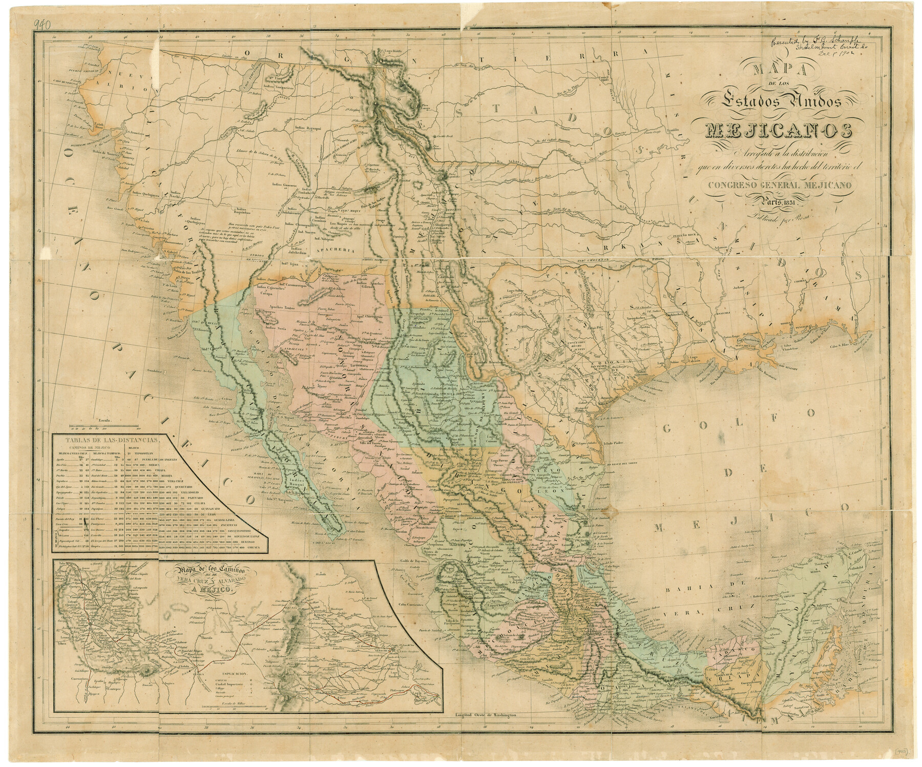
Mapa de los Estados Unidos Mejicanos
-
Map/Doc
79291
-
Collection
Texas State Library and Archives
-
Object Dates
[1831 ca.] (Creation Date)
-
Subjects
Mexico
-
Height x Width
24.7 x 29.7 inches
62.7 x 75.4 cm
-
Comments
Prints available courtesy of the Texas State Library and Archives.
More info can be found here: TSLAC Map 00940
Part of: Texas State Library and Archives
General Highway Map, Collingsworth County, Texas

Print $20.00
General Highway Map, Collingsworth County, Texas
1961
Size 18.1 x 24.6 inches
Map/Doc 79415
Preliminary Sketch of Galveston Bay Indicating Proposed Sites for Light Houses

Print $20.00
Preliminary Sketch of Galveston Bay Indicating Proposed Sites for Light Houses
1851
Size 20.7 x 18.0 inches
Map/Doc 76215
Plat of Corpus Christi

Print $20.00
Plat of Corpus Christi
1850
Size 18.0 x 27.2 inches
Map/Doc 76269
General Highway Map. Detail of Cities and Towns in Orange County, Texas [Orange and vicinity]
![79622, General Highway Map. Detail of Cities and Towns in Orange County, Texas [Orange and vicinity], Texas State Library and Archives](https://historictexasmaps.com/wmedia_w700/maps/79622.tif.jpg)
Print $20.00
General Highway Map. Detail of Cities and Towns in Orange County, Texas [Orange and vicinity]
1961
Size 18.1 x 24.4 inches
Map/Doc 79622
General Highway Map, Childress County, Texas

Print $20.00
General Highway Map, Childress County, Texas
1961
Size 18.2 x 24.8 inches
Map/Doc 79408
Topographic Map of Texas and Oklahoma Boundary, Fort Augur Area

Print $20.00
Topographic Map of Texas and Oklahoma Boundary, Fort Augur Area
1924
Size 17.2 x 33.7 inches
Map/Doc 79754
General Highway Map, Fort Bend County, Texas

Print $20.00
General Highway Map, Fort Bend County, Texas
1961
Size 18.1 x 24.5 inches
Map/Doc 79469
General Highway Map, Harrison County, Texas

Print $20.00
General Highway Map, Harrison County, Texas
1961
Size 18.3 x 24.8 inches
Map/Doc 79509
General Highway Map, San Saba County, Texas

Print $20.00
General Highway Map, San Saba County, Texas
1940
Size 18.3 x 24.8 inches
Map/Doc 79238
General Highway Map, Crockett County, Texas

Print $20.00
General Highway Map, Crockett County, Texas
1940
Size 18.3 x 25.1 inches
Map/Doc 79062
General Highway Map, Throckmorton County, Texas

Print $20.00
General Highway Map, Throckmorton County, Texas
1961
Size 18.2 x 24.8 inches
Map/Doc 79676
General Highway Map, Schleicher County, Sutton County, Texas

Print $20.00
General Highway Map, Schleicher County, Sutton County, Texas
1961
Size 18.2 x 24.3 inches
Map/Doc 79649
You may also like
Big Lake Oil Field

Print $20.00
- Digital $50.00
Big Lake Oil Field
1924
Size 27.3 x 19.1 inches
Map/Doc 2420
Map Showing Lands Owned by Capitol Freehold Land and Investment Company, Ltd.

Print $20.00
- Digital $50.00
Map Showing Lands Owned by Capitol Freehold Land and Investment Company, Ltd.
1909
Size 36.4 x 25.2 inches
Map/Doc 90733
Brewster County Working Sketch 50

Print $40.00
- Digital $50.00
Brewster County Working Sketch 50
1950
Size 31.5 x 48.4 inches
Map/Doc 67584
Upton County Working Sketch 58

Print $20.00
- Digital $50.00
Upton County Working Sketch 58
1988
Size 29.1 x 37.8 inches
Map/Doc 69555
Crockett County Working Sketch 18

Print $20.00
- Digital $50.00
Crockett County Working Sketch 18
1919
Size 37.4 x 31.8 inches
Map/Doc 68351
Edwards County Working Sketch 121

Print $20.00
- Digital $50.00
Edwards County Working Sketch 121
1976
Size 28.2 x 24.8 inches
Map/Doc 68997
Preliminary Chart No. 31 of the Sea Coast of the United States from Galveston Bay to Matagorda Bay, Texas

Print $20.00
- Digital $50.00
Preliminary Chart No. 31 of the Sea Coast of the United States from Galveston Bay to Matagorda Bay, Texas
1857
Size 23.3 x 28.1 inches
Map/Doc 69950
Somervell County Working Sketch 6

Print $20.00
- Digital $50.00
Somervell County Working Sketch 6
1992
Size 23.2 x 21.5 inches
Map/Doc 63910
Flight Mission No. DAG-23K, Frame 179, Matagorda County

Print $20.00
- Digital $50.00
Flight Mission No. DAG-23K, Frame 179, Matagorda County
1953
Size 18.5 x 22.4 inches
Map/Doc 86514
General Highway Map Lynn County

Print $20.00
- Digital $50.00
General Highway Map Lynn County
1949
Size 25.8 x 18.8 inches
Map/Doc 92901
Flight Mission No. CGI-3N, Frame 71, Cameron County

Print $20.00
- Digital $50.00
Flight Mission No. CGI-3N, Frame 71, Cameron County
1954
Size 18.4 x 22.3 inches
Map/Doc 84565
San Jacinto County Working Sketch 19

Print $20.00
- Digital $50.00
San Jacinto County Working Sketch 19
1939
Size 25.4 x 25.2 inches
Map/Doc 63732