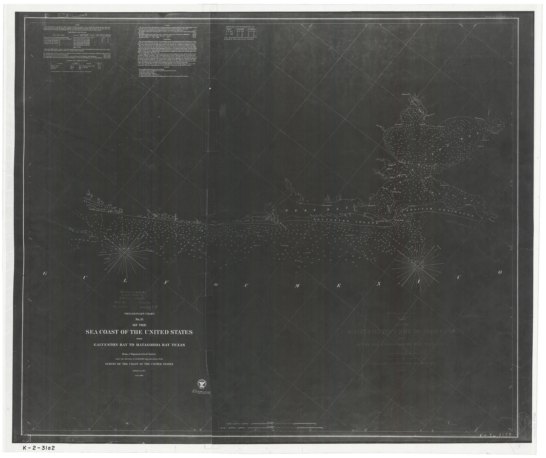
Preliminary Chart No. 31 of the Sea Coast of the United States from Galveston Bay to Matagorda Bay, Texas
K-2-31a1
-
Map/Doc
69950
-
Collection
General Map Collection
-
Object Dates
1857 (Creation Date)
-
Counties
Galveston Brazoria Matagorda Orange
-
Subjects
Nautical Charts
-
Height x Width
23.3 x 28.1 inches
59.2 x 71.4 cm
Part of: General Map Collection
Located Line of the Panhandle & Gulf Ry. through State Lands, Public School and University, in Upton County Texas, Right of Way 200 feet wide

Print $40.00
- Digital $50.00
Located Line of the Panhandle & Gulf Ry. through State Lands, Public School and University, in Upton County Texas, Right of Way 200 feet wide
Size 13.3 x 102.6 inches
Map/Doc 64052
University Land Field Notes for Blocks A, B, C, D, E, F, G, H, I, and J in Hudspeth County

University Land Field Notes for Blocks A, B, C, D, E, F, G, H, I, and J in Hudspeth County
Map/Doc 81712
Ellis County Boundary File 3a

Print $10.00
- Digital $50.00
Ellis County Boundary File 3a
Size 11.2 x 8.9 inches
Map/Doc 52960
Freestone County Sketch File 24

Print $20.00
- Digital $50.00
Freestone County Sketch File 24
1951
Size 23.1 x 17.9 inches
Map/Doc 11517
Scurry County Working Sketch 7

Print $20.00
- Digital $50.00
Scurry County Working Sketch 7
1971
Size 33.5 x 29.0 inches
Map/Doc 63836
Maps & Lists Showing Prison Lands (Oil & Gas) Leased as of June 1955

Digital $50.00
Maps & Lists Showing Prison Lands (Oil & Gas) Leased as of June 1955
Size 11.1 x 8.8 inches
Map/Doc 62873
Val Verde County Working Sketch 48

Print $20.00
- Digital $50.00
Val Verde County Working Sketch 48
1949
Size 32.6 x 17.6 inches
Map/Doc 72183
Map of Shackelford County, Texas

Print $20.00
- Digital $50.00
Map of Shackelford County, Texas
Size 47.3 x 42.8 inches
Map/Doc 78398
Flight Mission No. BQR-3K, Frame 159, Brazoria County

Print $20.00
- Digital $50.00
Flight Mission No. BQR-3K, Frame 159, Brazoria County
1952
Size 18.6 x 22.3 inches
Map/Doc 83986
Map of Starr County

Print $20.00
- Digital $50.00
Map of Starr County
1896
Size 43.7 x 26.9 inches
Map/Doc 4050
[Map of Polk County]
![4613, [Map of Polk County], General Map Collection](https://historictexasmaps.com/wmedia_w700/maps/4613-1.tif.jpg)
Print $20.00
- Digital $50.00
[Map of Polk County]
1855
Size 21.2 x 31.0 inches
Map/Doc 4613
Karnes County Working Sketch 3

Print $20.00
- Digital $50.00
Karnes County Working Sketch 3
1943
Size 34.6 x 31.4 inches
Map/Doc 66651
You may also like
Cooke County Boundary File 2a

Print $8.00
- Digital $50.00
Cooke County Boundary File 2a
Size 12.2 x 7.7 inches
Map/Doc 51849
Harris County Sketch File 13a

Print $4.00
- Digital $50.00
Harris County Sketch File 13a
1860
Size 10.8 x 6.0 inches
Map/Doc 25357
Crane County Rolled Sketch 27

Print $20.00
- Digital $50.00
Crane County Rolled Sketch 27
2020
Size 36.3 x 24.3 inches
Map/Doc 96433
Louisiana and Texas Intracoastal Waterway, Section 7, Galveston Bay to Brazos River and Section 8, Brazos River to Matagorda Bay

Print $20.00
- Digital $50.00
Louisiana and Texas Intracoastal Waterway, Section 7, Galveston Bay to Brazos River and Section 8, Brazos River to Matagorda Bay
1928
Size 31.3 x 42.7 inches
Map/Doc 73063

Subdivision of School Land League 12

Print $2.00
- Digital $50.00
Subdivision of School Land League 12
Size 8.7 x 11.2 inches
Map/Doc 90988
Harris County Rolled Sketch GC

Print $40.00
- Digital $50.00
Harris County Rolled Sketch GC
1917
Size 42.1 x 52.4 inches
Map/Doc 9115
Nueces County Working Sketch 12

Print $20.00
- Digital $50.00
Nueces County Working Sketch 12
2011
Size 22.0 x 42.3 inches
Map/Doc 90047
Webb County Rolled Sketch 9

Print $20.00
- Digital $50.00
Webb County Rolled Sketch 9
1905
Size 12.6 x 16.3 inches
Map/Doc 8175
New Map of the State of Texas Compiled from J. De Cordova's large Map

Print $20.00
- Digital $50.00
New Map of the State of Texas Compiled from J. De Cordova's large Map
1856
Size 17.5 x 27.0 inches
Map/Doc 76172
Upton County Rolled Sketch 50

Print $20.00
- Digital $50.00
Upton County Rolled Sketch 50
1959
Size 20.8 x 32.7 inches
Map/Doc 8085
Montgomery County Working Sketch 6

Print $20.00
- Digital $50.00
Montgomery County Working Sketch 6
1932
Size 24.8 x 32.2 inches
Map/Doc 71112