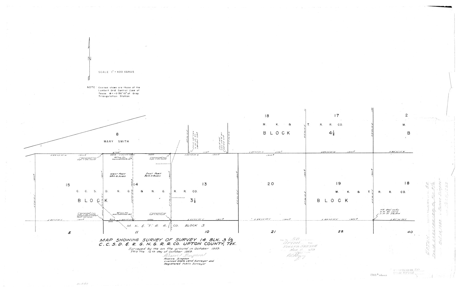
Upton County Rolled Sketch 50
Map showing survey of survey 14, Blk. 3 1/2, C. C. S. D. & R. G. N. G. R.R. Co., Upton County, Tex.
- 
                          Map/Doc8085
- 
                            CollectionGeneral Map Collection
- 
                            Object Dates1959/10/16 (Creation Date)1959/11/5 (File Date)1959 (Survey Date)
- 
                            People and OrganizationsRoscoe Simpson (Surveyor/Engineer)
- 
                            CountiesUpton
- 
                            SubjectsSurveying Rolled Sketch
- 
                            Height x Width20.8 x 32.7 inches52.8 x 83.1 cm
- 
                            Scale1" = 400 varas
Part of: General Map Collection
            Liberty County Working Sketch 53


                                            Print $20.00                    
                                             -                         Digital $50.00                                    
                Liberty County Working Sketch 53
1959
Size 31.1 x 34.4 inches
                                Map/Doc 70513
            
            Aransas County NRC Article 33.136 Location Key Sheet


                                            Print $20.00                    
                                             -                         Digital $50.00                                    
                Aransas County NRC Article 33.136 Location Key Sheet
1971
Size 27.0 x 23.0 inches
                                Map/Doc 88769
            
            Travis County Rolled Sketch 8


                                            Print $20.00                    
                                             -                         Digital $50.00                                    
                Travis County Rolled Sketch 8
1928
Size 30.9 x 24.2 inches
                                Map/Doc 8013
            
            Flight Mission No. BRA-8M, Frame 65, Jefferson County


                                            Print $20.00                    
                                             -                         Digital $50.00                                    
                Flight Mission No. BRA-8M, Frame 65, Jefferson County
1953
Size 18.6 x 22.4 inches
                                Map/Doc 85585
            
            [Surveys along Davidson's Creek]
            
                                    ![243, [Surveys along Davidson's Creek], General Map Collection](https://historictexasmaps.com/wmedia_w700/maps/243.tif.jpg) 


    ![243, [Surveys along Davidson's Creek], General Map Collection](https://historictexasmaps.com/wmedia_w700/maps/243.tif.jpg) 
                                
            
                                            Print $2.00                    
                                             -                         Digital $50.00                                    
                [Surveys along Davidson's Creek]
Size 5.3 x 4.7 inches
                                Map/Doc 243
            
            [Beaumont, Sour Lake and Western Ry. Right of Way and Alignment - Frisco]
            
                                    ![64122, [Beaumont, Sour Lake and Western Ry. Right of Way and Alignment - Frisco], General Map Collection](https://historictexasmaps.com/wmedia_w700/maps/64122.tif.jpg) 


    ![64122, [Beaumont, Sour Lake and Western Ry. Right of Way and Alignment - Frisco], General Map Collection](https://historictexasmaps.com/wmedia_w700/maps/64122.tif.jpg) 
                                
            
                                            Print $20.00                    
                                             -                         Digital $50.00                                    
                [Beaumont, Sour Lake and Western Ry. Right of Way and Alignment - Frisco]
1910
Size 19.8 x 45.9 inches
                                Map/Doc 64122
            
            El Paso County Rolled Sketch EC


                                            Print $20.00                    
                                             -                         Digital $50.00                                    
                El Paso County Rolled Sketch EC
1912
Size 30.1 x 18.2 inches
                                Map/Doc 5857
            
            Live Oak County


                                            Print $40.00                    
                                             -                         Digital $50.00                                    
                Live Oak County
1899
Size 51.5 x 38.4 inches
                                Map/Doc 5018
            
            Rusk County Working Sketch 35


                                            Print $20.00                    
                                             -                         Digital $50.00                                    
                Rusk County Working Sketch 35
2005
Size 28.7 x 42.0 inches
                                Map/Doc 83584
            
            Presidio County Rolled Sketch 95


                                            Print $20.00                    
                                             -                         Digital $50.00                                    
                Presidio County Rolled Sketch 95
1949
Size 45.4 x 37.5 inches
                                Map/Doc 9781
            
            Lipscomb County Boundary File 2


                                            Print $6.00                    
                                             -                         Digital $50.00                                    
                Lipscomb County Boundary File 2
Size 11.1 x 8.6 inches
                                Map/Doc 56315
            
            Map of the Reconnaissance in Texas by Lieuts Blake & Meade of the Corps of Topl. Engrs.


                                            Print $20.00                    
                                             -                         Digital $50.00                                    
                Map of the Reconnaissance in Texas by Lieuts Blake & Meade of the Corps of Topl. Engrs.
1845
Size 27.7 x 18.5 inches
                                Map/Doc 72892
            You may also like
            Williamson County Rolled Sketch 3


                                            Print $20.00                    
                                             -                         Digital $50.00                                    
                Williamson County Rolled Sketch 3
1915
Size 40.1 x 30.9 inches
                                Map/Doc 8261
            
            Map of Austin's Little Colony


                                            Print $20.00                    
                                             -                         Digital $50.00                                    
                Map of Austin's Little Colony
Size 19.0 x 23.6 inches
                                Map/Doc 76008
            
            Travis County Appraisal District Plat Map 2_2011


                                            Print $20.00                    
                                             -                         Digital $50.00                                    
                Travis County Appraisal District Plat Map 2_2011
Size 21.4 x 26.4 inches
                                Map/Doc 94211
            
            [Surveys in the Bexar District along the Sabinal River and Rancheros Creek]
            
                                    ![95, [Surveys in the Bexar District along the Sabinal River and Rancheros Creek], General Map Collection](https://historictexasmaps.com/wmedia_w700/maps/95.tif.jpg) 


    ![95, [Surveys in the Bexar District along the Sabinal River and Rancheros Creek], General Map Collection](https://historictexasmaps.com/wmedia_w700/maps/95.tif.jpg) 
                                
            
                                            Print $2.00                    
                                             -                         Digital $50.00                                    
                [Surveys in the Bexar District along the Sabinal River and Rancheros Creek]
1846
Size 8.6 x 7.8 inches
                                Map/Doc 95
            
            Presidio County Sketch File 35B


                                            Print $20.00                    
                                             -                         Digital $50.00                                    
                Presidio County Sketch File 35B
1906
Size 11.8 x 20.7 inches
                                Map/Doc 11714
            
            McMullen County Working Sketch 13


                                            Print $20.00                    
                                             -                         Digital $50.00                                    
                McMullen County Working Sketch 13
1938
Size 27.2 x 21.6 inches
                                Map/Doc 70714
            
            [Sketch of Surveys in Crockett County, Texas]
            
                                    ![10778, [Sketch of Surveys in Crockett County, Texas], Maddox Collection](https://historictexasmaps.com/wmedia_w700/maps/10778.tif.jpg) 


    ![10778, [Sketch of Surveys in Crockett County, Texas], Maddox Collection](https://historictexasmaps.com/wmedia_w700/maps/10778.tif.jpg) 
                                
            
                                            Print $20.00                    
                                             -                         Digital $50.00                                    
                [Sketch of Surveys in Crockett County, Texas]
1880
Size 21.9 x 12.8 inches
                                Map/Doc 10778
            
            Erath County Working Sketch 19


                                            Print $20.00                    
                                             -                         Digital $50.00                                    
                Erath County Working Sketch 19
1963
Size 30.1 x 27.6 inches
                                Map/Doc 69100
            
            Old Miscellaneous File 38


                                            Print $40.00                    
                                             -                         Digital $50.00                                    
                Old Miscellaneous File 38
1841
Size 57.8 x 33.9 inches
                                Map/Doc 75282
            
            Brewster County Rolled Sketch 15


                                            Print $20.00                    
                                             -                         Digital $50.00                                    
                Brewster County Rolled Sketch 15
1889
Size 32.8 x 26.4 inches
                                Map/Doc 5194
            
            Castro County Rolled Sketch 12


                                            Print $20.00                    
                                             -                         Digital $50.00                                    
                Castro County Rolled Sketch 12
1945
Size 25.7 x 15.8 inches
                                Map/Doc 5421
             
                        