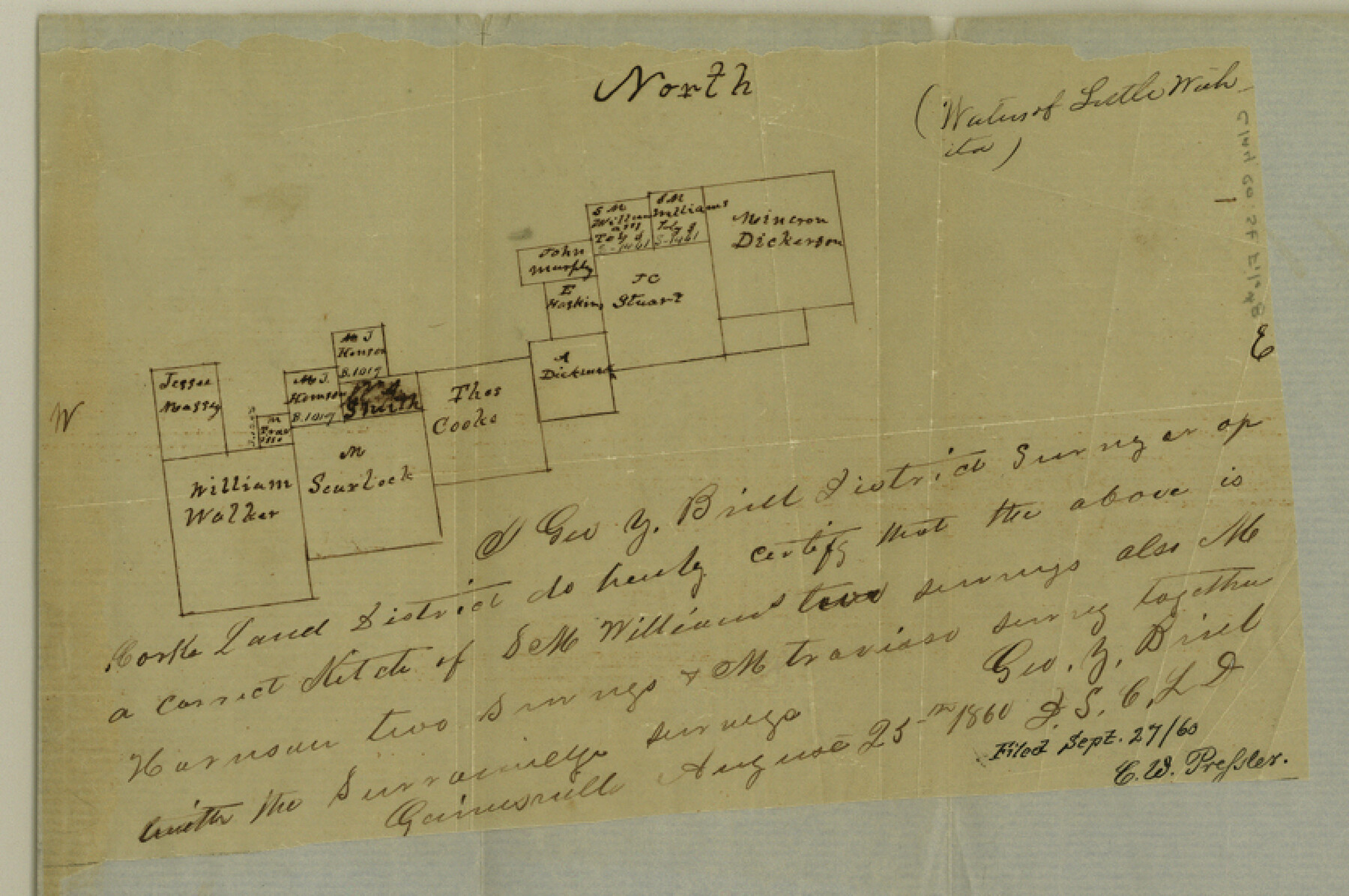
Clay County Sketch File 8
[Sketch of surveys on the waters of Little Wichita, around the J.C. Stuart survey west of Henrietta]
-
Map/Doc
18398
-
Collection
General Map Collection
-
Object Dates
1860/8/25 (Creation Date)
1860/9/27 (File Date)
-
People and Organizations
Geo. Y. Bird (Surveyor/Engineer)
-
Counties
Clay
-
Subjects
Surveying Sketch File
-
Height x Width
5.5 x 8.3 inches
14.0 x 21.1 cm
-
Medium
paper, manuscript
-
Features
Little Wichita River
Part of: General Map Collection
Medina County

Print $40.00
- Digital $50.00
Medina County
1915
Size 50.0 x 42.0 inches
Map/Doc 66925
Mills County Working Sketch 2

Print $20.00
- Digital $50.00
Mills County Working Sketch 2
1904
Size 12.7 x 15.8 inches
Map/Doc 71032
Potter County Rolled Sketch 9

Print $20.00
- Digital $50.00
Potter County Rolled Sketch 9
1931
Size 36.7 x 25.3 inches
Map/Doc 7322
Williamson County Working Sketch 20

Print $20.00
- Digital $50.00
Williamson County Working Sketch 20
1995
Size 23.8 x 40.7 inches
Map/Doc 72580
[Surveys in San Jacinto and Polk Counties]
![69749, [Surveys in San Jacinto and Polk Counties], General Map Collection](https://historictexasmaps.com/wmedia_w700/maps/69749.tif.jpg)
Print $2.00
- Digital $50.00
[Surveys in San Jacinto and Polk Counties]
Size 9.8 x 3.8 inches
Map/Doc 69749
El Paso County Working Sketch 5

Print $20.00
- Digital $50.00
El Paso County Working Sketch 5
1916
Size 21.5 x 37.2 inches
Map/Doc 69027
Burleson County Working Sketch 33

Print $20.00
- Digital $50.00
Burleson County Working Sketch 33
1981
Size 33.9 x 34.8 inches
Map/Doc 67752
Archer County Sketch File 24

Print $40.00
- Digital $50.00
Archer County Sketch File 24
1924
Size 31.7 x 25.0 inches
Map/Doc 10832
Austin County Rolled Sketch 5B

Print $40.00
- Digital $50.00
Austin County Rolled Sketch 5B
1942
Size 22.5 x 50.8 inches
Map/Doc 5106

Bexar County Sketch File 52

Print $28.00
- Digital $50.00
Bexar County Sketch File 52
1935
Size 13.5 x 16.8 inches
Map/Doc 14534
Culberson County Working Sketch 21

Print $40.00
- Digital $50.00
Culberson County Working Sketch 21
1936
Size 36.7 x 57.8 inches
Map/Doc 68473
You may also like
Kendall County Boundary File 2a

Print $12.00
- Digital $50.00
Kendall County Boundary File 2a
Size 10.0 x 7.9 inches
Map/Doc 55748
Fisher County Sketch File 19

Print $20.00
- Digital $50.00
Fisher County Sketch File 19
Size 18.8 x 15.7 inches
Map/Doc 11481
General Highway Map, Fannin County, Texas

Print $20.00
General Highway Map, Fannin County, Texas
1940
Size 24.9 x 18.5 inches
Map/Doc 79087
Williamson County Boundary File 3

Print $20.00
- Digital $50.00
Williamson County Boundary File 3
Size 18.5 x 23.6 inches
Map/Doc 60012
Calhoun County Working Sketch 2b

Print $20.00
- Digital $50.00
Calhoun County Working Sketch 2b
1913
Size 17.3 x 15.8 inches
Map/Doc 67818
Flight Mission No. CGI-3N, Frame 51, Cameron County

Print $20.00
- Digital $50.00
Flight Mission No. CGI-3N, Frame 51, Cameron County
1954
Size 18.6 x 22.2 inches
Map/Doc 84557
Crosby County Sketch File 18

Print $26.00
- Digital $50.00
Crosby County Sketch File 18
1905
Size 14.2 x 8.5 inches
Map/Doc 20071
Winkler County Working Sketch 7

Print $20.00
- Digital $50.00
Winkler County Working Sketch 7
1958
Size 45.4 x 30.2 inches
Map/Doc 72601
Wise County Sketch File 49

Print $20.00
- Digital $50.00
Wise County Sketch File 49
1882
Size 15.5 x 20.8 inches
Map/Doc 12702
Reeves County Working Sketch 5

Print $20.00
- Digital $50.00
Reeves County Working Sketch 5
1938
Size 38.0 x 32.4 inches
Map/Doc 63448
Brewster County Working Sketch 80

Print $20.00
- Digital $50.00
Brewster County Working Sketch 80
1972
Size 44.3 x 39.1 inches
Map/Doc 67680
Tarrant County Sketch File 15

Print $4.00
- Digital $50.00
Tarrant County Sketch File 15
1859
Size 13.2 x 8.1 inches
Map/Doc 37708