Archer County Sketch File 24
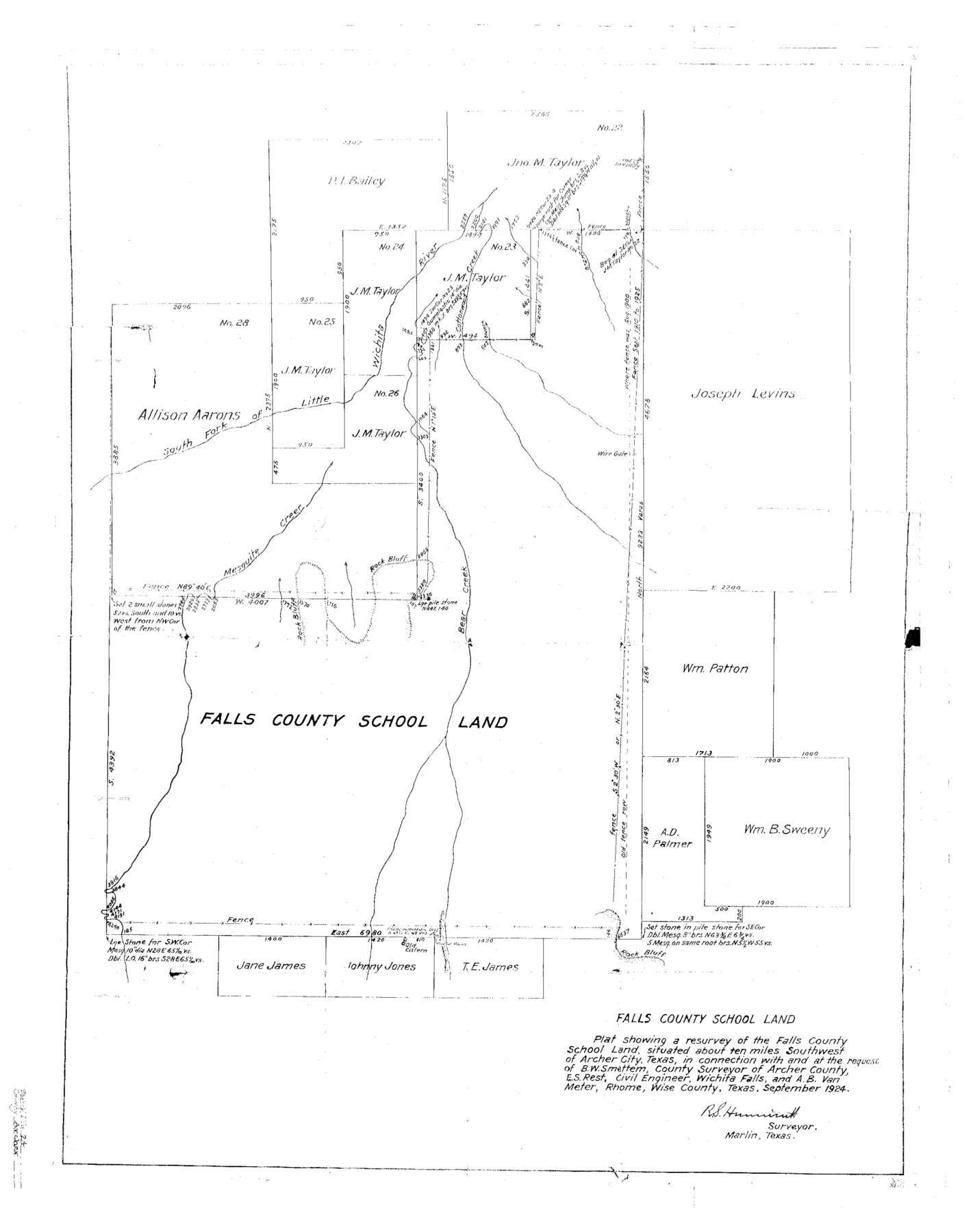
Plat showing a resurvey of the Falls County School Land
-
Map/Doc
10832
-
Collection
General Map Collection
-
Object Dates
1924 (Creation Date)
-
People and Organizations
R.S. Hunnicutt (Surveyor/Engineer)
-
Counties
Archer
-
Subjects
Surveying Sketch File
-
Height x Width
31.7 x 25.0 inches
80.5 x 63.5 cm
-
Medium
blueprint/diazo
-
Features
South fork of Little Wichita River
Mesquite Creek
Bear Creek
Rock Bluff
Part of: General Map Collection
Webb County Working Sketch 46

Print $20.00
- Digital $50.00
Webb County Working Sketch 46
1947
Size 18.4 x 23.5 inches
Map/Doc 72411
Terrell County Working Sketch 76

Print $20.00
- Digital $50.00
Terrell County Working Sketch 76
1982
Size 31.8 x 20.1 inches
Map/Doc 69597
Brazos County Sketch File 4

Print $4.00
- Digital $50.00
Brazos County Sketch File 4
1928
Size 11.5 x 7.3 inches
Map/Doc 15557
Hydrographic Survey H-6395 of Outer Coast of Padre Island; Gulf of Mexico

Print $40.00
- Digital $50.00
Hydrographic Survey H-6395 of Outer Coast of Padre Island; Gulf of Mexico
1938
Size 55.1 x 33.3 inches
Map/Doc 2697
Flight Mission No. DIX-6P, Frame 129, Aransas County

Print $20.00
- Digital $50.00
Flight Mission No. DIX-6P, Frame 129, Aransas County
1956
Size 18.9 x 22.4 inches
Map/Doc 83835
Kendall County Working Sketch 14

Print $20.00
- Digital $50.00
Kendall County Working Sketch 14
1967
Size 37.6 x 33.1 inches
Map/Doc 66686
Florida called by ye French Louisiana & c.

Print $20.00
- Digital $50.00
Florida called by ye French Louisiana & c.
1728
Size 9.6 x 14.3 inches
Map/Doc 94110
San Patricio County Sketch File 48

Print $88.00
- Digital $50.00
San Patricio County Sketch File 48
Size 9.0 x 9.0 inches
Map/Doc 36285
Calhoun County Sketch File 19

Print $70.00
- Digital $50.00
Calhoun County Sketch File 19
1998
Size 11.1 x 8.1 inches
Map/Doc 35992
[San Antonio & Aransas Pass]
![64209, [San Antonio & Aransas Pass], General Map Collection](https://historictexasmaps.com/wmedia_w700/maps/64209.tif.jpg)
Print $20.00
- Digital $50.00
[San Antonio & Aransas Pass]
Size 15.2 x 45.5 inches
Map/Doc 64209
[Surveys in the Jefferson District]
![3177, [Surveys in the Jefferson District], General Map Collection](https://historictexasmaps.com/wmedia_w700/maps/3177.tif.jpg)
Print $2.00
- Digital $50.00
[Surveys in the Jefferson District]
1841
Size 9.8 x 8.0 inches
Map/Doc 3177
Crockett County Rolled Sketch 99

Print $20.00
- Digital $50.00
Crockett County Rolled Sketch 99
Size 37.2 x 38.2 inches
Map/Doc 95401
You may also like
Flight Mission No. CRC-3R, Frame 12, Chambers County

Print $20.00
- Digital $50.00
Flight Mission No. CRC-3R, Frame 12, Chambers County
1956
Size 18.4 x 22.2 inches
Map/Doc 84786
La Salle County Sketch File 52

Print $9.00
- Digital $50.00
La Salle County Sketch File 52
1949
Size 11.7 x 9.1 inches
Map/Doc 29620
Grimes County Working Sketch 3

Print $20.00
- Digital $50.00
Grimes County Working Sketch 3
1946
Size 34.1 x 29.1 inches
Map/Doc 63294
[Sketch Between Collingsworth County and Oklahoma]
![89663, [Sketch Between Collingsworth County and Oklahoma], Twichell Survey Records](https://historictexasmaps.com/wmedia_w700/maps/89663-1.tif.jpg)
Print $40.00
- Digital $50.00
[Sketch Between Collingsworth County and Oklahoma]
Size 9.4 x 62.5 inches
Map/Doc 89663
Hale County Rolled Sketch 8

Print $20.00
- Digital $50.00
Hale County Rolled Sketch 8
1910
Size 38.0 x 25.9 inches
Map/Doc 6046

Atascosa County Sketch File 33

Print $40.00
- Digital $50.00
Atascosa County Sketch File 33
1916
Size 24.9 x 19.7 inches
Map/Doc 10865

Gaines County Working Sketch 17

Print $20.00
- Digital $50.00
Gaines County Working Sketch 17
1964
Size 47.6 x 34.5 inches
Map/Doc 69317
No. 3 Chart of Channel connecting Corpus Christi Bay with Aransas Bay, Texas

Print $20.00
- Digital $50.00
No. 3 Chart of Channel connecting Corpus Christi Bay with Aransas Bay, Texas
1878
Size 18.3 x 27.3 inches
Map/Doc 72781
Leon County Sketch File 2

Print $4.00
- Digital $50.00
Leon County Sketch File 2
1852
Size 8.1 x 5.1 inches
Map/Doc 29711
Burnet County Sketch File 36

Print $60.00
- Digital $50.00
Burnet County Sketch File 36
1935
Size 25.7 x 17.6 inches
Map/Doc 11025