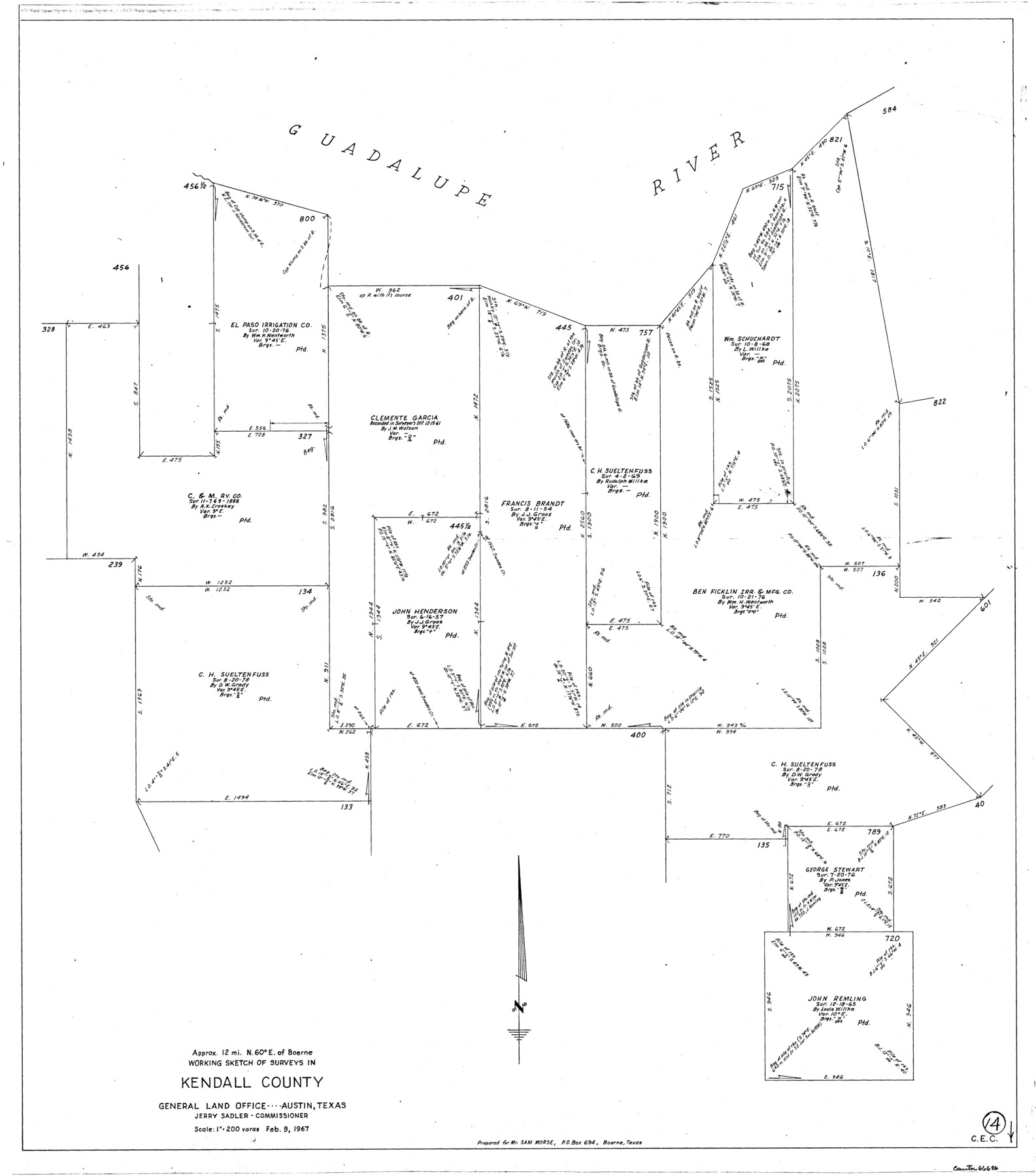
Kendall County Working Sketch 14
-
Map/Doc
66686
-
Collection
General Map Collection
-
Object Dates
2/9/1967 (Creation Date)
-
Counties
Kendall
-
Subjects
Surveying Working Sketch
-
Height x Width
37.6 x 33.1 inches
95.5 x 84.1 cm
-
Scale
1" = 200 varas
Part of: General Map Collection
Tom Green County Sketch File XXX

Print $20.00
- Digital $50.00
Tom Green County Sketch File XXX
Size 17.0 x 20.5 inches
Map/Doc 12457
Sketch F No. 2 Showing the progress of the Survey of Cedar Keys, Bahia Honda, Key Biscayne, Key West & Dry Tortugas In Section No. VI

Print $20.00
- Digital $50.00
Sketch F No. 2 Showing the progress of the Survey of Cedar Keys, Bahia Honda, Key Biscayne, Key West & Dry Tortugas In Section No. VI
1849
Size 10.8 x 18.3 inches
Map/Doc 97217
Montgomery County Rolled Sketch 26A

Print $20.00
- Digital $50.00
Montgomery County Rolled Sketch 26A
1941
Size 29.1 x 38.8 inches
Map/Doc 6809
Live Oak County Working Sketch 36

Print $20.00
- Digital $50.00
Live Oak County Working Sketch 36
2008
Size 33.5 x 35.8 inches
Map/Doc 88879
Dimmit County Boundary File 10a

Print $4.00
- Digital $50.00
Dimmit County Boundary File 10a
Size 14.0 x 8.5 inches
Map/Doc 52611
Survey and Location of the Corpus Christi & Rio Grande Railway Under Charter of May 24th 1873

Print $40.00
- Digital $50.00
Survey and Location of the Corpus Christi & Rio Grande Railway Under Charter of May 24th 1873
1874
Size 12.5 x 58.7 inches
Map/Doc 64092
Crockett County Sketch File 54

Print $10.00
- Digital $50.00
Crockett County Sketch File 54
1915
Size 11.3 x 8.9 inches
Map/Doc 19824

Karnes County Sketch File 6

Print $4.00
- Digital $50.00
Karnes County Sketch File 6
1858
Size 7.7 x 8.1 inches
Map/Doc 28557
Menard County Sketch File 29

Print $20.00
- Digital $50.00
Menard County Sketch File 29
1962
Size 21.0 x 41.1 inches
Map/Doc 10543
Pecos County Rolled Sketch 75

Print $20.00
- Digital $50.00
Pecos County Rolled Sketch 75
Size 18.8 x 37.5 inches
Map/Doc 7237
Flight Mission No. BQR-13K, Frame 21, Brazoria County

Print $20.00
- Digital $50.00
Flight Mission No. BQR-13K, Frame 21, Brazoria County
1952
Size 18.8 x 22.4 inches
Map/Doc 84069
You may also like
Harrison County Sketch File 8

Print $20.00
- Digital $50.00
Harrison County Sketch File 8
1861
Size 17.3 x 15.9 inches
Map/Doc 11685
Flight Mission No. BRA-7M, Frame 21, Jefferson County

Print $20.00
- Digital $50.00
Flight Mission No. BRA-7M, Frame 21, Jefferson County
1953
Size 18.4 x 22.2 inches
Map/Doc 85472
Chambers County Sketch File 49

Print $26.00
- Digital $50.00
Chambers County Sketch File 49
Size 14.3 x 8.9 inches
Map/Doc 18045
Runnels County Working Sketch 5

Print $20.00
- Digital $50.00
Runnels County Working Sketch 5
1907
Size 17.2 x 16.1 inches
Map/Doc 63601
Gulf of Mexico

Print $20.00
- Digital $50.00
Gulf of Mexico
1900
Size 18.4 x 28.1 inches
Map/Doc 72649
A Map of the West-Indies & c., Mexico or New Spain. Also ye trade winds and ye several tracts made by ye Galeons and Flota from place to place

Print $20.00
- Digital $50.00
A Map of the West-Indies & c., Mexico or New Spain. Also ye trade winds and ye several tracts made by ye Galeons and Flota from place to place
1729
Size 9.5 x 13.6 inches
Map/Doc 94087
Garza County Rolled Sketch 6

Print $53.00
- Digital $50.00
Garza County Rolled Sketch 6
Size 43.6 x 30.0 inches
Map/Doc 9052
Concho County Sketch File 17

Print $20.00
- Digital $50.00
Concho County Sketch File 17
1896
Size 10.2 x 20.9 inches
Map/Doc 11152
Ellis County Sketch File 1

Print $6.00
- Digital $50.00
Ellis County Sketch File 1
1849
Size 6.5 x 7.9 inches
Map/Doc 21824
Briscoe County Sketch File A-1

Print $16.00
- Digital $50.00
Briscoe County Sketch File A-1
1894
Size 10.7 x 8.4 inches
Map/Doc 16399
Flight Mission No. DCL-4C, Frame 4, Kenedy County

Print $20.00
- Digital $50.00
Flight Mission No. DCL-4C, Frame 4, Kenedy County
1943
Size 18.7 x 22.3 inches
Map/Doc 85805
Map of Ohio, Michigan, Indiana and Kentucky

Print $20.00
- Digital $50.00
Map of Ohio, Michigan, Indiana and Kentucky
1885
Size 12.2 x 9.0 inches
Map/Doc 93520