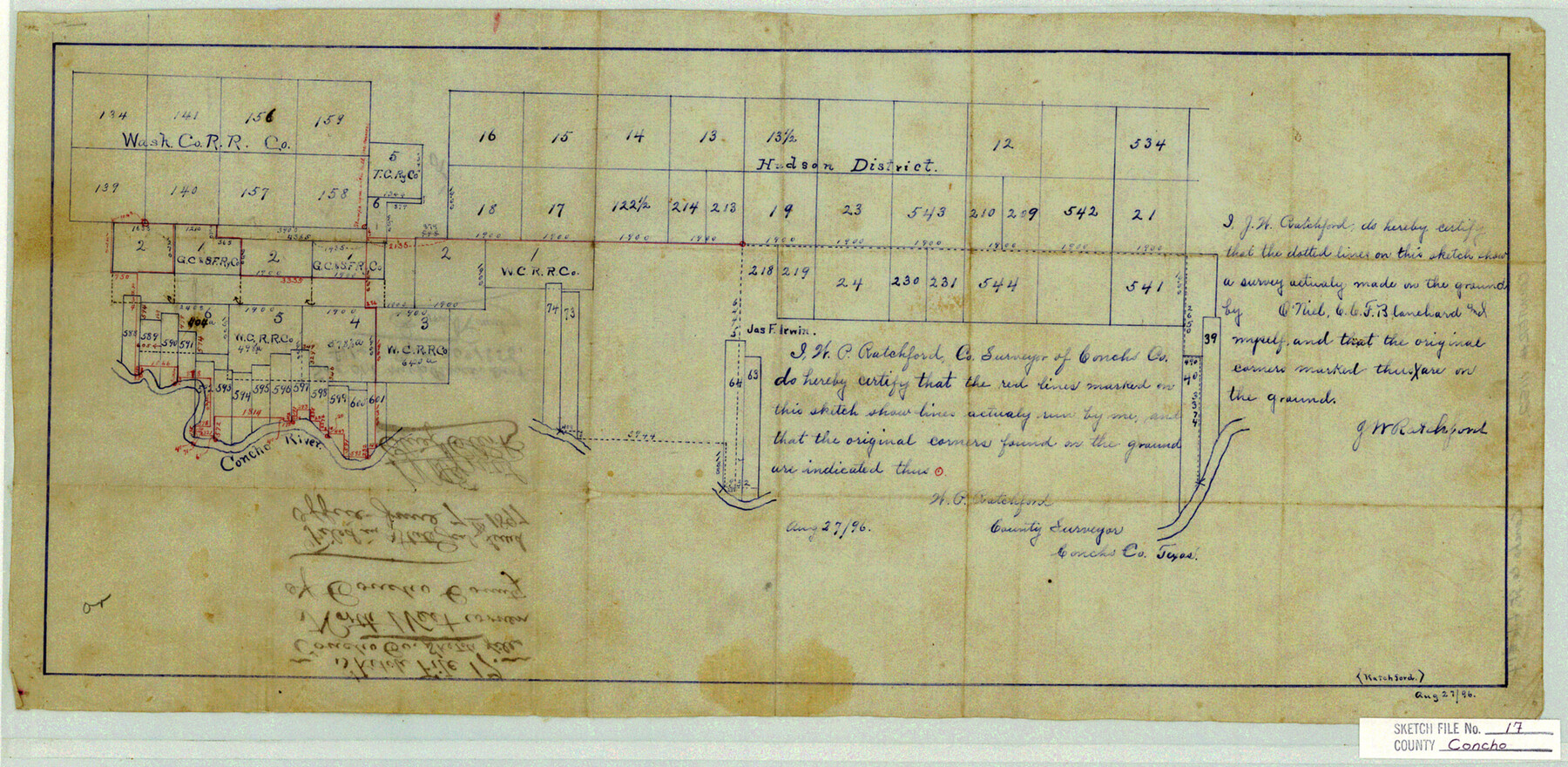
Concho County Sketch File 17
North West corner of Concho County
-
Map/Doc
11152
-
Collection
General Map Collection
-
Object Dates
1896/8/27 (Creation Date)
1897/6/7 (File Date)
-
People and Organizations
G.W. Ratchford (Surveyor/Engineer)
O'Niel (Surveyor/Engineer)
C.C.F. Blanchard (Surveyor/Engineer)
-
Counties
Concho Runnels Tom Green
-
Subjects
Surveying Sketch File
-
Height x Width
10.2 x 20.9 inches
25.9 x 53.1 cm
-
Medium
paper, manuscript
-
Features
Concho River
Part of: General Map Collection
Johnson County Working Sketch 10

Print $20.00
- Digital $50.00
Johnson County Working Sketch 10
1953
Size 26.2 x 37.1 inches
Map/Doc 66623
Flight Mission No. CUG-3P, Frame 190, Kleberg County

Print $20.00
- Digital $50.00
Flight Mission No. CUG-3P, Frame 190, Kleberg County
1956
Size 18.6 x 22.4 inches
Map/Doc 86294
Wheeler County Working Sketch 7

Print $40.00
- Digital $50.00
Wheeler County Working Sketch 7
1972
Size 50.1 x 42.9 inches
Map/Doc 72496
Burnet County Working Sketch 15

Print $20.00
- Digital $50.00
Burnet County Working Sketch 15
1979
Size 38.2 x 30.4 inches
Map/Doc 67858
Aransas County Rolled Sketch 19

Print $20.00
- Digital $50.00
Aransas County Rolled Sketch 19
1979
Size 24.8 x 36.7 inches
Map/Doc 82559
Chambers County Sketch File 44

Print $36.00
- Digital $50.00
Chambers County Sketch File 44
Size 13.9 x 8.7 inches
Map/Doc 17735
La Salle County Working Sketch 43

Print $20.00
- Digital $50.00
La Salle County Working Sketch 43
1976
Size 32.7 x 40.1 inches
Map/Doc 70344
Refugio County NRC Article 33.136 Location Key Sheet

Print $20.00
- Digital $50.00
Refugio County NRC Article 33.136 Location Key Sheet
1979
Size 27.0 x 23.0 inches
Map/Doc 77034
Kinney County Working Sketch 41

Print $20.00
- Digital $50.00
Kinney County Working Sketch 41
1973
Size 36.2 x 44.2 inches
Map/Doc 70223
Newton County Rolled Sketch 28

Print $373.00
- Digital $50.00
Newton County Rolled Sketch 28
1938
Size 10.3 x 15.4 inches
Map/Doc 47418
Duval County Sketch File 60

Print $6.00
- Digital $50.00
Duval County Sketch File 60
1940
Size 11.3 x 9.0 inches
Map/Doc 21428
Hays County Rolled Sketch 26

Print $20.00
- Digital $50.00
Hays County Rolled Sketch 26
1943
Size 27.7 x 25.6 inches
Map/Doc 6182
You may also like
Victoria, Texas: The City of Roses

Victoria, Texas: The City of Roses
1910
Size 3.6 x 4.8 inches
Map/Doc 97056
[Redfish Bay, Aransas Pass, and part of Mustang Island]
![83009, [Redfish Bay, Aransas Pass, and part of Mustang Island], General Map Collection](https://historictexasmaps.com/wmedia_w700/maps/83009.tif.jpg)
Print $40.00
- Digital $50.00
[Redfish Bay, Aransas Pass, and part of Mustang Island]
1930
Size 51.0 x 46.5 inches
Map/Doc 83009
Galveston County NRC Article 33.136 Sketch 49

Print $24.00
- Digital $50.00
Galveston County NRC Article 33.136 Sketch 49
2007
Size 24.0 x 36.0 inches
Map/Doc 94663

[Capitol Leagues in Oldham County]
![4506, [Capitol Leagues in Oldham County], General Map Collection](https://historictexasmaps.com/wmedia_w700/maps/4506-1.tif.jpg)
Print $20.00
- Digital $50.00
[Capitol Leagues in Oldham County]
1918
Size 37.9 x 30.4 inches
Map/Doc 4506
Township 2 North Range 12 West, North Western District, Louisiana

Print $20.00
- Digital $50.00
Township 2 North Range 12 West, North Western District, Louisiana
1884
Size 19.6 x 24.7 inches
Map/Doc 65875
Mexico Comision Pesquisidora de la Frontera del Norte

Mexico Comision Pesquisidora de la Frontera del Norte
1874
Map/Doc 97125
Terrell County Working Sketch 36

Print $20.00
- Digital $50.00
Terrell County Working Sketch 36
1948
Size 26.8 x 39.9 inches
Map/Doc 62129
Wilbarger County Sketch File 18

Print $12.00
- Digital $50.00
Wilbarger County Sketch File 18
1886
Size 14.3 x 8.8 inches
Map/Doc 40209
Henderson County

Print $40.00
- Digital $50.00
Henderson County
1922
Size 33.3 x 62.4 inches
Map/Doc 1854

Val Verde County Sketch File 35

Print $23.00
- Digital $50.00
Val Verde County Sketch File 35
1937
Size 15.3 x 9.4 inches
Map/Doc 12574