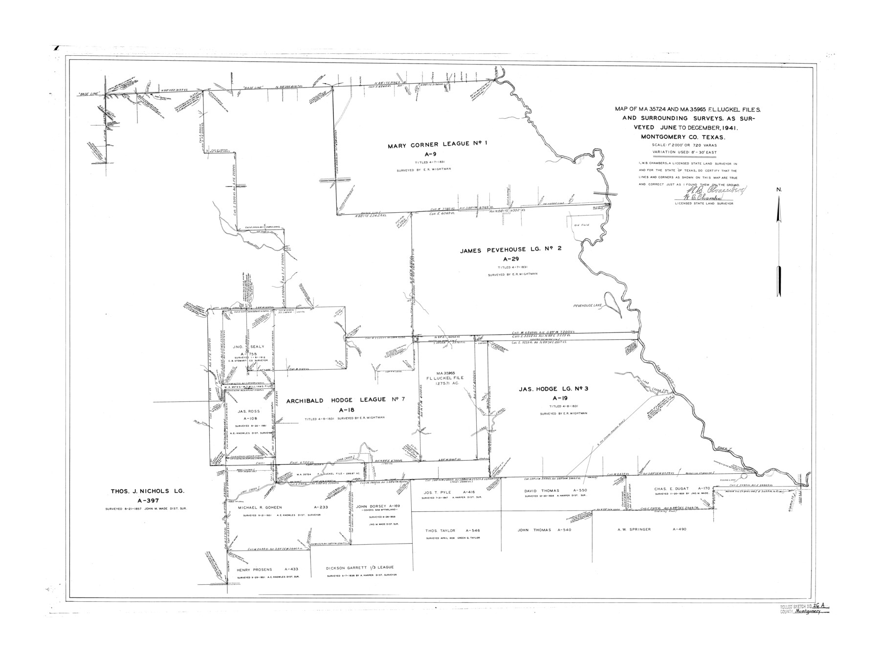
Montgomery County Rolled Sketch 26A
Map of MA-35724 and MA-35965 F.L. Luckel files and surrounding surveys
-
Map/Doc
6809
-
Collection
General Map Collection
-
Object Dates
1941 (Creation Date)
1942/1/29 (File Date)
-
People and Organizations
W.B. Chambers (Surveyor/Engineer)
-
Counties
Montgomery
-
Subjects
Surveying Rolled Sketch
-
Height x Width
29.1 x 38.8 inches
73.9 x 98.6 cm
-
Scale
1" = 720 varas
Part of: General Map Collection
Controlled Mosaic by Jack Amman Photogrammetric Engineers, Inc - Sheet 20

Print $20.00
- Digital $50.00
Controlled Mosaic by Jack Amman Photogrammetric Engineers, Inc - Sheet 20
1954
Size 20.0 x 24.0 inches
Map/Doc 83467
Armstrong County Sketch File 2

Print $40.00
- Digital $50.00
Armstrong County Sketch File 2
Size 21.5 x 40.0 inches
Map/Doc 10371
Orange County Sketch File 25

Print $20.00
- Digital $50.00
Orange County Sketch File 25
1914
Size 19.6 x 38.2 inches
Map/Doc 12122

Schleicher County Sketch File 13

Print $10.00
- Digital $50.00
Schleicher County Sketch File 13
1916
Size 14.4 x 8.9 inches
Map/Doc 36493
Terrell County Rolled Sketch 56

Print $20.00
- Digital $50.00
Terrell County Rolled Sketch 56
1986
Size 36.6 x 42.0 inches
Map/Doc 9992
Marion County Working Sketch 37

Print $20.00
- Digital $50.00
Marion County Working Sketch 37
1986
Size 30.0 x 43.0 inches
Map/Doc 70813
San Patricio County NRC Article 33.136 Sketch 1

Print $32.00
- Digital $50.00
San Patricio County NRC Article 33.136 Sketch 1
2001
Size 18.5 x 24.1 inches
Map/Doc 61623
Map of Nacogdoches County

Print $20.00
- Digital $50.00
Map of Nacogdoches County
1881
Size 24.1 x 21.5 inches
Map/Doc 4605
Houston including Bellaire, Bunker Hill, Galena Park, Hedwig, Hilshire, Hunters Creek, Jacinto City, Jersey Village, Missouri City, Pasadena, Piney Point, South Houston, Spring Valley, West University Place and adjoining communities [Recto]
![94179, Houston including Bellaire, Bunker Hill, Galena Park, Hedwig, Hilshire, Hunters Creek, Jacinto City, Jersey Village, Missouri City, Pasadena, Piney Point, South Houston, Spring Valley, West University Place and adjoining communities [Recto], General Map Collection](https://historictexasmaps.com/wmedia_w700/maps/94179.tif.jpg)
Houston including Bellaire, Bunker Hill, Galena Park, Hedwig, Hilshire, Hunters Creek, Jacinto City, Jersey Village, Missouri City, Pasadena, Piney Point, South Houston, Spring Valley, West University Place and adjoining communities [Recto]
Size 27.1 x 42.6 inches
Map/Doc 94179
Copy of Surveyor's Field Book, Morris Browning - In Blocks 7, 5 & 4, I&GNRRCo., Hutchinson and Carson Counties, Texas

Print $2.00
- Digital $50.00
Copy of Surveyor's Field Book, Morris Browning - In Blocks 7, 5 & 4, I&GNRRCo., Hutchinson and Carson Counties, Texas
1888
Size 7.0 x 8.8 inches
Map/Doc 62276
Flight Mission No. DAG-24K, Frame 154, Matagorda County

Print $20.00
- Digital $50.00
Flight Mission No. DAG-24K, Frame 154, Matagorda County
1953
Size 18.5 x 22.2 inches
Map/Doc 86568
You may also like
Ellis County Sketch File 5

Print $4.00
- Digital $50.00
Ellis County Sketch File 5
Size 10.3 x 8.2 inches
Map/Doc 21834
Map of Smith County

Print $20.00
- Digital $50.00
Map of Smith County
1855
Size 21.9 x 21.3 inches
Map/Doc 4038
Right of Way and Track Map, International & Gt. Northern Ry. Operated by the International & Gt. Northern Ry. Co. Gulf Division, Mineola Branch

Print $40.00
- Digital $50.00
Right of Way and Track Map, International & Gt. Northern Ry. Operated by the International & Gt. Northern Ry. Co. Gulf Division, Mineola Branch
1917
Size 25.5 x 116.7 inches
Map/Doc 64701
Sabine and Neches Rivers

Print $20.00
- Digital $50.00
Sabine and Neches Rivers
Size 19.6 x 43.7 inches
Map/Doc 94444
Flight Mission No. CGN-3P, Frame 24, San Patricio County

Print $20.00
- Digital $50.00
Flight Mission No. CGN-3P, Frame 24, San Patricio County
1956
Size 18.5 x 22.3 inches
Map/Doc 86982
Map showing the environs of Brazos Island, Texas

Print $20.00
- Digital $50.00
Map showing the environs of Brazos Island, Texas
Size 18.1 x 25.0 inches
Map/Doc 72926
Trinity River, Hughes Crossing Sheet/Chambers Creek

Print $6.00
- Digital $50.00
Trinity River, Hughes Crossing Sheet/Chambers Creek
1931
Size 32.5 x 30.2 inches
Map/Doc 65239
Goliad County Sketch File 27

Print $20.00
- Digital $50.00
Goliad County Sketch File 27
Size 19.0 x 24.4 inches
Map/Doc 11568
Dimmit County Rolled Sketch 10

Print $20.00
- Digital $50.00
Dimmit County Rolled Sketch 10
1941
Size 29.2 x 32.1 inches
Map/Doc 5719
Shelby County Rolled Sketch 17

Print $20.00
- Digital $50.00
Shelby County Rolled Sketch 17
1975
Size 34.6 x 26.4 inches
Map/Doc 7783
Chambers County Boundary File 3

Print $112.00
- Digital $50.00
Chambers County Boundary File 3
Size 52.5 x 3.9 inches
Map/Doc 51249
Throckmorton County Working Sketch 4

Print $20.00
- Digital $50.00
Throckmorton County Working Sketch 4
1949
Size 25.0 x 24.9 inches
Map/Doc 62113