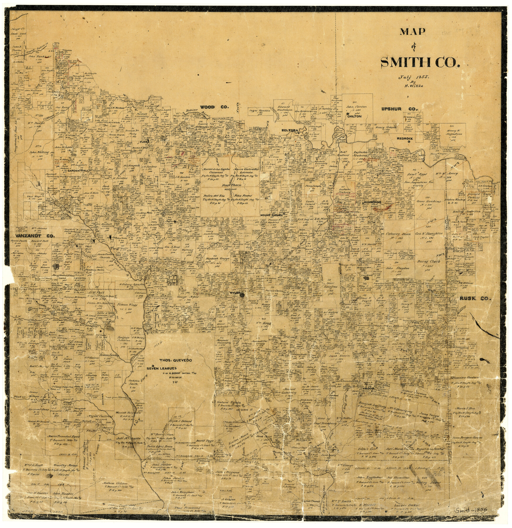
Map of Smith County
-
Map/Doc
4038
-
Collection
General Map Collection
-
Object Dates
1855 (Creation Date)
-
People and Organizations
Texas General Land Office (Publisher)
H. Wilke (Compiler)
H. Willke (Draftsman)
-
Counties
Smith
-
Subjects
County
-
Height x Width
21.9 x 21.3 inches
55.6 x 54.1 cm
-
Features
Flat Creek
Caney Creek
East Fork of Harris Creek
Neches River
Murchison Creek
Kickapoo Creek
Battle Creek
Indian Creek
Tyler
Wiley Creek
Rabbit Creek
Mount Carmel
Mulberry Creek
Saline Creek
West Fork of Mud Creek
Mud Creek
East Fork of Mud Creek
Troop
Black Fork [of Neches River]
Seven Leagues
Quapaw Creek
Garden Valley
Dry Creek
Chilton
Belzora
Rogers Creek
Little Sandy [Creek]
Sabine River
Flora
Rock Creek
Village Creek
Grand Saline Creek
Duck Creek
Prairie Creek
Mill Creek
Redrock
Gumspring
Harris Creek
Little Saline Creek
Horsleg's Creek
West Fork of Harris Creek
Part of: General Map Collection
Terrell County Working Sketch 43

Print $20.00
- Digital $50.00
Terrell County Working Sketch 43
1957
Size 45.0 x 38.4 inches
Map/Doc 62136
Brewster County Rolled Sketch 29

Print $20.00
- Digital $50.00
Brewster County Rolled Sketch 29
1910
Size 17.5 x 18.5 inches
Map/Doc 5216
Cameron County Sketch File 7a

Print $32.00
- Digital $50.00
Cameron County Sketch File 7a
1982
Size 11.2 x 8.4 inches
Map/Doc 17115
Trinity River, Levee Improvement Districts, Widths of Floodways

Print $20.00
- Digital $50.00
Trinity River, Levee Improvement Districts, Widths of Floodways
1920
Size 31.8 x 23.2 inches
Map/Doc 65254
Wise County Sketch File 42

Print $4.00
- Digital $50.00
Wise County Sketch File 42
1876
Size 8.0 x 6.5 inches
Map/Doc 40601
Map of Jasper County

Print $20.00
- Digital $50.00
Map of Jasper County
1839
Size 40.2 x 28.8 inches
Map/Doc 78407
Val Verde County Working Sketch 120

Print $40.00
- Digital $50.00
Val Verde County Working Sketch 120
2005
Size 30.7 x 50.0 inches
Map/Doc 83589

Coast Chart No. 207 - Matagorda Bay, Texas

Print $20.00
- Digital $50.00
Coast Chart No. 207 - Matagorda Bay, Texas
1888
Size 34.2 x 40.7 inches
Map/Doc 70000
Shelby County Sketch File 32

Print $20.00
- Digital $50.00
Shelby County Sketch File 32
1949
Size 23.4 x 17.7 inches
Map/Doc 12321
Matagorda County Rolled Sketch 34

Print $20.00
- Digital $50.00
Matagorda County Rolled Sketch 34
Size 25.4 x 40.5 inches
Map/Doc 6695
Randall County

Print $20.00
- Digital $50.00
Randall County
1958
Size 43.0 x 35.1 inches
Map/Doc 73269
You may also like
Travis County Appraisal District Plat Map 2_0601

Print $20.00
- Digital $50.00
Travis County Appraisal District Plat Map 2_0601
Size 21.5 x 26.4 inches
Map/Doc 94235
Terry County Sketch File 8

Print $20.00
- Digital $50.00
Terry County Sketch File 8
1932
Size 23.2 x 42.5 inches
Map/Doc 10393
Gaines County Working Sketch 35

Print $20.00
- Digital $50.00
Gaines County Working Sketch 35
1991
Size 36.4 x 42.8 inches
Map/Doc 69335
Working Sketch Hale County

Print $20.00
- Digital $50.00
Working Sketch Hale County
1909
Size 17.9 x 20.9 inches
Map/Doc 90745
Current Miscellaneous File 44

Print $10.00
- Digital $50.00
Current Miscellaneous File 44
1954
Size 11.3 x 8.8 inches
Map/Doc 73985
Cameron County Rolled Sketch US2

Print $168.00
- Digital $50.00
Cameron County Rolled Sketch US2
1913
Size 10.4 x 16.3 inches
Map/Doc 43804
Outer Continental Shelf Leasing Maps (Texas Offshore Operations)

Print $20.00
- Digital $50.00
Outer Continental Shelf Leasing Maps (Texas Offshore Operations)
1954
Size 14.7 x 14.2 inches
Map/Doc 75834
Castro County Sketch File 13

Print $4.00
- Digital $50.00
Castro County Sketch File 13
1962
Size 14.1 x 8.6 inches
Map/Doc 17509
Burleson County Working Sketch 4

Print $20.00
- Digital $50.00
Burleson County Working Sketch 4
1979
Size 33.3 x 35.6 inches
Map/Doc 67723
A Trip to Winter Garden District, Carrizo Springs, Texas in the Shallow Water Area of the Famous Artesian Belt

Print $20.00
- Digital $50.00
A Trip to Winter Garden District, Carrizo Springs, Texas in the Shallow Water Area of the Famous Artesian Belt
1920
Size 8.9 x 15.5 inches
Map/Doc 96766
[Note to Thos. W. Ward to make corrections for J. D. Wheeler, Survey 147 in San Patricio County, San Patricio District]
![69748, [Note to Thos. W. Ward to make corrections for J. D. Wheeler, Survey 147 in San Patricio County, San Patricio District], General Map Collection](https://historictexasmaps.com/wmedia_w700/maps/69748.tif.jpg)
Print $2.00
- Digital $50.00
[Note to Thos. W. Ward to make corrections for J. D. Wheeler, Survey 147 in San Patricio County, San Patricio District]
1842
Size 4.5 x 6.8 inches
Map/Doc 69748
Pecos County Sketch File 91

Print $20.00
- Digital $50.00
Pecos County Sketch File 91
1951
Size 20.9 x 14.0 inches
Map/Doc 12184