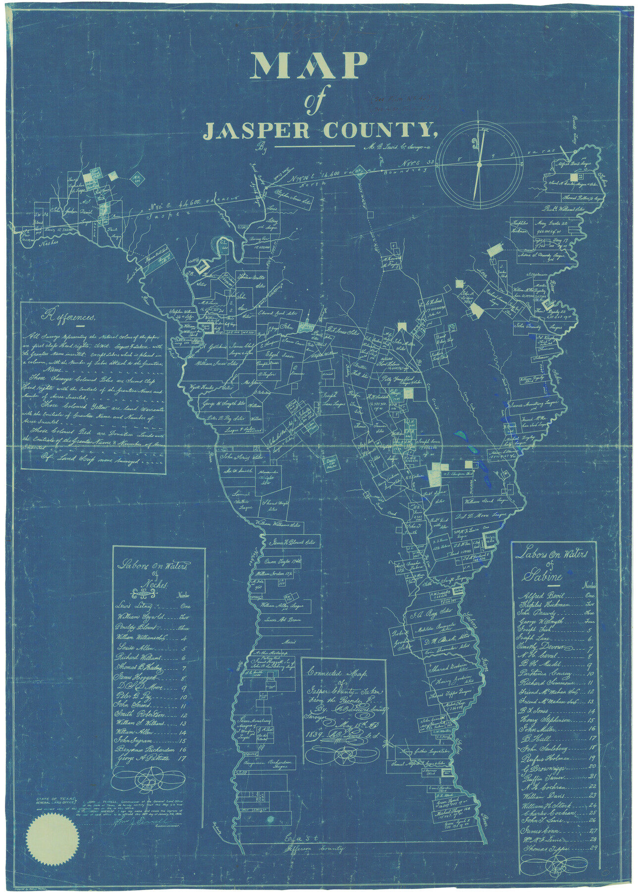
Map of Jasper County
-
Map/Doc
78407
-
Collection
General Map Collection
-
Object Dates
1839 (Creation Date)
1906 (Copy/Tracing Date)
-
People and Organizations
M.B. Lewis (Surveyor/Engineer)
Addison Walker (Copier)
-
Counties
Jasper
-
Subjects
County
-
Height x Width
40.2 x 28.8 inches
102.1 x 73.2 cm
-
Features
N[ew] Columbia
Big Sandy Creek
Lewis Ferry
Teran
Devils Creek
Princeton
Cypress Creek
Salem
Belgrade
Trout Creek
Oak Creek
Davis Creek
Quick Sand Creek
Caney Creek
Big Cow Creek
Thickety Creek
Bevils Ferry
Burlport
Zavala
Indian Creek
Jasper
Sandy Creek
Little Cow Creek
Hickman's Creek
Neches River
Angelina River
Ayish Bayou
Jones' Bridge
Bear Creek
Sabine River
Bulk Creek
Part of: General Map Collection
Tom Green County Sketch File 71

Print $20.00
- Digital $50.00
Tom Green County Sketch File 71
1948
Size 17.5 x 20.6 inches
Map/Doc 12447
Kinney County Working Sketch 25

Print $20.00
- Digital $50.00
Kinney County Working Sketch 25
1952
Size 30.9 x 32.9 inches
Map/Doc 70207
Presidio County Working Sketch 93

Print $20.00
- Digital $50.00
Presidio County Working Sketch 93
1976
Size 27.7 x 27.3 inches
Map/Doc 71770
Flight Mission No. CUG-2P, Frame 59, Kleberg County

Print $20.00
- Digital $50.00
Flight Mission No. CUG-2P, Frame 59, Kleberg County
1956
Size 18.4 x 22.1 inches
Map/Doc 86196
Morris County Rolled Sketch 2A

Print $20.00
- Digital $50.00
Morris County Rolled Sketch 2A
Size 36.0 x 25.0 inches
Map/Doc 10236
Kimble County Rolled Sketch 20

Print $20.00
- Digital $50.00
Kimble County Rolled Sketch 20
Size 14.6 x 18.1 inches
Map/Doc 6511
Culberson Co.

Print $40.00
- Digital $50.00
Culberson Co.
1908
Size 49.0 x 32.9 inches
Map/Doc 66796
Stephens County Sketch File 1

Print $20.00
- Digital $50.00
Stephens County Sketch File 1
1857
Size 19.2 x 16.1 inches
Map/Doc 12347
Flight Mission No. DAG-26K, Frame 60, Matagorda County

Print $20.00
- Digital $50.00
Flight Mission No. DAG-26K, Frame 60, Matagorda County
1953
Size 18.7 x 22.7 inches
Map/Doc 86580
Flight Mission No. BRA-16M, Frame 112, Jefferson County

Print $20.00
- Digital $50.00
Flight Mission No. BRA-16M, Frame 112, Jefferson County
1953
Size 18.6 x 22.2 inches
Map/Doc 85722
Pecos County Sketch File U

Print $20.00
- Digital $50.00
Pecos County Sketch File U
1902
Size 20.9 x 32.7 inches
Map/Doc 12188
San Patricio County NRC Article 33.136 Location Key Sheet

Print $20.00
- Digital $50.00
San Patricio County NRC Article 33.136 Location Key Sheet
1975
Size 27.0 x 23.0 inches
Map/Doc 77037
You may also like

Laguna Madre, Texas from Latitude 26° 20' to 26° 27'

Print $40.00
- Digital $50.00
Laguna Madre, Texas from Latitude 26° 20' to 26° 27'
1879
Size 32.7 x 55.0 inches
Map/Doc 73498
Upton County Sketch File 18

Print $20.00
- Digital $50.00
Upton County Sketch File 18
1927
Size 18.9 x 29.4 inches
Map/Doc 12514
Hansford County Sketch File 8

Print $6.00
- Digital $50.00
Hansford County Sketch File 8
1927
Size 11.3 x 8.7 inches
Map/Doc 24960
Aransas County Rolled Sketch 19B

Print $20.00
- Digital $50.00
Aransas County Rolled Sketch 19B
1979
Size 25.7 x 18.7 inches
Map/Doc 76077
Titus County Sketch File 14

Print $4.00
- Digital $50.00
Titus County Sketch File 14
Size 9.7 x 8.3 inches
Map/Doc 38157
Ector County Working Sketch 34
Print $20.00
- Digital $50.00
Ector County Working Sketch 34
2025
Size 22.6 x 33.6 inches
Map/Doc 97515
Palo Pinto County Sketch File 27

Print $21.00
- Digital $50.00
Palo Pinto County Sketch File 27
1875
Size 9.8 x 15.7 inches
Map/Doc 33430
Sketch Showing Block 142, Original Town, Survey 1, Block O

Print $20.00
- Digital $50.00
Sketch Showing Block 142, Original Town, Survey 1, Block O
Size 23.0 x 18.0 inches
Map/Doc 92782
[Cotton Belt] St. Louis Southwestern Railway of Texas, Alignment through Smith County
![64373, [Cotton Belt] St. Louis Southwestern Railway of Texas, Alignment through Smith County, General Map Collection](https://historictexasmaps.com/wmedia_w700/maps/64373.tif.jpg)
Print $20.00
- Digital $50.00
[Cotton Belt] St. Louis Southwestern Railway of Texas, Alignment through Smith County
1903
Size 21.4 x 28.4 inches
Map/Doc 64373
Right of Way Map, Belton Branch of the M.K.&T. RR.

Print $20.00
- Digital $50.00
Right of Way Map, Belton Branch of the M.K.&T. RR.
1896
Size 14.5 x 42.1 inches
Map/Doc 64219
Sketch of Resurvey, Township 5 North. Block 36. Texas and Pacific Railroad Company, Dawson County

Print $20.00
- Digital $50.00
Sketch of Resurvey, Township 5 North. Block 36. Texas and Pacific Railroad Company, Dawson County
1926
Size 24.6 x 25.0 inches
Map/Doc 92572