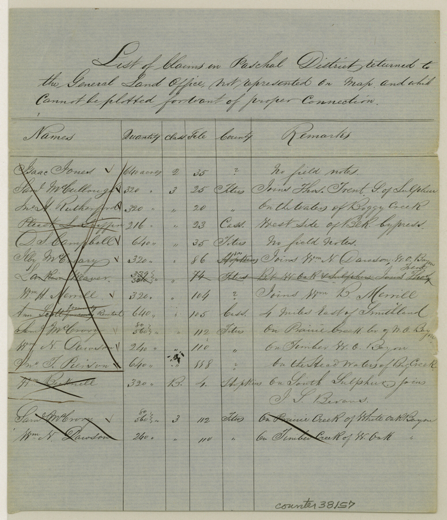
Titus County Sketch File 14
[List of claims not represented on GLO map]
-
Map/Doc
38157
-
Collection
General Map Collection
-
Object Dates
12/11/1984 (File Date)
-
Counties
Titus
-
Subjects
Surveying Sketch File
-
Height x Width
9.7 x 8.3 inches
24.6 x 21.1 cm
-
Medium
paper, manuscript
-
Features
Boggy Creek
Big Creek
Sulphur Creek
Part of: General Map Collection
Duval County Rolled Sketch 47

Print $40.00
- Digital $50.00
Duval County Rolled Sketch 47
1991
Size 35.4 x 48.0 inches
Map/Doc 8824
Maps of Gulf Intracoastal Waterway, Texas - Sabine River to the Rio Grande and connecting waterways including ship channels

Print $20.00
- Digital $50.00
Maps of Gulf Intracoastal Waterway, Texas - Sabine River to the Rio Grande and connecting waterways including ship channels
1966
Size 14.5 x 22.4 inches
Map/Doc 61918
Culberson County Rolled Sketch 30

Print $84.00
- Digital $50.00
Culberson County Rolled Sketch 30
1928
Size 57.1 x 36.1 inches
Map/Doc 8746
Val Verde County Rolled Sketch 78

Print $20.00
- Digital $50.00
Val Verde County Rolled Sketch 78
1981
Size 42.9 x 29.6 inches
Map/Doc 8140
Clay County Boundary File 11

Print $12.00
- Digital $50.00
Clay County Boundary File 11
Size 14.0 x 8.4 inches
Map/Doc 51400
Tom Green County Sketch File 80

Print $20.00
- Digital $50.00
Tom Green County Sketch File 80
1962
Size 20.6 x 35.6 inches
Map/Doc 12452
Intracoastal Waterway - Gibbstown to Port Arthur

Print $20.00
- Digital $50.00
Intracoastal Waterway - Gibbstown to Port Arthur
1957
Size 27.1 x 38.8 inches
Map/Doc 69829
Ochiltree County

Print $20.00
- Digital $50.00
Ochiltree County
1908
Size 42.5 x 40.6 inches
Map/Doc 66959
Schleicher County Sketch File 23a

Print $4.00
- Digital $50.00
Schleicher County Sketch File 23a
1937
Size 11.3 x 8.8 inches
Map/Doc 36514
South Part of Brewster Co.

Print $40.00
- Digital $50.00
South Part of Brewster Co.
1955
Size 48.9 x 41.4 inches
Map/Doc 95438
Val Verde County Working Sketch 43

Print $20.00
- Digital $50.00
Val Verde County Working Sketch 43
1945
Size 39.3 x 37.2 inches
Map/Doc 72178

You may also like
[Surveys along the Polk and Tyler County border]
![333, [Surveys along the Polk and Tyler County border], General Map Collection](https://historictexasmaps.com/wmedia_w700/maps/333.tif.jpg)
Print $2.00
- Digital $50.00
[Surveys along the Polk and Tyler County border]
Size 9.3 x 6.0 inches
Map/Doc 333
Nueces County Rolled Sketch 43A

Print $20.00
- Digital $50.00
Nueces County Rolled Sketch 43A
Size 24.0 x 35.4 inches
Map/Doc 6884
Webb County Sketch File 6-2

Print $20.00
- Digital $50.00
Webb County Sketch File 6-2
1927
Size 29.4 x 21.3 inches
Map/Doc 12616
Official Railroad and County Map of Texas

Print $40.00
Official Railroad and County Map of Texas
1914
Size 45.8 x 48.6 inches
Map/Doc 76233
International Railroad Map & Profile of the Second Fifty Miles East of Brazos River

Print $40.00
- Digital $50.00
International Railroad Map & Profile of the Second Fifty Miles East of Brazos River
1877
Size 19.0 x 52.0 inches
Map/Doc 64466
Flight Mission No. DCL-7C, Frame 121, Kenedy County

Print $20.00
- Digital $50.00
Flight Mission No. DCL-7C, Frame 121, Kenedy County
1943
Size 18.5 x 22.3 inches
Map/Doc 86086
Flight Mission No. BRA-17M, Frame 10, Jefferson County

Print $20.00
- Digital $50.00
Flight Mission No. BRA-17M, Frame 10, Jefferson County
1953
Size 18.5 x 22.2 inches
Map/Doc 85791
Tarrant County Sketch File 2

Print $4.00
- Digital $50.00
Tarrant County Sketch File 2
1857
Size 7.0 x 6.5 inches
Map/Doc 37674
Plan of the C. C. S. D. & R. G. N. G. R.R.

Print $20.00
- Digital $50.00
Plan of the C. C. S. D. & R. G. N. G. R.R.
1878
Size 14.3 x 40.9 inches
Map/Doc 64481
Dickens County

Print $20.00
- Digital $50.00
Dickens County
1915
Size 42.2 x 39.0 inches
Map/Doc 66805
General Highway Map, Milam County, Texas

Print $20.00
General Highway Map, Milam County, Texas
1940
Size 18.5 x 24.8 inches
Map/Doc 79198
The Rand McNally New Commercial Atlas Map of Texas

Print $20.00
- Digital $50.00
The Rand McNally New Commercial Atlas Map of Texas
1919
Size 28.4 x 40.2 inches
Map/Doc 95852