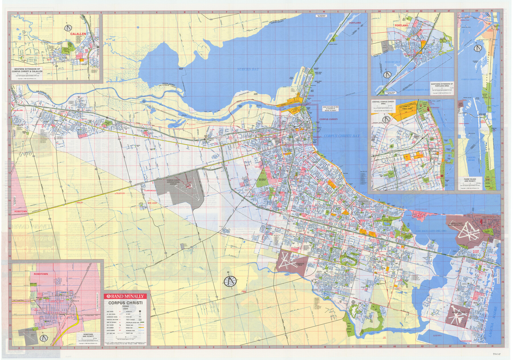
Corpus Christi
[Recto: Corpus Christi and inset maps of Calallen, Robstown, Portland, Padre Island, and Central Corpus Christi]
-
Map/Doc
94428
-
Collection
General Map Collection
-
Object Dates
1995 (Copyright Date)
-
People and Organizations
Rand McNally & Co. (Publisher)
-
Counties
Nueces
-
Subjects
City
-
Height x Width
26.0 x 37.0 inches
66.0 x 94.0 cm
-
Medium
paper, etching/engraving/lithograph
-
Scale
1 inch = approx .70 mile
-
Comments
See 94429 for information about Corpus Christi and inset maps of Nueces County, Padre Isles, Corpus Christi Market Area, and Port Aransas on verso.
Related maps

Part of: General Map Collection
Flight Mission No. DAG-21K, Frame 85, Matagorda County

Print $20.00
- Digital $50.00
Flight Mission No. DAG-21K, Frame 85, Matagorda County
1952
Size 18.5 x 22.3 inches
Map/Doc 86414
Lynn County Boundary File 9

Print $24.00
- Digital $50.00
Lynn County Boundary File 9
Size 11.3 x 8.8 inches
Map/Doc 56657
Wilbarger Co.

Print $40.00
- Digital $50.00
Wilbarger Co.
1907
Size 48.8 x 39.8 inches
Map/Doc 63127
Pecos County Rolled Sketch 176

Print $20.00
- Digital $50.00
Pecos County Rolled Sketch 176
1978
Size 14.1 x 33.6 inches
Map/Doc 7296
Hansford County Working Sketch 2

Print $40.00
- Digital $50.00
Hansford County Working Sketch 2
1934
Size 42.7 x 54.4 inches
Map/Doc 63374
Bexar County Sketch File 36c

Print $20.00
- Digital $50.00
Bexar County Sketch File 36c
1874
Size 19.3 x 26.4 inches
Map/Doc 10922
Brazos River, Brazos River Sheet 3

Print $6.00
- Digital $50.00
Brazos River, Brazos River Sheet 3
1926
Size 23.6 x 35.2 inches
Map/Doc 65295
Reeves County Sketch File 12

Print $20.00
- Digital $50.00
Reeves County Sketch File 12
Size 42.7 x 31.3 inches
Map/Doc 10588
Flight Mission No. CGI-3N, Frame 104, Cameron County

Print $20.00
- Digital $50.00
Flight Mission No. CGI-3N, Frame 104, Cameron County
1954
Size 18.6 x 22.3 inches
Map/Doc 84584
Hansford County

Print $20.00
- Digital $50.00
Hansford County
1932
Size 41.8 x 39.8 inches
Map/Doc 1847
Gregg County Sketch File 4a

Print $4.00
- Digital $50.00
Gregg County Sketch File 4a
1848
Size 12.7 x 8.1 inches
Map/Doc 24572
Gaines County Rolled Sketch 20

Print $20.00
- Digital $50.00
Gaines County Rolled Sketch 20
1955
Size 30.1 x 37.2 inches
Map/Doc 5936
You may also like
Hardin County

Print $20.00
- Digital $50.00
Hardin County
1940
Size 40.7 x 37.7 inches
Map/Doc 77303
General Highway Map, Grimes County, Texas

Print $20.00
General Highway Map, Grimes County, Texas
1940
Size 25.0 x 18.4 inches
Map/Doc 79106
Fisher County

Print $40.00
- Digital $50.00
Fisher County
1944
Size 50.2 x 44.2 inches
Map/Doc 95497
Map of Town Tract of Refugio

Print $20.00
- Digital $50.00
Map of Town Tract of Refugio
1879
Size 25.4 x 24.5 inches
Map/Doc 4829
Letter from Jesse Grimes Suggesting a Redefinition of the Boundary Between Harris and Montgomery Counties, April 30, 1838

Print $20.00
Letter from Jesse Grimes Suggesting a Redefinition of the Boundary Between Harris and Montgomery Counties, April 30, 1838
2020
Size 15.4 x 21.7 inches
Map/Doc 96381
The State of Oklahoma

Print $20.00
- Digital $50.00
The State of Oklahoma
1916
Size 28.4 x 34.4 inches
Map/Doc 97104
Brewster County Sketch File NS-4b

Print $40.00
- Digital $50.00
Brewster County Sketch File NS-4b
Size 30.4 x 35.8 inches
Map/Doc 10988
Hutchinson County Rolled Sketch 41

Print $40.00
- Digital $50.00
Hutchinson County Rolled Sketch 41
1989
Size 43.3 x 144.5 inches
Map/Doc 9249
[Skletch filed with corrected field notes of Surveys 27, 28, 29 and 30, Block B-19 Public School Lands]
![93056, [Skletch filed with corrected field notes of Surveys 27, 28, 29 and 30, Block B-19 Public School Lands], Twichell Survey Records](https://historictexasmaps.com/wmedia_w700/maps/93056-1.tif.jpg)
Print $20.00
- Digital $50.00
[Skletch filed with corrected field notes of Surveys 27, 28, 29 and 30, Block B-19 Public School Lands]
1943
Size 19.3 x 15.4 inches
Map/Doc 93056
Frio County Working Sketch 27

Print $20.00
- Digital $50.00
Frio County Working Sketch 27
Size 25.3 x 36.8 inches
Map/Doc 78193
Kleberg County Rolled Sketch 10-31

Print $20.00
- Digital $50.00
Kleberg County Rolled Sketch 10-31
1952
Size 37.9 x 40.3 inches
Map/Doc 9398
