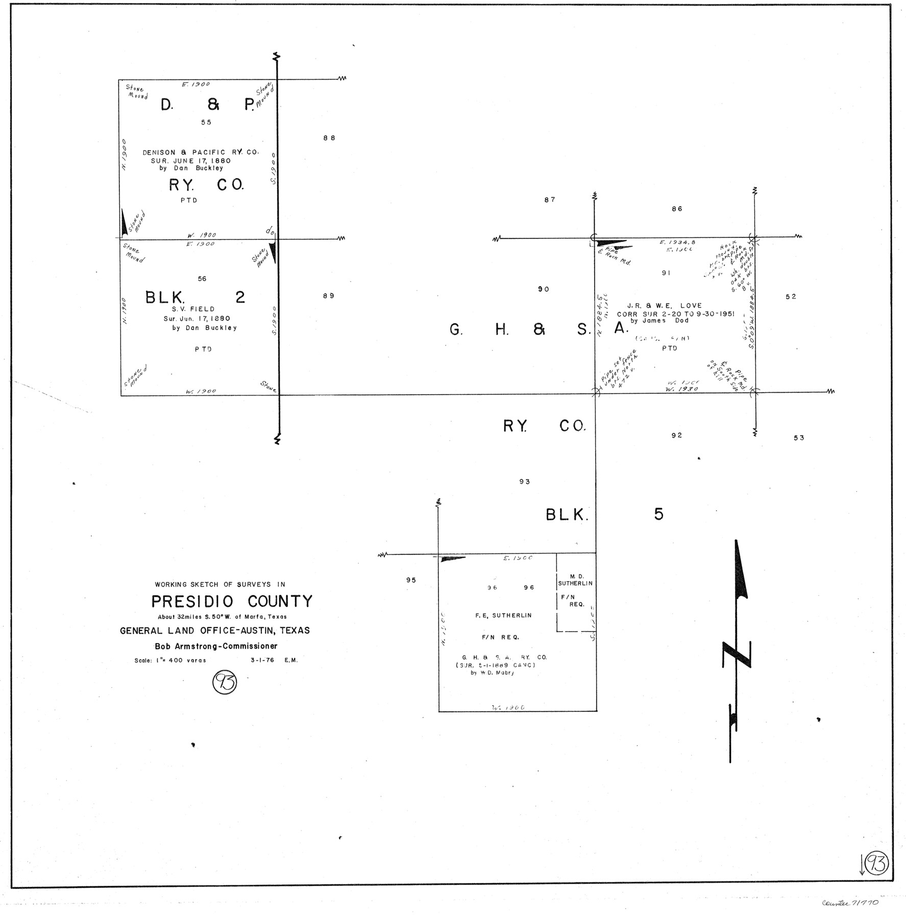
Presidio County Working Sketch 93
-
Map/Doc
71770
-
Collection
General Map Collection
-
Object Dates
3/1/1976 (Creation Date)
-
People and Organizations
Elbert Menzel (Draftsman)
-
Counties
Presidio
-
Subjects
Surveying Working Sketch
-
Height x Width
27.7 x 27.3 inches
70.4 x 69.3 cm
-
Scale
1" = 400 varas
Part of: General Map Collection
Map of Donley County

Print $20.00
- Digital $50.00
Map of Donley County
1894
Size 44.6 x 35.8 inches
Map/Doc 16823
Fort Bend County Sketch File 7

Print $4.00
- Digital $50.00
Fort Bend County Sketch File 7
1876
Size 12.9 x 8.0 inches
Map/Doc 22892
Tarrant County Boundary File 2

Print $6.00
- Digital $50.00
Tarrant County Boundary File 2
Size 14.4 x 9.0 inches
Map/Doc 59111
Current Miscellaneous File 71

Print $8.00
- Digital $50.00
Current Miscellaneous File 71
Size 11.2 x 8.8 inches
Map/Doc 74155
Flight Mission No. BRA-16M, Frame 51, Jefferson County

Print $20.00
- Digital $50.00
Flight Mission No. BRA-16M, Frame 51, Jefferson County
1953
Size 18.6 x 22.6 inches
Map/Doc 85668
Loving County Working Sketch 9

Print $20.00
- Digital $50.00
Loving County Working Sketch 9
1952
Size 24.8 x 45.8 inches
Map/Doc 70641

Zavala County Working Sketch 19

Print $40.00
- Digital $50.00
Zavala County Working Sketch 19
1978
Size 16.2 x 59.1 inches
Map/Doc 62094
Dallas County Boundary File 6b

Print $40.00
- Digital $50.00
Dallas County Boundary File 6b
Size 14.1 x 8.6 inches
Map/Doc 52207
McMullen County Working Sketch 33

Print $20.00
- Digital $50.00
McMullen County Working Sketch 33
1959
Size 37.3 x 27.0 inches
Map/Doc 70734
Red River County Sketch File 5

Print $4.00
- Digital $50.00
Red River County Sketch File 5
Size 7.9 x 4.8 inches
Map/Doc 35102
Castro County Sketch File 9

Print $4.00
- Digital $50.00
Castro County Sketch File 9
1908
Size 11.2 x 8.6 inches
Map/Doc 17499
You may also like
Comanche County Sketch File 20

Print $40.00
- Digital $50.00
Comanche County Sketch File 20
Size 15.5 x 12.6 inches
Map/Doc 19103
Kimble County Rolled Sketch 24

Print $20.00
- Digital $50.00
Kimble County Rolled Sketch 24
1934
Size 31.6 x 17.7 inches
Map/Doc 6514
Dickens County Sketch File 1a

Print $40.00
- Digital $50.00
Dickens County Sketch File 1a
1879
Size 16.8 x 13.8 inches
Map/Doc 20948
Burnet County Sketch File 44

Print $10.00
- Digital $50.00
Burnet County Sketch File 44
1936
Size 11.3 x 8.8 inches
Map/Doc 16767
Cass County Working Sketch 45

Print $20.00
- Digital $50.00
Cass County Working Sketch 45
1989
Size 21.3 x 30.1 inches
Map/Doc 67948
Presidio County Sketch File 92

Print $10.00
- Digital $50.00
Presidio County Sketch File 92
1958
Size 11.2 x 8.8 inches
Map/Doc 34765
Gray County Boundary File 4

Print $34.00
- Digital $50.00
Gray County Boundary File 4
Size 11.4 x 8.9 inches
Map/Doc 53876
Texas Official Travel Map

Digital $50.00
Texas Official Travel Map
Size 33.6 x 36.5 inches
Map/Doc 94301
Hudspeth County Rolled Sketch 50

Print $40.00
- Digital $50.00
Hudspeth County Rolled Sketch 50
1971
Size 56.6 x 34.8 inches
Map/Doc 9220
[Beaumont, Sour Lake and Western Ry. Right of Way and Alignment - Frisco]
![64115, [Beaumont, Sour Lake and Western Ry. Right of Way and Alignment - Frisco], General Map Collection](https://historictexasmaps.com/wmedia_w700/maps/64115.tif.jpg)
Print $20.00
- Digital $50.00
[Beaumont, Sour Lake and Western Ry. Right of Way and Alignment - Frisco]
1910
Size 20.1 x 45.9 inches
Map/Doc 64115
Galveston County NRC Article 33.136 Location Key Sheet

Print $20.00
- Digital $50.00
Galveston County NRC Article 33.136 Location Key Sheet
1995
Size 27.0 x 22.0 inches
Map/Doc 83592
Flight Mission No. DQO-7K, Frame 113, Galveston County

Print $20.00
- Digital $50.00
Flight Mission No. DQO-7K, Frame 113, Galveston County
1952
Size 18.7 x 22.3 inches
Map/Doc 85128