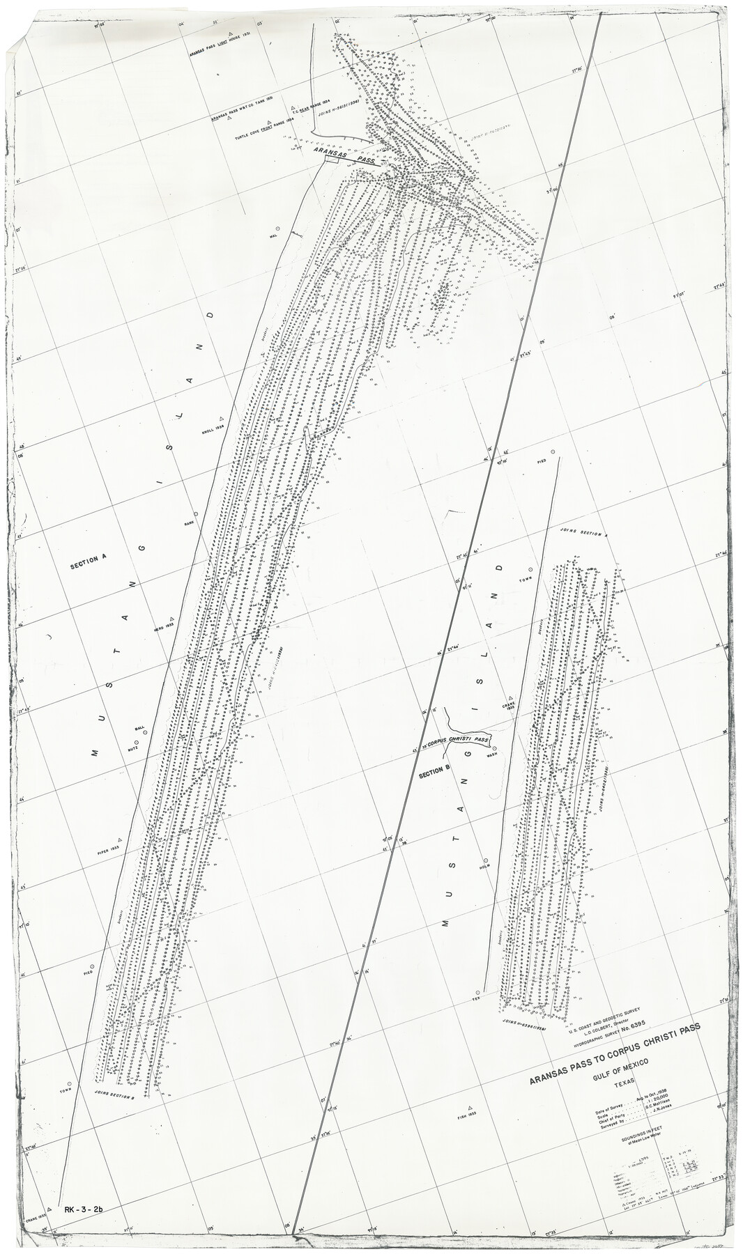
Hydrographic Survey H-6395 of Outer Coast of Padre Island; Gulf of Mexico
True photographic copy from National Ocean Survey
-
Map/Doc
2697
-
Collection
General Map Collection
-
Object Dates
1938 (Creation Date)
-
People and Organizations
U. S. Coast and Geodetic Survey (Author)
-
Counties
Aransas San Patricio Nueces
-
Subjects
Nautical Charts
-
Height x Width
55.1 x 33.3 inches
140.0 x 84.6 cm
-
Medium
photograph
-
Scale
1:20,000
Part of: General Map Collection
Cherokee County Sketch File 28

Print $6.00
- Digital $50.00
Cherokee County Sketch File 28
1916
Size 11.0 x 14.0 inches
Map/Doc 18173
Presidio County Rolled Sketch 74

Print $20.00
- Digital $50.00
Presidio County Rolled Sketch 74
Size 20.5 x 14.0 inches
Map/Doc 7362
[F. W. & D. C. Ry. Co. Alignment and Right of Way Map, Clay County]
![64737, [F. W. & D. C. Ry. Co. Alignment and Right of Way Map, Clay County], General Map Collection](https://historictexasmaps.com/wmedia_w700/maps/64737-GC.tif.jpg)
Print $20.00
- Digital $50.00
[F. W. & D. C. Ry. Co. Alignment and Right of Way Map, Clay County]
1927
Size 18.6 x 11.8 inches
Map/Doc 64737
Map of Bexar County

Print $20.00
- Digital $50.00
Map of Bexar County
1896
Size 45.2 x 40.2 inches
Map/Doc 4885
Carson County Boundary File 3

Print $2.00
- Digital $50.00
Carson County Boundary File 3
Size 13.3 x 8.3 inches
Map/Doc 51131
Travis County Appraisal District Plat Map 2_3013

Print $20.00
- Digital $50.00
Travis County Appraisal District Plat Map 2_3013
Size 21.5 x 26.4 inches
Map/Doc 94220
Terrell County Rolled Sketch 51A

Print $20.00
- Digital $50.00
Terrell County Rolled Sketch 51A
1957
Size 29.1 x 20.6 inches
Map/Doc 7968
Nueces County Rolled Sketch 50

Print $20.00
- Digital $50.00
Nueces County Rolled Sketch 50
1939
Size 21.9 x 38.0 inches
Map/Doc 9605
Railroad Track Map, H&TCRRCo., Falls County, Texas

Print $4.00
- Digital $50.00
Railroad Track Map, H&TCRRCo., Falls County, Texas
1918
Size 11.9 x 18.5 inches
Map/Doc 62832
Bandera County Sketch File 31

Print $40.00
- Digital $50.00
Bandera County Sketch File 31
1949
Size 17.7 x 22.2 inches
Map/Doc 10900
[Map of Nueces Bay Showing Old Leases]
![2924, [Map of Nueces Bay Showing Old Leases], General Map Collection](https://historictexasmaps.com/wmedia_w700/maps/2924-1.tif.jpg)
Print $20.00
- Digital $50.00
[Map of Nueces Bay Showing Old Leases]
1936
Size 18.0 x 22.9 inches
Map/Doc 2924
(A No. 2) Preliminary Sketch Showing the positions of Davis's South Shoal and other Dangers recently discovered by the Coast Survey and the soundings on the Old South Shoal, Bass Rip, Old Man, Pochick Rip &c.

Print $20.00
- Digital $50.00
(A No. 2) Preliminary Sketch Showing the positions of Davis's South Shoal and other Dangers recently discovered by the Coast Survey and the soundings on the Old South Shoal, Bass Rip, Old Man, Pochick Rip &c.
1846
Size 19.7 x 21.8 inches
Map/Doc 97203
You may also like
Palo Pinto County Working Sketch 26

Print $20.00
- Digital $50.00
Palo Pinto County Working Sketch 26
1993
Map/Doc 71409
Orange County Rolled Sketch RG

Print $40.00
- Digital $50.00
Orange County Rolled Sketch RG
1919
Size 32.7 x 61.2 inches
Map/Doc 9654
Gaines County Boundary File 4

Print $4.00
- Digital $50.00
Gaines County Boundary File 4
Size 14.4 x 8.9 inches
Map/Doc 53656
Flight Mission No. DAG-17K, Frame 76, Matagorda County

Print $20.00
- Digital $50.00
Flight Mission No. DAG-17K, Frame 76, Matagorda County
1952
Size 16.6 x 16.6 inches
Map/Doc 86335
Galveston County Rolled Sketch 49

Print $20.00
- Digital $50.00
Galveston County Rolled Sketch 49
2018
Size 30.9 x 22.6 inches
Map/Doc 95386
[Blocks T1, T2, T3, Leagues 574, 575, 634- 637

Print $20.00
- Digital $50.00
[Blocks T1, T2, T3, Leagues 574, 575, 634- 637
Size 30.2 x 33.5 inches
Map/Doc 91051
Newton County Working Sketch 17

Print $20.00
- Digital $50.00
Newton County Working Sketch 17
1950
Size 15.1 x 23.0 inches
Map/Doc 71263
Parker County Working Sketch 19-2

Print $20.00
- Digital $50.00
Parker County Working Sketch 19-2
2005
Map/Doc 83580
Dimmit County Working Sketch 57

Print $20.00
- Digital $50.00
Dimmit County Working Sketch 57
2008
Size 26.1 x 31.7 inches
Map/Doc 88847
Lavaca County

Print $40.00
- Digital $50.00
Lavaca County
1946
Size 50.9 x 40.6 inches
Map/Doc 77349
Maps of Gulf Intracoastal Waterway, Texas - Sabine River to the Rio Grande and connecting waterways including ship channels

Print $20.00
- Digital $50.00
Maps of Gulf Intracoastal Waterway, Texas - Sabine River to the Rio Grande and connecting waterways including ship channels
1966
Size 14.5 x 22.2 inches
Map/Doc 61922
Map of Littlefield's Subdivision of State Capitol Leagues 657- 687

Print $20.00
- Digital $50.00
Map of Littlefield's Subdivision of State Capitol Leagues 657- 687
Size 38.0 x 29.2 inches
Map/Doc 91025