Galveston County Rolled Sketch 49
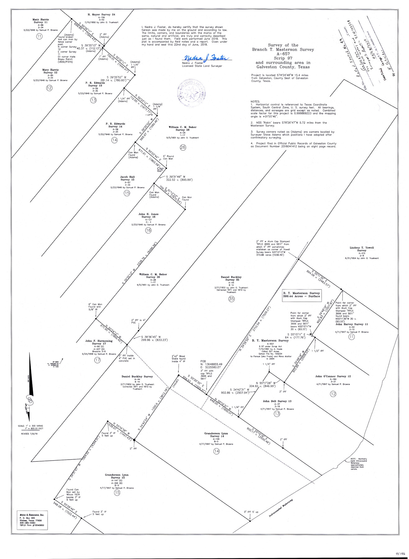
Survey of the Branch T. Masterson survey A-657 Scrip 97 and surrounding area in Galveston County, Texas
-
Map/Doc
95386
-
Collection
General Map Collection
-
Object Dates
2018/6/22 (Creation Date)
2019/3/28 (File Date)
-
People and Organizations
Nedra J. Foster (Surveyor/Engineer)
-
Counties
Galveston
-
Subjects
Surveying Rolled Sketch
-
Height x Width
30.9 x 22.6 inches
78.5 x 57.4 cm
-
Medium
mylar, print
-
Scale
1" = 300 varas
-
Comments
See field notes and surveyor's report in School File 155234.
Part of: General Map Collection
Pecos County Rolled Sketch 113

Print $20.00
- Digital $50.00
Pecos County Rolled Sketch 113
1942
Size 31.9 x 35.4 inches
Map/Doc 9721
Colorado County Working Sketch 33

Print $20.00
- Digital $50.00
Colorado County Working Sketch 33
1988
Size 38.7 x 32.4 inches
Map/Doc 68133
Sabine Bank to East Bay including Heald Bank

Print $20.00
- Digital $50.00
Sabine Bank to East Bay including Heald Bank
1982
Size 44.8 x 34.3 inches
Map/Doc 69852
Gillespie County Working Sketch 13

Print $20.00
- Digital $50.00
Gillespie County Working Sketch 13
2008
Size 22.8 x 31.8 inches
Map/Doc 88831
Dallam County Sketch File A

Print $20.00
- Digital $50.00
Dallam County Sketch File A
1903
Size 32.3 x 20.9 inches
Map/Doc 11281
Limestone County Sketch File 24

Print $8.00
- Digital $50.00
Limestone County Sketch File 24
1942
Size 11.2 x 8.8 inches
Map/Doc 30206
Caldwell County Rolled Sketch 1

Print $20.00
- Digital $50.00
Caldwell County Rolled Sketch 1
1953
Size 20.2 x 30.4 inches
Map/Doc 10673
Sulphur River, Ringo Crossing Sheet

Print $20.00
- Digital $50.00
Sulphur River, Ringo Crossing Sheet
1933
Size 18.5 x 20.4 inches
Map/Doc 78334
Brewster County Working Sketch 45

Print $40.00
- Digital $50.00
Brewster County Working Sketch 45
1948
Size 53.6 x 36.1 inches
Map/Doc 67579
McLennan County Sketch File 31

Print $22.00
- Digital $50.00
McLennan County Sketch File 31
Size 14.2 x 17.2 inches
Map/Doc 31306
[Right of Way & Track Map, The Texas & Pacific Ry. Co. Main Line]
![64691, [Right of Way & Track Map, The Texas & Pacific Ry. Co. Main Line], General Map Collection](https://historictexasmaps.com/wmedia_w700/maps/64691.tif.jpg)
Print $20.00
- Digital $50.00
[Right of Way & Track Map, The Texas & Pacific Ry. Co. Main Line]
Size 10.9 x 18.6 inches
Map/Doc 64691
Tom Green County Sketch File 84

Print $20.00
- Digital $50.00
Tom Green County Sketch File 84
1890
Size 20.6 x 18.5 inches
Map/Doc 12456
You may also like
Lamb County Working Sketch 1

Print $20.00
- Digital $50.00
Lamb County Working Sketch 1
1917
Size 40.2 x 43.4 inches
Map/Doc 70274
Jefferson County Sketch File 39

Print $20.00
- Digital $50.00
Jefferson County Sketch File 39
Size 14.3 x 8.7 inches
Map/Doc 28218
[E.L.R.R.R.R.Co. Blocks A-1, 1, H, Y, Public School Land Blocks C-40, C-41, C-39, C-42]
![92904, [E.L.R.R.R.R.Co. Blocks A-1, 1, H, Y, Public School Land Blocks C-40, C-41, C-39, C-42], Twichell Survey Records](https://historictexasmaps.com/wmedia_w700/maps/92904-1.tif.jpg)
Print $20.00
- Digital $50.00
[E.L.R.R.R.R.Co. Blocks A-1, 1, H, Y, Public School Land Blocks C-40, C-41, C-39, C-42]
Size 21.6 x 21.2 inches
Map/Doc 92904
Potter County Working Sketch 2

Print $40.00
- Digital $50.00
Potter County Working Sketch 2
1919
Size 43.3 x 54.4 inches
Map/Doc 71662
Flight Mission No. DQO-8K, Frame 142, Galveston County

Print $20.00
- Digital $50.00
Flight Mission No. DQO-8K, Frame 142, Galveston County
1952
Size 18.6 x 22.3 inches
Map/Doc 85204
Hudspeth County Sketch File 40

Print $8.00
- Digital $50.00
Hudspeth County Sketch File 40
1944
Size 11.2 x 8.6 inches
Map/Doc 27012
Flight Mission No. BRA-7M, Frame 87, Jefferson County

Print $20.00
- Digital $50.00
Flight Mission No. BRA-7M, Frame 87, Jefferson County
1953
Size 18.5 x 22.3 inches
Map/Doc 85509
McMullen County Rolled Sketch JR

Print $20.00
- Digital $50.00
McMullen County Rolled Sketch JR
Size 29.6 x 29.6 inches
Map/Doc 6737
Uvalde County Working Sketch 61

Print $20.00
- Digital $50.00
Uvalde County Working Sketch 61
1978
Size 40.4 x 37.4 inches
Map/Doc 72131
Coke County Rolled Sketch 16

Print $20.00
- Digital $50.00
Coke County Rolled Sketch 16
1950
Size 44.0 x 34.3 inches
Map/Doc 8630
Culberson County Working Sketch 10

Print $20.00
- Digital $50.00
Culberson County Working Sketch 10
1915
Size 28.9 x 31.0 inches
Map/Doc 68462
Webb County Sketch File 14b

Print $4.00
- Digital $50.00
Webb County Sketch File 14b
1897
Size 11.2 x 8.8 inches
Map/Doc 39812