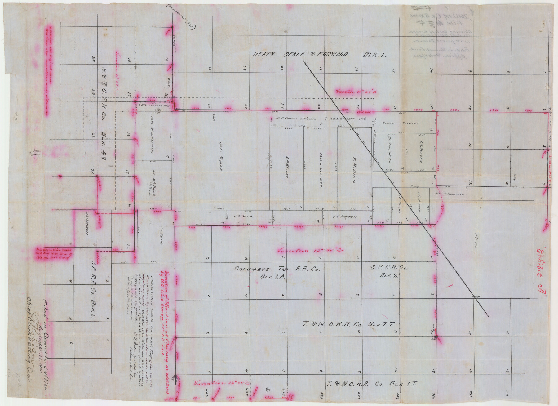
Dallam County Sketch File A
Showing surveys around the Joel Moore League in S. E. part of Dallam Co.
-
Map/Doc
11281
-
Collection
General Map Collection
-
Object Dates
1903/11/2 (Creation Date)
1903/11/11 (File Date)
1902/3/3 (Survey Date)
-
People and Organizations
A.L. Turner (Surveyor/Engineer)
E.F. Batte (Surveyor/Engineer)
-
Counties
Dallam
-
Subjects
Surveying Sketch File
-
Height x Width
32.3 x 20.9 inches
82.0 x 53.1 cm
-
Medium
paper, photocopy
Part of: General Map Collection
Crockett County Working Sketch 56

Print $20.00
- Digital $50.00
Crockett County Working Sketch 56
1947
Size 28.5 x 46.7 inches
Map/Doc 68389
Dallas County Sketch File 20

Print $4.00
- Digital $50.00
Dallas County Sketch File 20
Size 12.2 x 7.8 inches
Map/Doc 20441
Calhoun County Rolled Sketch 36

Print $40.00
- Digital $50.00
Calhoun County Rolled Sketch 36
2003
Size 33.3 x 49.0 inches
Map/Doc 78655
Brewster County Working Sketch 2

Print $20.00
- Digital $50.00
Brewster County Working Sketch 2
1907
Size 29.0 x 26.4 inches
Map/Doc 67535
Webb County Rolled Sketch 47

Print $20.00
- Digital $50.00
Webb County Rolled Sketch 47
Size 23.5 x 31.7 inches
Map/Doc 8203
Culberson County Rolled Sketch 69

Print $20.00
- Digital $50.00
Culberson County Rolled Sketch 69
Size 33.5 x 22.9 inches
Map/Doc 76425
Kinney County Sketch File 40

Print $6.00
Kinney County Sketch File 40
Size 14.0 x 8.5 inches
Map/Doc 97247
Lampasas County Boundary File 10

Print $11.00
- Digital $50.00
Lampasas County Boundary File 10
Size 12.8 x 7.9 inches
Map/Doc 56184
Colorado County Working Sketch 1

Print $20.00
- Digital $50.00
Colorado County Working Sketch 1
1897
Size 16.2 x 21.3 inches
Map/Doc 68101

San Jacinto County Working Sketch 36

Print $40.00
- Digital $50.00
San Jacinto County Working Sketch 36
1964
Size 33.0 x 57.2 inches
Map/Doc 63749
Ward County Rolled Sketch 1

Print $40.00
- Digital $50.00
Ward County Rolled Sketch 1
1888
Size 42.6 x 120.4 inches
Map/Doc 76165
You may also like
Fort Bend County

Print $20.00
- Digital $50.00
Fort Bend County
1882
Size 21.4 x 22.7 inches
Map/Doc 3554
Galveston County Sketch File 19

Print $4.00
- Digital $50.00
Galveston County Sketch File 19
Size 9.3 x 7.3 inches
Map/Doc 23390
United States - Gulf Coast - Padre I. and Laguna Madre Lat. 27° 12' to Lat. 26° 33' Texas

Print $20.00
- Digital $50.00
United States - Gulf Coast - Padre I. and Laguna Madre Lat. 27° 12' to Lat. 26° 33' Texas
1913
Size 26.9 x 18.2 inches
Map/Doc 72820
Right-of-way & Track Map Dawson Railway Operated by the El Paso & Southwestern Company Station 360+75.4 to Station 149+55.4

Print $40.00
- Digital $50.00
Right-of-way & Track Map Dawson Railway Operated by the El Paso & Southwestern Company Station 360+75.4 to Station 149+55.4
1910
Size 56.8 x 24.7 inches
Map/Doc 89660
Map of the New England or Eastern States (Inset 1: Map of New Brunswick, Nova Scotia and Newfoundland / Inset 2: Vicinity of Boston and Providence / Inset 3: Vicinity of New Haven and Hartford)

Print $20.00
- Digital $50.00
Map of the New England or Eastern States (Inset 1: Map of New Brunswick, Nova Scotia and Newfoundland / Inset 2: Vicinity of Boston and Providence / Inset 3: Vicinity of New Haven and Hartford)
1844
Size 17.8 x 11.8 inches
Map/Doc 93495
Duval County Rolled Sketch 37

Print $20.00
- Digital $50.00
Duval County Rolled Sketch 37
1952
Size 29.2 x 24.6 inches
Map/Doc 5753
McLennan County Working Sketch Graphic Index

Print $20.00
- Digital $50.00
McLennan County Working Sketch Graphic Index
1946
Size 41.8 x 44.8 inches
Map/Doc 76637
Current Miscellaneous File 15

Print $16.00
- Digital $50.00
Current Miscellaneous File 15
1951
Size 10.7 x 8.2 inches
Map/Doc 73822
Knox County Sketch File 24

Print $6.00
- Digital $50.00
Knox County Sketch File 24
1945
Size 14.2 x 9.0 inches
Map/Doc 29254
Jefferson County Sketch File 46

Print $20.00
- Digital $50.00
Jefferson County Sketch File 46
1933
Size 20.8 x 31.2 inches
Map/Doc 11880
Presidio County Sketch File 44

Print $15.00
- Digital $50.00
Presidio County Sketch File 44
1913
Size 11.1 x 9.5 inches
Map/Doc 34525
Kerr County Working Sketch 12

Print $20.00
- Digital $50.00
Kerr County Working Sketch 12
1951
Size 34.3 x 37.0 inches
Map/Doc 70043