Jefferson County Sketch File 39
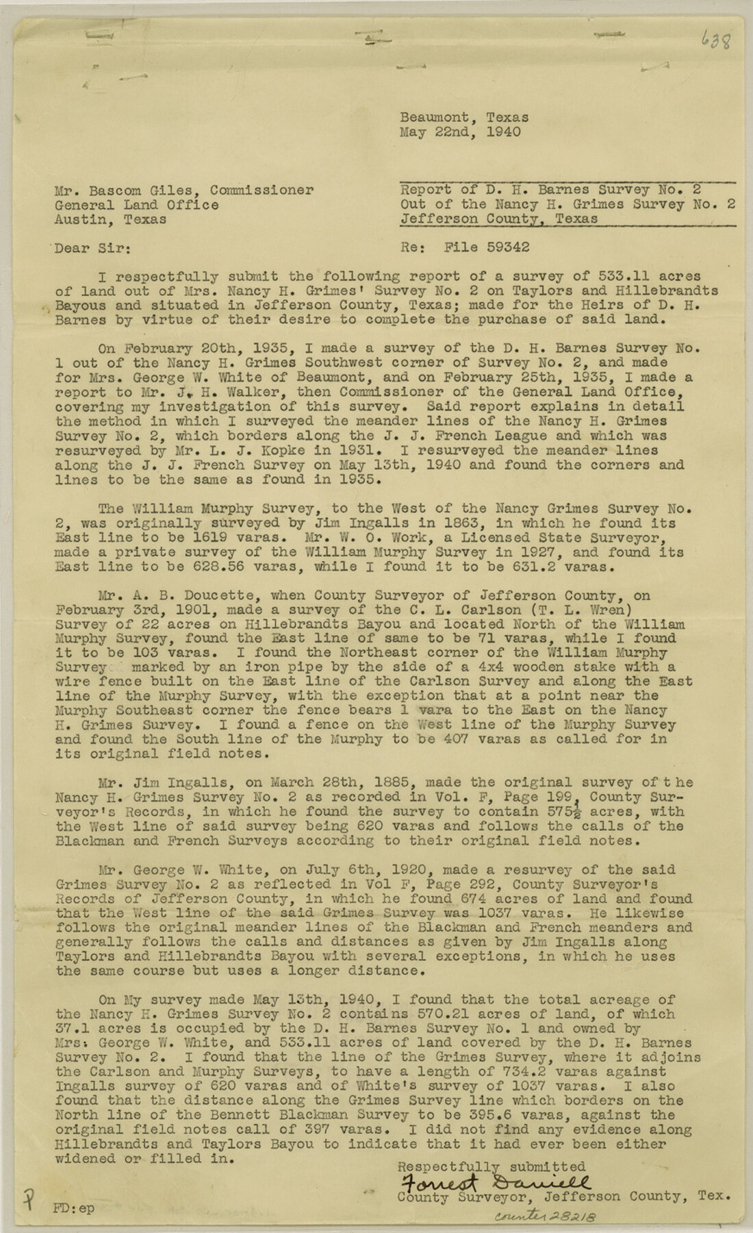
[Report of D.H. Barnes survey no. 2 out of N.H. Grimes survey no. 2, Taylor's Bayou]
-
Map/Doc
28218
-
Collection
General Map Collection
-
Object Dates
6/26/1940 (File Date)
5/22/1940 (Correspondence Date)
1931 (Survey Date)
5/13/1940 (Survey Date)
5/26/1863 (Survey Date)
1927 (Survey Date)
2/3/1901 (Survey Date)
3/28/1885 (Survey Date)
7/6/1920 (Survey Date)
2/3/1901 (Survey Date)
-
People and Organizations
Forrest Daniell (Surveyor/Engineer)
L.J. Kopke (Surveyor/Engineer)
Jim Ingalls (Surveyor/Engineer)
W.O. Work (Surveyor/Engineer)
A.B. Doucette (Surveyor/Engineer)
George W. White (Surveyor/Engineer)
Charley Dow (Chainman)
Robert Lee (Chainman)
C.H. Rowley (Chainman)
Lewis Wendling (Chainman)
Espa Hillebrant (Chainman)
Joseph Ellender (Chainman)
Garnett Phillips (Chainman)
David Durham (Chainman)
Will Crawford (Chainman)
H. Fox (Chainman)
-
Counties
Jefferson
-
Subjects
Surveying Sketch File
-
Height x Width
14.3 x 8.7 inches
36.3 x 22.1 cm
-
Medium
paper, print
-
Comments
See Jefferson County Rolled Sketch 24 (6388) for sketch.
-
Features
Taylor's Bayou
Hillebrandts Bayou
Sabine River
Sabine Lake
Labelle Road
Related maps
Jefferson County Rolled Sketch 24

Print $20.00
- Digital $50.00
Jefferson County Rolled Sketch 24
1940
Size 30.3 x 27.8 inches
Map/Doc 6388
Part of: General Map Collection
[Photostats of section of Hydrographic Surveys H-5399, H-4822 and H-470, Mouth of Trinity River]
![61154, [Photostats of section of Hydrographic Surveys H-5399, H-4822 and H-470, Mouth of Trinity River], General Map Collection](https://historictexasmaps.com/wmedia_w700/maps/61154.tif.jpg)
Print $20.00
- Digital $50.00
[Photostats of section of Hydrographic Surveys H-5399, H-4822 and H-470, Mouth of Trinity River]
1933
Size 18.2 x 25.8 inches
Map/Doc 61154
Menard County Boundary File 2

Print $38.00
- Digital $50.00
Menard County Boundary File 2
Size 8.9 x 9.1 inches
Map/Doc 57046

Fort Bend County Sketch File 8

Print $6.00
- Digital $50.00
Fort Bend County Sketch File 8
Size 6.3 x 4.2 inches
Map/Doc 22894
Matagorda Light to Aransas Pass

Print $20.00
- Digital $50.00
Matagorda Light to Aransas Pass
1974
Size 36.5 x 45.3 inches
Map/Doc 73401
Upton County Rolled Sketch 31

Print $40.00
- Digital $50.00
Upton County Rolled Sketch 31
Size 27.2 x 53.4 inches
Map/Doc 10048
Kaufman County

Print $20.00
- Digital $50.00
Kaufman County
1942
Size 44.5 x 36.7 inches
Map/Doc 77335
Map of Nacogdoches County

Print $20.00
- Digital $50.00
Map of Nacogdoches County
1881
Size 24.5 x 21.8 inches
Map/Doc 4604
Matagorda County NRC Article 33.136 Sketch 20

Print $106.00
Matagorda County NRC Article 33.136 Sketch 20
2024
Map/Doc 97425
Parker County Sketch File 36

Print $7.00
- Digital $50.00
Parker County Sketch File 36
Size 9.1 x 7.8 inches
Map/Doc 33578
Polk County Working Sketch 1

Print $20.00
- Digital $50.00
Polk County Working Sketch 1
Size 13.1 x 16.4 inches
Map/Doc 71616
Brazoria County Working Sketch 45

Print $20.00
- Digital $50.00
Brazoria County Working Sketch 45
1988
Size 23.0 x 19.2 inches
Map/Doc 67530
You may also like
Brewster County Sketch File NS-4f

Print $8.00
- Digital $50.00
Brewster County Sketch File NS-4f
Size 8.9 x 11.3 inches
Map/Doc 15977
Bexar County State Real Property Sketch 5

Print $40.00
- Digital $50.00
Bexar County State Real Property Sketch 5
2019
Size 48.0 x 35.8 inches
Map/Doc 95710
Starr County Sketch File 47

Print $6.00
- Digital $50.00
Starr County Sketch File 47
1949
Size 11.2 x 8.8 inches
Map/Doc 37002

General Highway Map of Garza County, Texas

Print $20.00
- Digital $50.00
General Highway Map of Garza County, Texas
1950
Size 25.9 x 18.8 inches
Map/Doc 92646

Shelby County Working Sketch 1

Print $20.00
- Digital $50.00
Shelby County Working Sketch 1
1917
Size 26.2 x 30.0 inches
Map/Doc 63854
General Highway Map, Reeves County, Texas

Print $20.00
General Highway Map, Reeves County, Texas
1940
Size 24.8 x 18.2 inches
Map/Doc 79227
[St. L. S.-W. Ry. of Texas, Map of Lufkin Branch in Smith County, Texas]
![64693, [St. L. S.-W. Ry. of Texas, Map of Lufkin Branch in Smith County, Texas], General Map Collection](https://historictexasmaps.com/wmedia_w700/maps/64693.tif.jpg)
Print $40.00
- Digital $50.00
[St. L. S.-W. Ry. of Texas, Map of Lufkin Branch in Smith County, Texas]
1912
Size 24.2 x 121.2 inches
Map/Doc 64693
Chambers County Sketch File 6

Print $4.00
- Digital $50.00
Chambers County Sketch File 6
1863
Size 9.1 x 8.5 inches
Map/Doc 17540
Brazos River, Brazos River Sheet 2

Print $20.00
- Digital $50.00
Brazos River, Brazos River Sheet 2
1926
Size 22.3 x 29.4 inches
Map/Doc 69666
Hemphill County Working Sketch 14

Print $20.00
- Digital $50.00
Hemphill County Working Sketch 14
1969
Size 34.0 x 44.8 inches
Map/Doc 66109