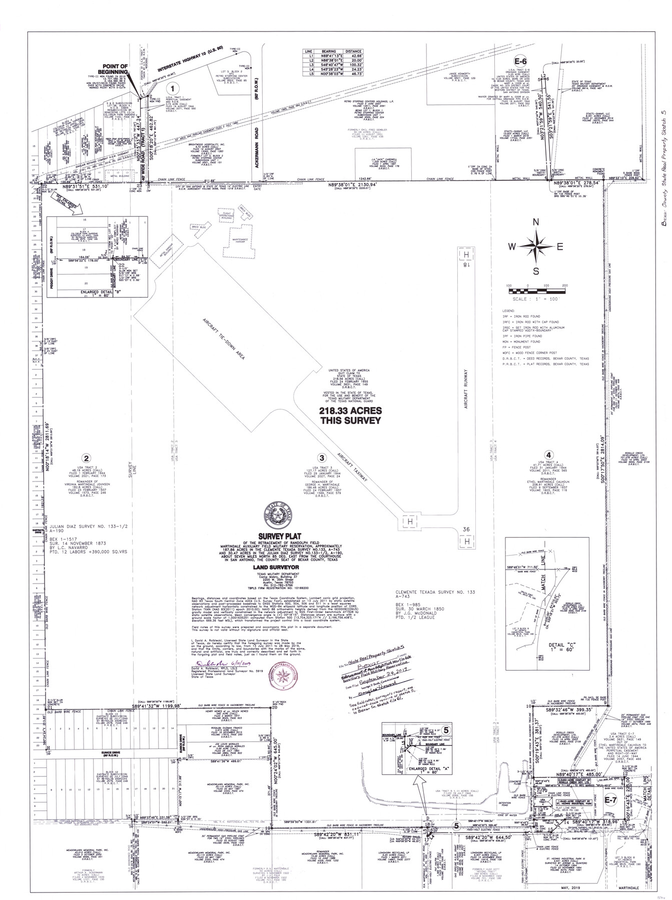
Bexar County State Real Property Sketch 5
Survey plat of the retracement of Randolph Field Martindale Auxiliary Field Military Reservation, approximately 187.86 acres in the Clemente Texada survey no. 133, A-743 and 30.47 acres in the Julian Diaz survey no. 133 1/2, A-190
-
Map/Doc
95710
-
Collection
General Map Collection
-
Object Dates
2019/6/10 (Creation Date)
2019/9/24 (File Date)
-
People and Organizations
David A. Rolbiecki (Surveyor/Engineer)
-
Counties
Bexar
-
Subjects
State Real Property
-
Height x Width
48.0 x 35.8 inches
121.9 x 90.9 cm
-
Medium
mylar, print
-
Scale
1" = 100'
-
Comments
See Bexar County Sketch File 61 (95709) for field notes and surveyor's report
Related maps
Bexar County Sketch File 61

Print $61.00
- Digital $50.00
Bexar County Sketch File 61
2019
Size 11.0 x 8.5 inches
Map/Doc 95709
Part of: General Map Collection

A Map of That Part of Dallas County, lying in Nacogdoches Land District

Print $20.00
- Digital $50.00
A Map of That Part of Dallas County, lying in Nacogdoches Land District
1854
Size 29.9 x 22.6 inches
Map/Doc 4525
Red River County Rolled Sketch 8

Print $20.00
- Digital $50.00
Red River County Rolled Sketch 8
Size 32.5 x 17.3 inches
Map/Doc 7474
Zavala County Working Sketch 12

Print $20.00
- Digital $50.00
Zavala County Working Sketch 12
1956
Size 31.5 x 30.2 inches
Map/Doc 62087
Titus County Sketch File 11

Print $4.00
- Digital $50.00
Titus County Sketch File 11
1872
Size 8.2 x 10.1 inches
Map/Doc 38150
Travis County Rolled Sketch 16

Print $20.00
- Digital $50.00
Travis County Rolled Sketch 16
1940
Size 21.0 x 18.4 inches
Map/Doc 8018
Newton County Aerial Photograph Index Sheet 1

Print $20.00
- Digital $50.00
Newton County Aerial Photograph Index Sheet 1
1953
Size 23.8 x 18.7 inches
Map/Doc 83730
Sabine County Sketch File 7

Print $2.00
Sabine County Sketch File 7
1882
Size 8.6 x 12.7 inches
Map/Doc 35619
Floyd County Working Sketch 2

Print $20.00
- Digital $50.00
Floyd County Working Sketch 2
1911
Size 41.0 x 24.8 inches
Map/Doc 69181
Upton County Sketch File 10

Print $18.00
- Digital $50.00
Upton County Sketch File 10
1919
Size 13.5 x 8.7 inches
Map/Doc 38839

Matagorda County Rolled Sketch PHL

Print $20.00
- Digital $50.00
Matagorda County Rolled Sketch PHL
1937
Size 37.3 x 40.0 inches
Map/Doc 9476
You may also like
Dickens County Working Sketch 2

Print $20.00
- Digital $50.00
Dickens County Working Sketch 2
1914
Size 19.1 x 16.6 inches
Map/Doc 68649
Menard County Sketch File 5

Print $20.00
- Digital $50.00
Menard County Sketch File 5
Size 5.6 x 43.3 inches
Map/Doc 10542

Parker County Sketch File 45

Print $10.00
- Digital $50.00
Parker County Sketch File 45
1935
Size 11.0 x 8.5 inches
Map/Doc 33610
Tom Green County Sketch File 72

Print $20.00
- Digital $50.00
Tom Green County Sketch File 72
1949
Size 24.3 x 28.5 inches
Map/Doc 12448
University Land Block 46, Culberson County, Texas

Print $20.00
- Digital $50.00
University Land Block 46, Culberson County, Texas
1938
Size 35.1 x 22.0 inches
Map/Doc 2410
Duval County Rolled Sketch OS

Print $20.00
- Digital $50.00
Duval County Rolled Sketch OS
1903
Size 36.0 x 31.9 inches
Map/Doc 8803
Yoakum County Sketch File 11

Print $4.00
- Digital $50.00
Yoakum County Sketch File 11
1914
Size 11.3 x 8.9 inches
Map/Doc 40763
Original Town of Nadine, Lea County, New Mexico

Print $20.00
- Digital $50.00
Original Town of Nadine, Lea County, New Mexico
Size 27.1 x 33.5 inches
Map/Doc 92420
Kendall County Working Sketch 27

Print $20.00
- Digital $50.00
Kendall County Working Sketch 27
1994
Size 30.8 x 42.6 inches
Map/Doc 66699
Refugio County Boundary File 5

Print $4.00
- Digital $50.00
Refugio County Boundary File 5
Size 11.2 x 8.6 inches
Map/Doc 58256
Cherokee County Sketch File 20

Print $4.00
- Digital $50.00
Cherokee County Sketch File 20
1876
Size 8.2 x 6.0 inches
Map/Doc 18163