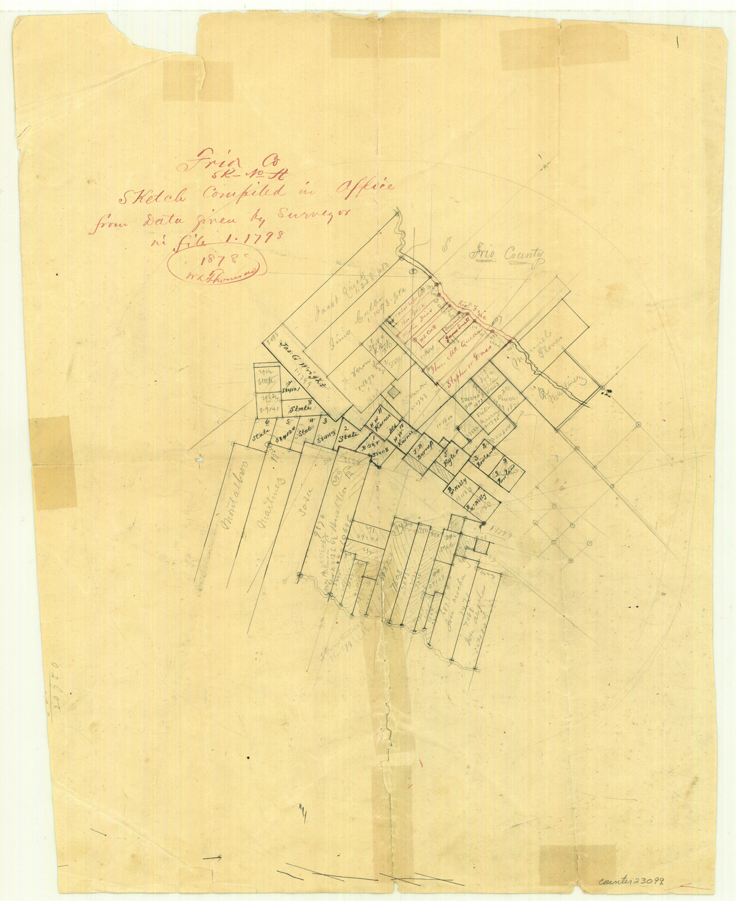
Frio County Sketch File A
[Sketch of surveys on Rio Frio]
-
Map/Doc
23099
-
Collection
General Map Collection
-
Object Dates
1878 (Creation Date)
-
People and Organizations
W.L. Thomas (Surveyor/Engineer)
-
Counties
Frio
-
Subjects
Surveying Sketch File
-
Height x Width
16.4 x 13.4 inches
41.7 x 34.0 cm
-
Medium
paper, manuscript
-
Features
Rio Frio
Part of: General Map Collection
Map of the Galveston, La Porte & Houston Ry. and its Connecting Lines

Print $20.00
- Digital $50.00
Map of the Galveston, La Porte & Houston Ry. and its Connecting Lines
1895
Size 42.6 x 32.0 inches
Map/Doc 64772
Flight Mission No. DQO-11K, Frame 21, Galveston County

Print $20.00
- Digital $50.00
Flight Mission No. DQO-11K, Frame 21, Galveston County
1952
Size 18.6 x 19.7 inches
Map/Doc 85218
[Kansas City, Mexico & Orient] Plat Showing Sections 10 & 17, Block 351, GC & SF Ry. Survey, Presidio County, Texas
![64270, [Kansas City, Mexico & Orient] Plat Showing Sections 10 & 17, Block 351, GC & SF Ry. Survey, Presidio County, Texas, General Map Collection](https://historictexasmaps.com/wmedia_w700/maps/64270-1.tif.jpg)
Print $20.00
- Digital $50.00
[Kansas City, Mexico & Orient] Plat Showing Sections 10 & 17, Block 351, GC & SF Ry. Survey, Presidio County, Texas
Size 17.6 x 16.0 inches
Map/Doc 64270
Liberty County Working Sketch 9

Print $20.00
- Digital $50.00
Liberty County Working Sketch 9
Size 34.6 x 27.3 inches
Map/Doc 70468
Collin County State Real Property Sketch 1

Print $20.00
- Digital $50.00
Collin County State Real Property Sketch 1
2006
Size 24.1 x 35.1 inches
Map/Doc 88634
Coleman County

Print $40.00
- Digital $50.00
Coleman County
1945
Size 55.7 x 37.1 inches
Map/Doc 95458
Val Verde County Sketch File 7

Print $6.00
- Digital $50.00
Val Verde County Sketch File 7
1877
Size 16.9 x 9.7 inches
Map/Doc 39196
Roberts County Sketch File 1

Print $20.00
- Digital $50.00
Roberts County Sketch File 1
Size 39.2 x 22.3 inches
Map/Doc 10589
Palo Pinto County Sketch File 6

Print $40.00
- Digital $50.00
Palo Pinto County Sketch File 6
1875
Size 9.3 x 18.8 inches
Map/Doc 33396
Taylor County Working Sketch 15

Print $20.00
- Digital $50.00
Taylor County Working Sketch 15
1972
Size 44.1 x 30.4 inches
Map/Doc 69625
Bexar County Rolled Sketch 3

Print $20.00
- Digital $50.00
Bexar County Rolled Sketch 3
1873
Size 25.5 x 18.0 inches
Map/Doc 5136
Kimble County Sketch File 13

Print $24.00
- Digital $50.00
Kimble County Sketch File 13
1885
Size 14.1 x 8.6 inches
Map/Doc 28937
You may also like
Roberts County Rolled Sketch 3

Print $40.00
- Digital $50.00
Roberts County Rolled Sketch 3
Size 38.0 x 49.7 inches
Map/Doc 8356
Flight Mission No. DCL-7C, Frame 139, Kenedy County

Print $20.00
- Digital $50.00
Flight Mission No. DCL-7C, Frame 139, Kenedy County
1943
Size 18.5 x 22.3 inches
Map/Doc 86096
Tom Green County Sketch File 60

Print $20.00
- Digital $50.00
Tom Green County Sketch File 60
1888
Size 28.4 x 25.9 inches
Map/Doc 12444

Map of the City of Beaumont, Texas

Print $20.00
- Digital $50.00
Map of the City of Beaumont, Texas
1897
Size 31.7 x 30.9 inches
Map/Doc 64146
[Surveys along Rabb's Creek]
![154, [Surveys along Rabb's Creek], General Map Collection](https://historictexasmaps.com/wmedia_w700/maps/154.tif.jpg)
Print $2.00
- Digital $50.00
[Surveys along Rabb's Creek]
1841
Size 8.7 x 11.0 inches
Map/Doc 154
Aransas County Aerial Photograph Index Sheet 3

Print $20.00
- Digital $50.00
Aransas County Aerial Photograph Index Sheet 3
1957
Size 22.8 x 18.1 inches
Map/Doc 83661
Hemphill County Working Sketch 2

Print $20.00
- Digital $50.00
Hemphill County Working Sketch 2
1926
Size 29.0 x 31.1 inches
Map/Doc 66097
Crosby County Sketch File 11

Print $64.00
- Digital $50.00
Crosby County Sketch File 11
Size 13.8 x 8.9 inches
Map/Doc 20017
Plat Showing Survey for Harvest Queen Mills in Sec. 2 Blk. A & Sec. 4 Blk. O Lubbock County, Texas

Print $20.00
- Digital $50.00
Plat Showing Survey for Harvest Queen Mills in Sec. 2 Blk. A & Sec. 4 Blk. O Lubbock County, Texas
1956
Size 36.9 x 39.5 inches
Map/Doc 89893
Rockwall County

Print $20.00
- Digital $50.00
Rockwall County
1941
Size 29.7 x 24.1 inches
Map/Doc 95628
Cameron County Rolled Sketch 19

Print $20.00
- Digital $50.00
Cameron County Rolled Sketch 19
Size 27.1 x 24.3 inches
Map/Doc 5388