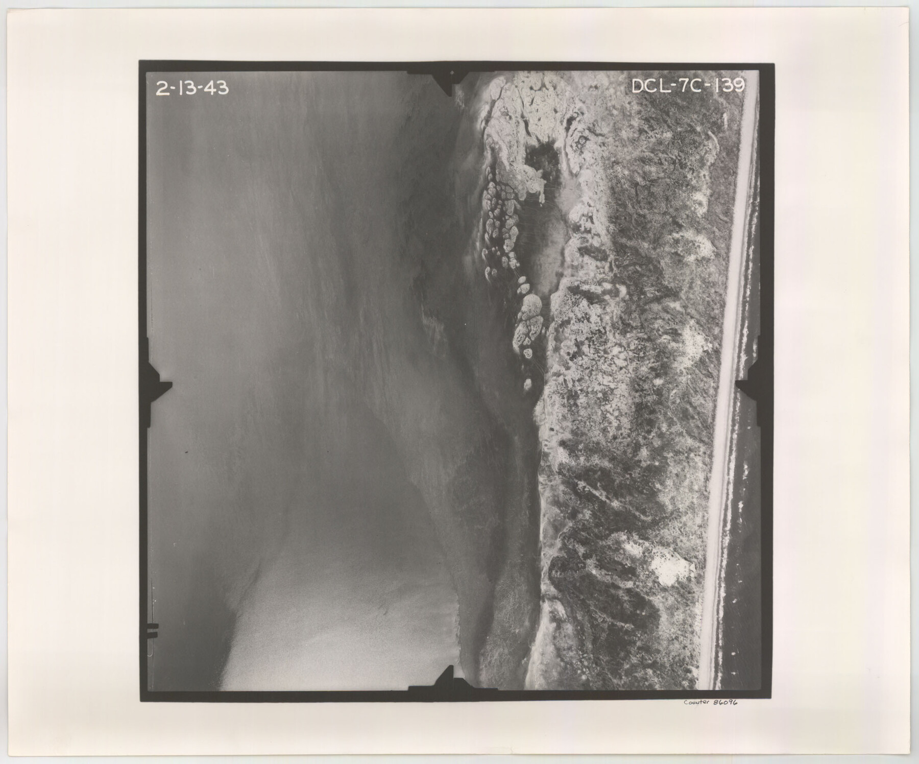
Flight Mission No. DCL-7C, Frame 139, Kenedy County
DCL-7C-139
-
Map/Doc
86096
-
Collection
General Map Collection
-
Object Dates
1943/2/13 (Creation Date)
-
People and Organizations
U. S. Department of Agriculture (Publisher)
-
Counties
Kenedy
-
Subjects
Aerial Photograph
-
Height x Width
18.5 x 22.3 inches
47.0 x 56.6 cm
-
Comments
Flown by Aerial Surveys of Pittsburgh, Inc. of Pittsburgh, Pennsylvania.
Part of: General Map Collection
Hemphill County

Print $20.00
- Digital $50.00
Hemphill County
1888
Size 23.9 x 18.3 inches
Map/Doc 3653
Gonzales County Boundary File 34 (9)

Print $18.00
- Digital $50.00
Gonzales County Boundary File 34 (9)
Size 8.5 x 3.9 inches
Map/Doc 53836
Maps of Gulf Intracoastal Waterway, Texas - Sabine River to the Rio Grande and connecting waterways including ship channels

Print $20.00
- Digital $50.00
Maps of Gulf Intracoastal Waterway, Texas - Sabine River to the Rio Grande and connecting waterways including ship channels
1966
Size 14.6 x 22.2 inches
Map/Doc 61955
Van Zandt County Working Sketch 11

Print $20.00
- Digital $50.00
Van Zandt County Working Sketch 11
1982
Size 15.2 x 9.3 inches
Map/Doc 72261
Flight Mission No. BQR-22K, Frame 46, Brazoria County

Print $20.00
- Digital $50.00
Flight Mission No. BQR-22K, Frame 46, Brazoria County
1953
Size 18.6 x 22.4 inches
Map/Doc 84130
Bosque County Sketch File 27

Print $40.00
- Digital $50.00
Bosque County Sketch File 27
Size 14.7 x 17.5 inches
Map/Doc 10937
Upton County Working Sketch 4

Print $20.00
- Digital $50.00
Upton County Working Sketch 4
Size 21.8 x 33.9 inches
Map/Doc 69500

Right of Way and Track Map, the Missouri, Kansas and Texas Ry. of Texas - Henrietta Division

Print $20.00
- Digital $50.00
Right of Way and Track Map, the Missouri, Kansas and Texas Ry. of Texas - Henrietta Division
1918
Size 11.8 x 26.8 inches
Map/Doc 64755
Jeff Davis County Rolled Sketch 17

Print $20.00
- Digital $50.00
Jeff Davis County Rolled Sketch 17
Size 28.7 x 42.2 inches
Map/Doc 6370
Sabine County Rolled Sketch 1

Print $20.00
- Digital $50.00
Sabine County Rolled Sketch 1
1958
Size 36.5 x 41.3 inches
Map/Doc 9879
Gregg County Rolled Sketch JB1
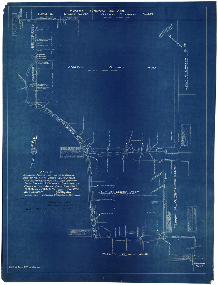
Print $20.00
- Digital $50.00
Gregg County Rolled Sketch JB1
1933
Size 43.3 x 33.4 inches
Map/Doc 9024
You may also like
Llano County Sketch File 18

Print $20.00
- Digital $50.00
Llano County Sketch File 18
1949
Size 22.3 x 20.0 inches
Map/Doc 12013
Scenes Around Carrizo Springs, Texas the Hub of the Winter Garden District

Print $20.00
- Digital $50.00
Scenes Around Carrizo Springs, Texas the Hub of the Winter Garden District
1920
Size 8.8 x 15.5 inches
Map/Doc 96767
Maps of Gulf Intracoastal Waterway, Texas - Sabine River to the Rio Grande and connecting waterways including ship channels

Print $20.00
- Digital $50.00
Maps of Gulf Intracoastal Waterway, Texas - Sabine River to the Rio Grande and connecting waterways including ship channels
1966
Size 14.5 x 22.2 inches
Map/Doc 61915
Ellis County Sketch File 3

Print $20.00
- Digital $50.00
Ellis County Sketch File 3
Size 23.6 x 28.0 inches
Map/Doc 11462
![94184, Texas [Verso], General Map Collection](https://historictexasmaps.com/wmedia_w700/maps/94184.tif.jpg)
Texas-Indian Territory Gainesville Quadrangle

Print $20.00
- Digital $50.00
Texas-Indian Territory Gainesville Quadrangle
1902
Size 20.4 x 16.9 inches
Map/Doc 75102

A Map of Lewis and Clark's Track, across the Western Portion of North America from the Mississippi to the Pacific Ocean; by order of the Executive of the United States in 1804, 5 & 6

Print $20.00
- Digital $50.00
A Map of Lewis and Clark's Track, across the Western Portion of North America from the Mississippi to the Pacific Ocean; by order of the Executive of the United States in 1804, 5 & 6
1962
Size 11.5 x 25.1 inches
Map/Doc 97174
Harris County Sketch File 15

Print $4.00
- Digital $50.00
Harris County Sketch File 15
Size 8.0 x 8.9 inches
Map/Doc 25359
Flight Mission No. CRC-4R, Frame 76, Chambers County

Print $20.00
- Digital $50.00
Flight Mission No. CRC-4R, Frame 76, Chambers County
1956
Size 18.8 x 22.4 inches
Map/Doc 84880
Coke County Rolled Sketch 9

Print $20.00
- Digital $50.00
Coke County Rolled Sketch 9
Size 25.7 x 20.7 inches
Map/Doc 5508
General Highway Map, Young County, Texas

Print $20.00
General Highway Map, Young County, Texas
1940
Size 18.4 x 24.8 inches
Map/Doc 79286