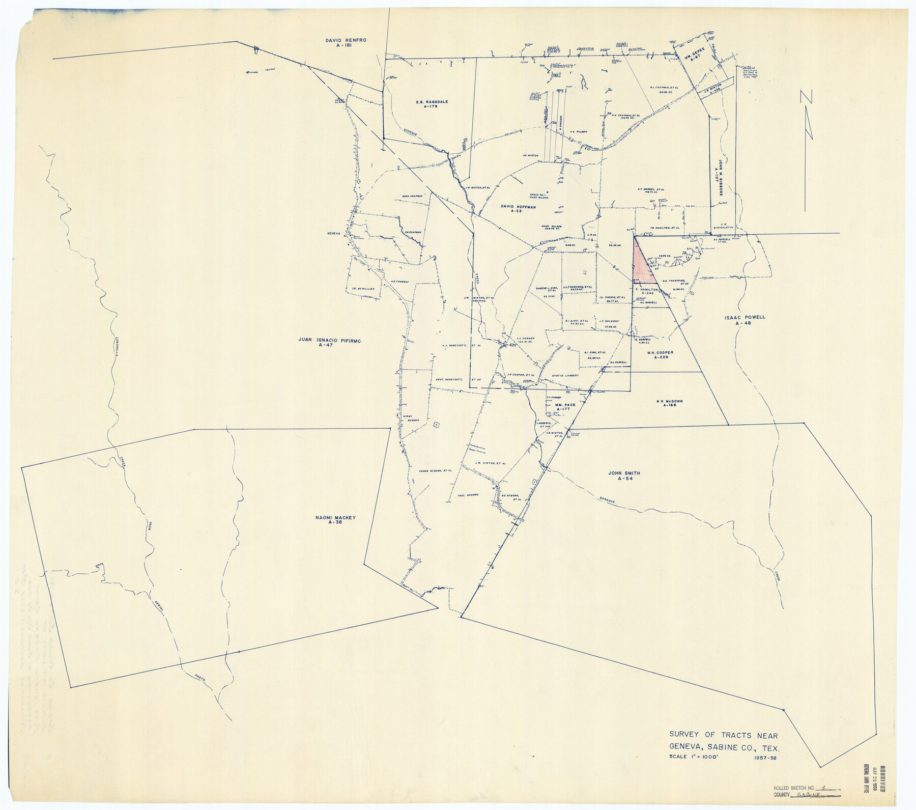
Sabine County Rolled Sketch 1
Survey of tracts near Geneva, Sabine Co., Tex.
-
Map/Doc
9879
-
Collection
General Map Collection
-
Object Dates
1958/6/12 (File Date)
1958 (Creation Date)
-
Counties
Sabine
-
Subjects
Surveying Rolled Sketch
-
Height x Width
36.5 x 41.3 inches
92.7 x 104.9 cm
-
Medium
blueprint/diazo
-
Scale
1" = 1000 feet
Part of: General Map Collection
Robertson County Working Sketch 7

Print $20.00
- Digital $50.00
Robertson County Working Sketch 7
1983
Size 36.6 x 38.3 inches
Map/Doc 78228
Duval County Sketch File 80

Print $32.00
- Digital $50.00
Duval County Sketch File 80
Size 14.1 x 8.9 inches
Map/Doc 21492
Texas Panhandle East Boundary Line

Print $20.00
- Digital $50.00
Texas Panhandle East Boundary Line
1898
Size 32.1 x 8.8 inches
Map/Doc 1700
Presidio County Working Sketch 145

Print $20.00
- Digital $50.00
Presidio County Working Sketch 145
1990
Size 29.5 x 42.7 inches
Map/Doc 71823
Harris County Working Sketch 1

Print $20.00
- Digital $50.00
Harris County Working Sketch 1
Size 15.8 x 15.8 inches
Map/Doc 65893
Connected Map of Austin's Colony

Print $20.00
- Digital $50.00
Connected Map of Austin's Colony
1892
Size 47.1 x 42.8 inches
Map/Doc 76073
Williamson County Rolled Sketch 7

Print $40.00
- Digital $50.00
Williamson County Rolled Sketch 7
1924
Size 38.4 x 54.5 inches
Map/Doc 10146
Lampasas County Working Sketch 2

Print $20.00
- Digital $50.00
Lampasas County Working Sketch 2
1936
Size 14.4 x 18.0 inches
Map/Doc 70279
Montague County Working Sketch 41

Print $40.00
- Digital $50.00
Montague County Working Sketch 41
1923
Size 43.3 x 70.1 inches
Map/Doc 65350
Gregg County Sketch File 1E

Print $4.00
- Digital $50.00
Gregg County Sketch File 1E
1849
Size 12.6 x 8.2 inches
Map/Doc 24545
Flight Mission No. BRA-16M, Frame 92, Jefferson County

Print $20.00
- Digital $50.00
Flight Mission No. BRA-16M, Frame 92, Jefferson County
1953
Size 18.6 x 22.3 inches
Map/Doc 85704
Louisiana and Texas Intracoastal Waterway, Sabine River Galveston Bay Section Survey

Print $20.00
- Digital $50.00
Louisiana and Texas Intracoastal Waterway, Sabine River Galveston Bay Section Survey
1927
Size 30.7 x 43.0 inches
Map/Doc 61838
You may also like
Flight Mission No. BRE-1P, Frame 105, Nueces County

Print $20.00
- Digital $50.00
Flight Mission No. BRE-1P, Frame 105, Nueces County
1956
Size 18.4 x 22.2 inches
Map/Doc 86676
Foard County Working Sketch 15

Print $40.00
- Digital $50.00
Foard County Working Sketch 15
1982
Size 43.7 x 76.0 inches
Map/Doc 69206
Wheeler County Working Sketch 2

Print $40.00
- Digital $50.00
Wheeler County Working Sketch 2
1957
Size 35.2 x 58.5 inches
Map/Doc 72491
Dallas County Boundary File 6a

Print $36.00
- Digital $50.00
Dallas County Boundary File 6a
Size 14.0 x 8.6 inches
Map/Doc 52189
[Motley and Foard County School Land Leagues]
![90179, [Motley and Foard County School Land Leagues], Twichell Survey Records](https://historictexasmaps.com/wmedia_w700/maps/90179-1.tif.jpg)
Print $20.00
- Digital $50.00
[Motley and Foard County School Land Leagues]
Size 22.8 x 29.6 inches
Map/Doc 90179
La Salle County Sketch File 30

Print $22.00
- Digital $50.00
La Salle County Sketch File 30
1880
Size 12.6 x 8.2 inches
Map/Doc 29565
[Plat of West Part of Section 144, Block B5]
![90602, [Plat of West Part of Section 144, Block B5], Twichell Survey Records](https://historictexasmaps.com/wmedia_w700/maps/90602-1.tif.jpg)
Print $2.00
- Digital $50.00
[Plat of West Part of Section 144, Block B5]
1931
Size 8.7 x 14.3 inches
Map/Doc 90602
Clay County Sketch File 4

Print $22.00
- Digital $50.00
Clay County Sketch File 4
1854
Size 5.0 x 7.5 inches
Map/Doc 18392
Tyler County Sketch File 9

Print $4.00
- Digital $50.00
Tyler County Sketch File 9
Size 8.6 x 6.7 inches
Map/Doc 38644
Edwards County Working Sketch 83

Print $20.00
- Digital $50.00
Edwards County Working Sketch 83
1965
Size 29.2 x 34.3 inches
Map/Doc 68959
[Right of Way & Track Map, The Texas & Pacific Ry. Co. Main Line]
![64671, [Right of Way & Track Map, The Texas & Pacific Ry. Co. Main Line], General Map Collection](https://historictexasmaps.com/wmedia_w700/maps/64671.tif.jpg)
Print $20.00
- Digital $50.00
[Right of Way & Track Map, The Texas & Pacific Ry. Co. Main Line]
Size 10.8 x 19.0 inches
Map/Doc 64671
Brewster County Working Sketch 96

Print $20.00
- Digital $50.00
Brewster County Working Sketch 96
1976
Size 29.4 x 20.3 inches
Map/Doc 67696