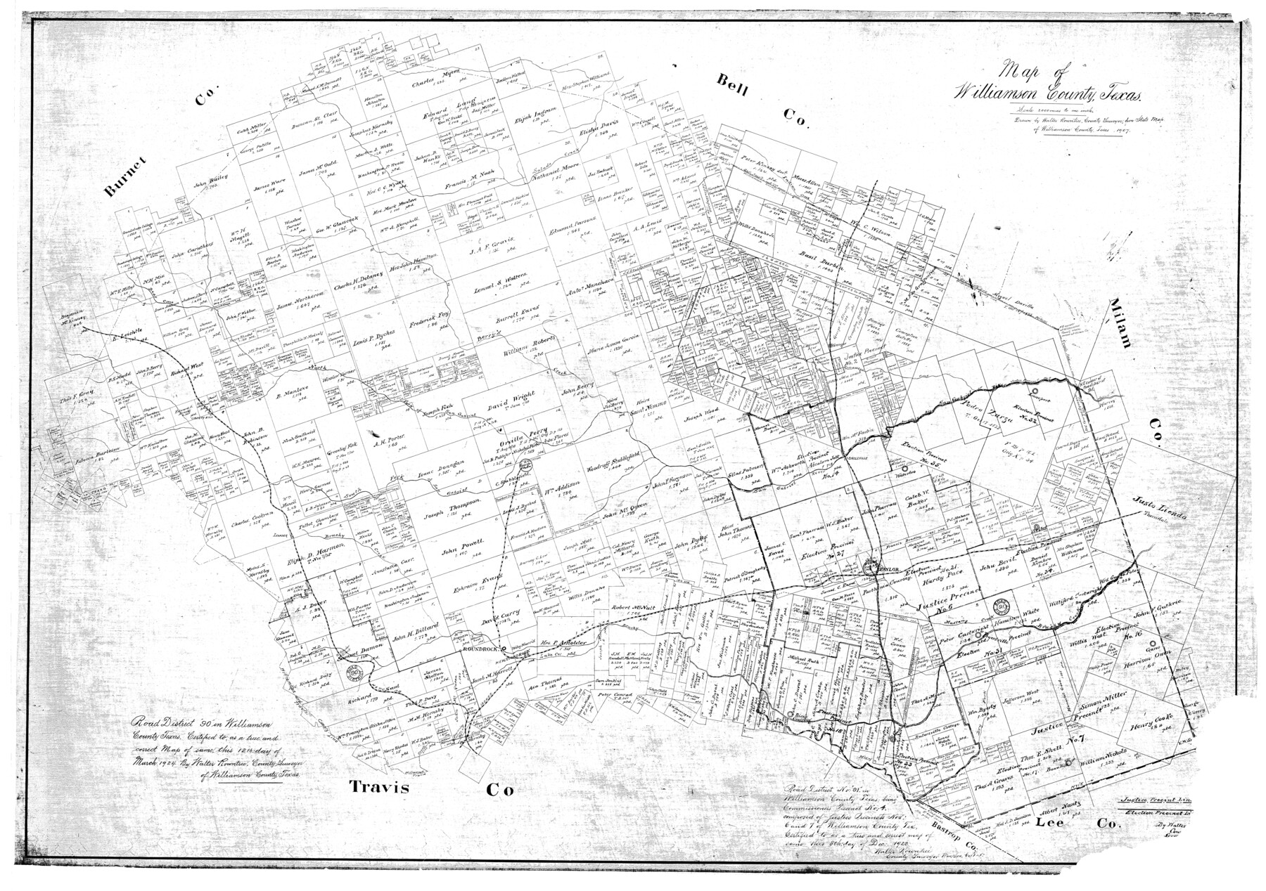
Williamson County Rolled Sketch 7
Map of Williamson County, Texas
-
Map/Doc
10146
-
Collection
General Map Collection
-
Object Dates
1924/3/12 (Creation Date)
-
People and Organizations
Walter Rountree (Draftsman)
Walter Rountree (Surveyor/Engineer)
-
Counties
Williamson
-
Subjects
Surveying Rolled Sketch
-
Height x Width
38.4 x 54.5 inches
97.5 x 138.4 cm
-
Scale
1" = 2000 varas
Part of: General Map Collection
Atascosa County Rolled Sketch 26

Print $20.00
- Digital $50.00
Atascosa County Rolled Sketch 26
2013
Size 24.6 x 36.6 inches
Map/Doc 95409
Henderson County Rolled Sketch 5

Print $40.00
- Digital $50.00
Henderson County Rolled Sketch 5
1962
Size 62.7 x 43.9 inches
Map/Doc 49660
Coke County Rolled Sketch 4

Print $20.00
- Digital $50.00
Coke County Rolled Sketch 4
Size 44.6 x 37.0 inches
Map/Doc 8624
Bell County Sketch File 19a

Print $4.00
- Digital $50.00
Bell County Sketch File 19a
Size 8.1 x 8.7 inches
Map/Doc 14404

Ellis County Sketch File 21

Print $24.00
- Digital $50.00
Ellis County Sketch File 21
1879
Size 7.6 x 12.4 inches
Map/Doc 21878
Pecos County Sketch File 38

Print $4.00
- Digital $50.00
Pecos County Sketch File 38
1895
Size 11.3 x 8.8 inches
Map/Doc 33720
Roberts County Working Sketch 5

Print $20.00
- Digital $50.00
Roberts County Working Sketch 5
1949
Size 40.4 x 40.1 inches
Map/Doc 63531
Smith County Sketch File 8

Print $4.00
- Digital $50.00
Smith County Sketch File 8
1848
Size 12.8 x 8.1 inches
Map/Doc 36761
Eastland County Working Sketch 9

Print $20.00
- Digital $50.00
Eastland County Working Sketch 9
1919
Size 33.0 x 30.6 inches
Map/Doc 68790
Calhoun County NRC Article 33.136 Sketch 3

Print $40.00
- Digital $50.00
Calhoun County NRC Article 33.136 Sketch 3
2000
Size 24.4 x 36.5 inches
Map/Doc 81914
Oldham County Sketch File 15

Print $6.00
- Digital $50.00
Oldham County Sketch File 15
1904
Size 11.2 x 8.5 inches
Map/Doc 33261
You may also like
[T. & P. Block 43, Township 1N]
![90827, [T. & P. Block 43, Township 1N], Twichell Survey Records](https://historictexasmaps.com/wmedia_w700/maps/90827-2.tif.jpg)
Print $20.00
- Digital $50.00
[T. & P. Block 43, Township 1N]
Size 23.0 x 17.8 inches
Map/Doc 90827
Refugio County Working Sketch 8

Print $40.00
- Digital $50.00
Refugio County Working Sketch 8
1940
Size 56.7 x 42.9 inches
Map/Doc 63517

Waller County Sketch File 1

Print $14.00
- Digital $50.00
Waller County Sketch File 1
Size 8.1 x 6.9 inches
Map/Doc 39563
Flight Mission No. CRK-5P, Frame 128, Refugio County

Print $20.00
- Digital $50.00
Flight Mission No. CRK-5P, Frame 128, Refugio County
1956
Size 18.6 x 22.5 inches
Map/Doc 86931
Galveston County NRC Article 33.136 Sketch 37

Print $22.00
- Digital $50.00
Galveston County NRC Article 33.136 Sketch 37
2006
Size 36.6 x 25.1 inches
Map/Doc 83551
Falls County Working Sketch Graphic Index

Print $20.00
- Digital $50.00
Falls County Working Sketch Graphic Index
1976
Size 39.7 x 44.2 inches
Map/Doc 76539
Rio Grande Rectification Project, El Paso and Juarez Valley

Print $20.00
- Digital $50.00
Rio Grande Rectification Project, El Paso and Juarez Valley
1935
Size 10.7 x 29.6 inches
Map/Doc 60866
Map of Lampasas County, Texas

Print $20.00
- Digital $50.00
Map of Lampasas County, Texas
1879
Size 23.4 x 28.4 inches
Map/Doc 560
Comal County Sketch File 1

Print $6.00
- Digital $50.00
Comal County Sketch File 1
1846
Size 16.4 x 10.5 inches
Map/Doc 18995
Edwards County Working Sketch 107

Print $40.00
- Digital $50.00
Edwards County Working Sketch 107
1972
Size 54.5 x 38.8 inches
Map/Doc 68983
Jeff Davis County Working Sketch 8

Print $20.00
- Digital $50.00
Jeff Davis County Working Sketch 8
1940
Size 45.4 x 42.9 inches
Map/Doc 66503