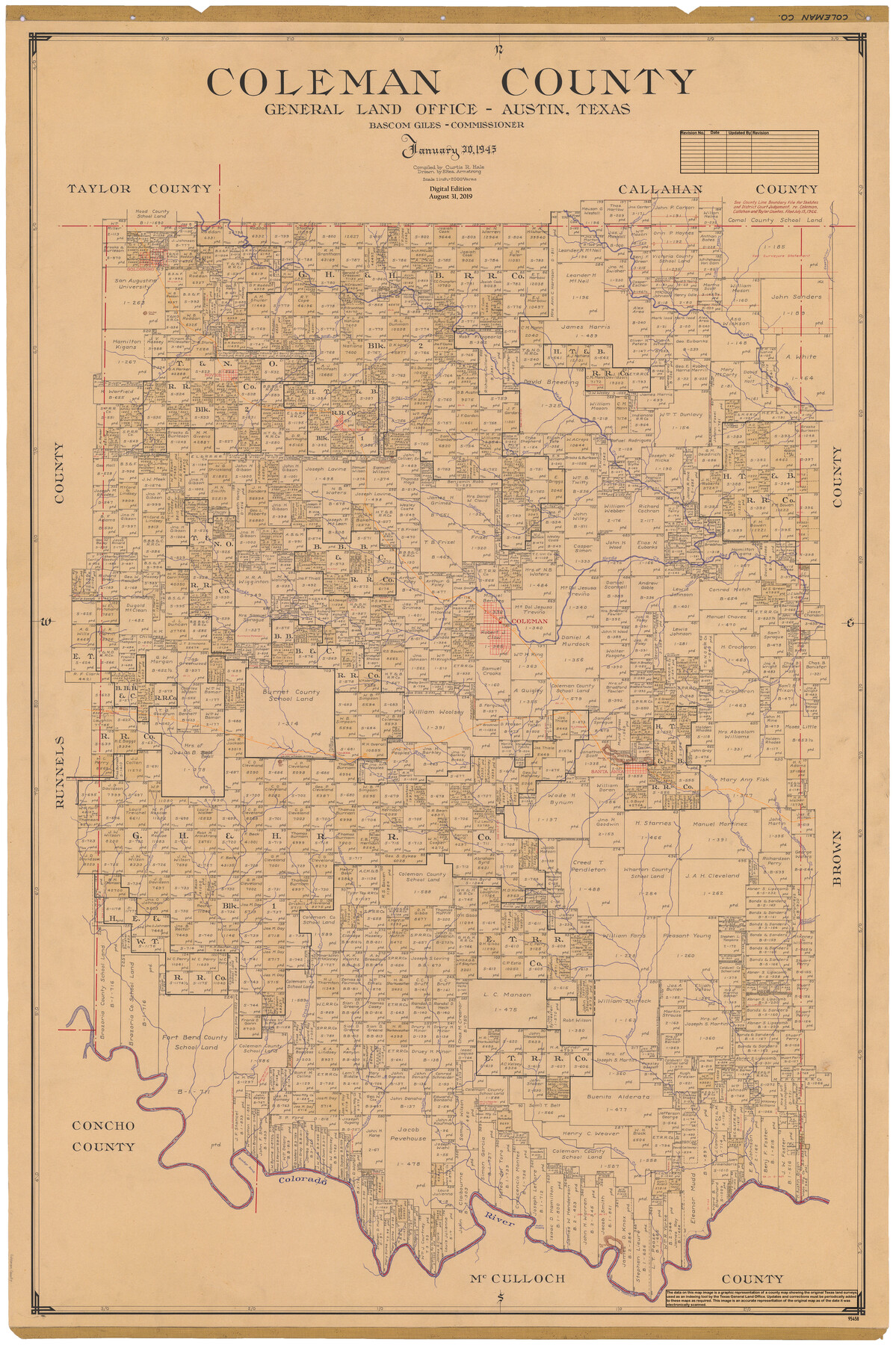
Coleman County
General Land Office Official County Map
-
Map/Doc
95458
-
Collection
General Map Collection
-
Object Dates
2019/8/31 (Revision Date)
1945/1/30 (Creation Date)
-
People and Organizations
Cheyenne Betancourt (Draftsman)
Eltea Armstrong (Draftsman)
Curtis R. Hale (Compiler)
Bascom Giles (GLO Commissioner)
-
Counties
Coleman
-
Subjects
County OCM
-
Height x Width
55.7 x 37.1 inches
141.5 x 94.2 cm
-
Medium
digital image
-
Scale
1" = 2000 varas
Part of: General Map Collection
Flight Mission No. CGI-4N, Frame 176, Cameron County

Print $20.00
- Digital $50.00
Flight Mission No. CGI-4N, Frame 176, Cameron County
1955
Size 18.5 x 22.2 inches
Map/Doc 84679
Controlled Mosaic by Jack Amman Photogrammetric Engineers, Inc - Sheet 32

Print $20.00
- Digital $50.00
Controlled Mosaic by Jack Amman Photogrammetric Engineers, Inc - Sheet 32
1954
Size 20.0 x 24.0 inches
Map/Doc 83485
Victoria County

Print $20.00
- Digital $50.00
Victoria County
1858
Size 26.5 x 29.2 inches
Map/Doc 4115
Galveston County Rolled Sketch 26

Print $950.00
- Digital $50.00
Galveston County Rolled Sketch 26
Size 10.6 x 16.1 inches
Map/Doc 44849
Maverick County Rolled Sketch 17

Print $20.00
- Digital $50.00
Maverick County Rolled Sketch 17
1910
Size 20.2 x 31.7 inches
Map/Doc 6710
Garza County Sketch File J

Print $20.00
- Digital $50.00
Garza County Sketch File J
1911
Size 26.5 x 7.5 inches
Map/Doc 11555
Wichita County Sketch File 26

Print $20.00
- Digital $50.00
Wichita County Sketch File 26
1919
Size 24.9 x 36.6 inches
Map/Doc 12686

Kimble County Working Sketch 28

Print $20.00
- Digital $50.00
Kimble County Working Sketch 28
1938
Size 29.4 x 23.2 inches
Map/Doc 70096
Flight Mission No. CRK-5P, Frame 125, Refugio County

Print $20.00
- Digital $50.00
Flight Mission No. CRK-5P, Frame 125, Refugio County
1956
Size 18.3 x 22.3 inches
Map/Doc 86928
Red River County Sketch File 6

Print $8.00
- Digital $50.00
Red River County Sketch File 6
1853
Size 10.4 x 6.9 inches
Map/Doc 35105
Blanco County Rolled Sketch 5

Print $20.00
- Digital $50.00
Blanco County Rolled Sketch 5
Size 15.6 x 17.0 inches
Map/Doc 5143
You may also like
PSL Field Notes for Block A19 in Andrews County, C45 in Andrews and Gaines Counties, C31 in Dawson and Gaines Counties, C34 in Terry and Gaines Counties, C35 in Yoakum and Gaines Counties, and Blocks C30, C32, C33, C43, and C44 in Gaines County

PSL Field Notes for Block A19 in Andrews County, C45 in Andrews and Gaines Counties, C31 in Dawson and Gaines Counties, C34 in Terry and Gaines Counties, C35 in Yoakum and Gaines Counties, and Blocks C30, C32, C33, C43, and C44 in Gaines County
Map/Doc 81643
McMullen County Working Sketch 18

Print $20.00
- Digital $50.00
McMullen County Working Sketch 18
1943
Size 17.0 x 16.6 inches
Map/Doc 70719
Walker County Working Sketch 7

Print $20.00
- Digital $50.00
Walker County Working Sketch 7
1935
Size 38.3 x 43.2 inches
Map/Doc 72287
Coryell County Sketch File 15

Print $4.00
- Digital $50.00
Coryell County Sketch File 15
1873
Size 13.0 x 8.5 inches
Map/Doc 19371
Duval County Working Sketch 16

Print $20.00
- Digital $50.00
Duval County Working Sketch 16
1939
Size 14.6 x 25.3 inches
Map/Doc 68729
County and Railroad Map of Texas

Print $20.00
- Digital $50.00
County and Railroad Map of Texas
1876
Size 17.0 x 16.0 inches
Map/Doc 93623
Flight Mission No. CRE-2R, Frame 88, Jackson County

Print $20.00
- Digital $50.00
Flight Mission No. CRE-2R, Frame 88, Jackson County
1956
Size 15.9 x 15.9 inches
Map/Doc 85360
La Salle County Working Sketch 48

Print $20.00
- Digital $50.00
La Salle County Working Sketch 48
1983
Size 26.2 x 36.0 inches
Map/Doc 70349
Galveston County NRC Article 33.136 Sketch 76

Print $26.00
- Digital $50.00
Galveston County NRC Article 33.136 Sketch 76
2014
Size 24.5 x 36.5 inches
Map/Doc 95125
Jim Hogg County Rolled Sketch 3

Print $20.00
- Digital $50.00
Jim Hogg County Rolled Sketch 3
1912
Size 28.2 x 20.2 inches
Map/Doc 6439
Pecos County Working Sketch 40

Print $20.00
- Digital $50.00
Pecos County Working Sketch 40
1941
Size 29.9 x 39.7 inches
Map/Doc 71512
Polk County Boundary File 70

Print $12.00
- Digital $50.00
Polk County Boundary File 70
Size 8.2 x 3.6 inches
Map/Doc 57930