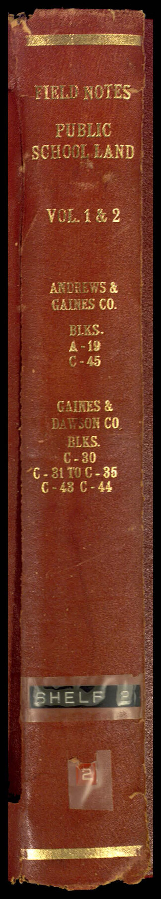
PSL Field Notes for Block A19 in Andrews County, C45 in Andrews and Gaines Counties, C31 in Dawson and Gaines Counties, C34 in Terry and Gaines Counties, C35 in Yoakum and Gaines Counties, and Blocks C30, C32, C33, C43, and C44 in Gaines County
Field Notes, Public School Land Vol. 1 and 2, Andrews and Gaines County Blocks A19, C45, Gaines and Dawson County Blocks C30, C31 to C35, C43, C44
-
Map/Doc
81643
-
Collection
General Map Collection
-
People and Organizations
Charles Rogan (GLO Commissioner)
W.D. Twichell (Surveyor/Engineer)
Robt. E. Estes (Surveyor/Engineer)
-
Counties
Terry Yoakum Gaines Dawson Andrews
-
Subjects
Bound Volume Public School Land
-
Medium
paper, bound volume
-
Comments
See 97176 for an index to the Public School Land field note volumes.
Related maps
Public School Land Field Note Volume Index

Public School Land Field Note Volume Index
2023
Size 8.5 x 11.0 inches
Map/Doc 97176
Part of: General Map Collection
Hudspeth County Rolled Sketch 63

Print $20.00
- Digital $50.00
Hudspeth County Rolled Sketch 63
Size 41.8 x 47.9 inches
Map/Doc 9227
[Edwards County]
![4939, [Edwards County], General Map Collection](https://historictexasmaps.com/wmedia_w700/maps/4939-1.tif.jpg)
Print $40.00
- Digital $50.00
[Edwards County]
1900
Size 48.6 x 32.4 inches
Map/Doc 4939
Zapata County

Print $40.00
- Digital $50.00
Zapata County
1901
Size 53.1 x 38.0 inches
Map/Doc 63143
Bowie County Sketch File 8c

Print $32.00
- Digital $50.00
Bowie County Sketch File 8c
1928
Size 8.1 x 5.3 inches
Map/Doc 14878
Winkler County Working Sketch 1

Print $20.00
- Digital $50.00
Winkler County Working Sketch 1
1944
Size 17.5 x 38.9 inches
Map/Doc 72595
Atascosa County Rolled Sketch 22

Print $40.00
- Digital $50.00
Atascosa County Rolled Sketch 22
1917
Size 57.5 x 26.5 inches
Map/Doc 8921
Polk County Sketch File 5

Print $2.00
- Digital $50.00
Polk County Sketch File 5
Size 8.0 x 7.0 inches
Map/Doc 34128
Zapata County Sketch File 16

Print $6.00
- Digital $50.00
Zapata County Sketch File 16
Size 14.5 x 8.8 inches
Map/Doc 40957
Val Verde County Sketch File Z15

Print $22.00
- Digital $50.00
Val Verde County Sketch File Z15
1902
Size 15.2 x 17.2 inches
Map/Doc 39144
Fisher County Sketch File 6

Print $6.00
- Digital $50.00
Fisher County Sketch File 6
Size 9.7 x 15.9 inches
Map/Doc 22563
Flight Mission No. BQR-12K, Frame 48, Brazoria County

Print $20.00
- Digital $50.00
Flight Mission No. BQR-12K, Frame 48, Brazoria County
1952
Size 19.0 x 22.7 inches
Map/Doc 84063
Flight Mission No. DQN-5K, Frame 39, Calhoun County

Print $20.00
- Digital $50.00
Flight Mission No. DQN-5K, Frame 39, Calhoun County
1953
Size 18.5 x 22.1 inches
Map/Doc 84387
You may also like
Bastrop County Working Sketch 11

Print $20.00
- Digital $50.00
Bastrop County Working Sketch 11
1968
Size 31.2 x 25.1 inches
Map/Doc 67311
New Map of Texas with the Contiguous American and Mexican States
Print $20.00
- Digital $50.00
New Map of Texas with the Contiguous American and Mexican States
1836
Size 13.7 x 19.7 inches
Map/Doc 76795
Motley County Sketch File 6 (N)

Print $20.00
- Digital $50.00
Motley County Sketch File 6 (N)
1900
Size 14.0 x 8.6 inches
Map/Doc 32004
Flight Mission No. BQR-20K, Frame 10, Brazoria County

Print $20.00
- Digital $50.00
Flight Mission No. BQR-20K, Frame 10, Brazoria County
1952
Size 18.6 x 22.3 inches
Map/Doc 84112
Webb County Sketch File 11a-1

Print $27.00
- Digital $50.00
Webb County Sketch File 11a-1
1884
Size 22.2 x 9.3 inches
Map/Doc 12626
Martin County Working Sketch 15

Print $20.00
- Digital $50.00
Martin County Working Sketch 15
1975
Size 23.9 x 19.5 inches
Map/Doc 70833
General Highway Map, Jim Hogg County, Texas

Print $20.00
General Highway Map, Jim Hogg County, Texas
1961
Size 24.6 x 18.2 inches
Map/Doc 79541
Map of Wharton County

Print $40.00
- Digital $50.00
Map of Wharton County
1895
Size 48.2 x 53.8 inches
Map/Doc 82055
Right of Way and Track Map of The Missouri, Kansas & Texas Railway of Texas

Print $40.00
- Digital $50.00
Right of Way and Track Map of The Missouri, Kansas & Texas Railway of Texas
1918
Size 24.4 x 50.7 inches
Map/Doc 64538
Presidio County Rolled Sketch 137

Print $20.00
- Digital $50.00
Presidio County Rolled Sketch 137
1999
Size 38.7 x 47.9 inches
Map/Doc 8352
Hamilton County Working Sketch 15

Print $40.00
- Digital $50.00
Hamilton County Working Sketch 15
1949
Size 54.5 x 37.6 inches
Map/Doc 63353
Bird's Eye View of San Marcos, Hays County, Texas

Print $20.00
Bird's Eye View of San Marcos, Hays County, Texas
1881
Size 18.5 x 28.3 inches
Map/Doc 89205