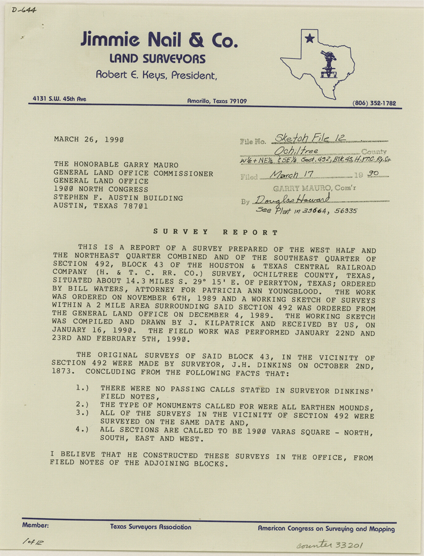
Ochiltree County Sketch File 12
[Report and photos regarding section 492, Block 43, H. & T. C. R.R. Co.]
-
Map/Doc
33201
-
Collection
General Map Collection
-
Object Dates
3/26/1990 (Creation Date)
3/17/1990 (File Date)
1/22/1990, 1/23/1990, & 2/5/1990 (Survey Date)
-
People and Organizations
Jimmie Nail (Surveyor/Engineer)
-
Counties
Ochiltree
-
Subjects
Surveying Sketch File
-
Height x Width
11.2 x 8.5 inches
28.5 x 21.6 cm
-
Medium
multi-page, multi-format
-
Features
Northup Creek
Part of: General Map Collection
Brewster County Sketch File D-1

Print $12.00
- Digital $50.00
Brewster County Sketch File D-1
1909
Size 14.4 x 8.8 inches
Map/Doc 15740
Right of Way and Track Map, The Wichita Falls & Southern Railway

Print $40.00
- Digital $50.00
Right of Way and Track Map, The Wichita Falls & Southern Railway
1942
Size 25.5 x 92.5 inches
Map/Doc 64513
Mason County Working Sketch 8

Print $20.00
- Digital $50.00
Mason County Working Sketch 8
1946
Size 22.9 x 32.3 inches
Map/Doc 70844
Childress County Rolled Sketch 9

Print $20.00
- Digital $50.00
Childress County Rolled Sketch 9
Size 19.3 x 22.9 inches
Map/Doc 5446
Flight Mission No. DQN-2K, Frame 119, Calhoun County

Print $20.00
- Digital $50.00
Flight Mission No. DQN-2K, Frame 119, Calhoun County
1953
Size 16.8 x 16.5 inches
Map/Doc 84295
Nueces County Sketch File 73

Print $4.00
- Digital $50.00
Nueces County Sketch File 73
1991
Size 11.1 x 8.8 inches
Map/Doc 33026
Flight Mission No. BRA-16M, Frame 124, Jefferson County

Print $20.00
- Digital $50.00
Flight Mission No. BRA-16M, Frame 124, Jefferson County
1953
Size 18.7 x 22.5 inches
Map/Doc 85734
Concho County Working Sketch 18

Print $20.00
- Digital $50.00
Concho County Working Sketch 18
1957
Size 19.2 x 25.2 inches
Map/Doc 68200
Andrews County Working Sketch 32

Print $20.00
- Digital $50.00
Andrews County Working Sketch 32
1990
Size 29.6 x 31.5 inches
Map/Doc 67078
Upton County Rolled Sketch 20

Print $40.00
- Digital $50.00
Upton County Rolled Sketch 20
1933
Size 53.0 x 36.8 inches
Map/Doc 10041
Travis County Sketch File 35

Print $2.00
- Digital $50.00
Travis County Sketch File 35
Size 10.8 x 8.3 inches
Map/Doc 38354
Morris County Rolled Sketch 2A

Print $20.00
- Digital $50.00
Morris County Rolled Sketch 2A
Size 24.0 x 18.6 inches
Map/Doc 10235
You may also like
Foard County Sketch File 28

Print $20.00
- Digital $50.00
Foard County Sketch File 28
1883
Size 34.7 x 38.0 inches
Map/Doc 10452
Hamilton County

Print $20.00
- Digital $50.00
Hamilton County
1916
Size 41.4 x 40.5 inches
Map/Doc 66851
San Augustine County Working Sketch 23

Print $20.00
- Digital $50.00
San Augustine County Working Sketch 23
1974
Size 23.6 x 36.4 inches
Map/Doc 63711
Goliad Station Map, Galveston, Harrisburg & San Antonio Ry. operated by the T. & N. O. R.R. Co.

Print $40.00
- Digital $50.00
Goliad Station Map, Galveston, Harrisburg & San Antonio Ry. operated by the T. & N. O. R.R. Co.
1918
Size 24.7 x 55.8 inches
Map/Doc 76161
Sketch in Martin County Showing Survey 13, Block X

Print $2.00
- Digital $50.00
Sketch in Martin County Showing Survey 13, Block X
1908
Size 12.6 x 8.4 inches
Map/Doc 91286
Map of George W. Littlefield's Ranch Located on State Capitol Leagues 657- 736 Situated in Lamb and Hockley Counties

Print $2.00
- Digital $50.00
Map of George W. Littlefield's Ranch Located on State Capitol Leagues 657- 736 Situated in Lamb and Hockley Counties
Size 6.3 x 8.2 inches
Map/Doc 91121
Lubbock County Boundary File 8

Print $46.00
- Digital $50.00
Lubbock County Boundary File 8
Size 7.3 x 8.7 inches
Map/Doc 56525
Flight Mission No. BRE-1P, Frame 30, Nueces County

Print $20.00
- Digital $50.00
Flight Mission No. BRE-1P, Frame 30, Nueces County
1956
Size 18.4 x 22.3 inches
Map/Doc 86626
Florida called by ye French Louisiana & c.

Print $20.00
- Digital $50.00
Florida called by ye French Louisiana & c.
1728
Size 9.6 x 14.3 inches
Map/Doc 94110
Brewster County Working Sketch 107

Print $20.00
- Digital $50.00
Brewster County Working Sketch 107
1981
Size 34.7 x 37.1 inches
Map/Doc 67707
Waco Village, County Seat of McLennan County

Print $20.00
Waco Village, County Seat of McLennan County
1850
Size 15.8 x 12.4 inches
Map/Doc 76268
