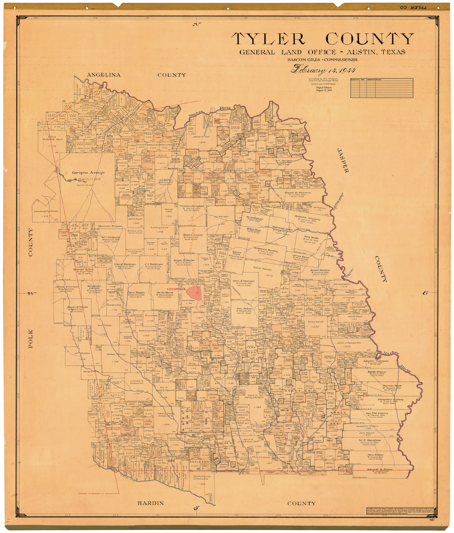
Tyler County
General Land Office Official County Map
-
Map/Doc
95657
-
Collection
General Map Collection
-
Object Dates
2/14/1944 (Creation Date)
8/31/2019 (Revision Date)
-
People and Organizations
Bascom Giles (GLO Commissioner)
R.C. Wisdom (Compiler)
Tommye Buie (Draftsman)
Cheyenne Betancourt (Draftsman)
-
Counties
Tyler
-
Subjects
County OCM
-
Height x Width
48.9 x 41.6 inches
124.2 x 105.7 cm
-
Medium
digital image
-
Scale
1" = 2000 varas
Part of: General Map Collection
Brewster County Rolled Sketch 114

Print $20.00
- Digital $50.00
Brewster County Rolled Sketch 114
1964
Size 11.6 x 18.5 inches
Map/Doc 5275
Schleicher County Working Sketch 15

Print $20.00
- Digital $50.00
Schleicher County Working Sketch 15
1940
Size 30.1 x 33.6 inches
Map/Doc 63817
Map of Ellis County

Print $20.00
- Digital $50.00
Map of Ellis County
1889
Size 38.9 x 47.7 inches
Map/Doc 4941
Flight Mission No. DQO-1K, Frame 21, Galveston County

Print $20.00
- Digital $50.00
Flight Mission No. DQO-1K, Frame 21, Galveston County
1952
Size 18.8 x 22.6 inches
Map/Doc 84980
Flight Mission No. DQN-1K, Frame 143, Calhoun County

Print $20.00
- Digital $50.00
Flight Mission No. DQN-1K, Frame 143, Calhoun County
1953
Size 18.5 x 22.1 inches
Map/Doc 84206
Crosby County Sketch File 11a

Print $10.00
- Digital $50.00
Crosby County Sketch File 11a
1894
Size 8.7 x 4.4 inches
Map/Doc 20029
Webb County Working Sketch 11

Print $20.00
- Digital $50.00
Webb County Working Sketch 11
1921
Size 17.8 x 16.3 inches
Map/Doc 72376

Map of Fort Bend County

Print $20.00
- Digital $50.00
Map of Fort Bend County
1839
Size 19.0 x 26.9 inches
Map/Doc 3549
Flight Mission No. DIX-3P, Frame 166, Aransas County

Print $20.00
- Digital $50.00
Flight Mission No. DIX-3P, Frame 166, Aransas County
1956
Size 17.8 x 18.7 inches
Map/Doc 83772
Texas Coordinate File 6

Print $40.00
- Digital $50.00
Texas Coordinate File 6
1946
Size 23.7 x 49.0 inches
Map/Doc 75314
Flight Mission No. DQN-7K, Frame 15, Calhoun County

Print $20.00
- Digital $50.00
Flight Mission No. DQN-7K, Frame 15, Calhoun County
1953
Size 18.4 x 22.1 inches
Map/Doc 84466
You may also like
Roberts County

Print $20.00
- Digital $50.00
Roberts County
1878
Size 20.1 x 18.0 inches
Map/Doc 3991
Callahan County Boundary File 1

Print $120.00
- Digital $50.00
Callahan County Boundary File 1
Size 14.2 x 8.6 inches
Map/Doc 51025
Map of the Globe showing its continents, islands, mountain ranges, table lands, plains and slopes

Print $20.00
- Digital $50.00
Map of the Globe showing its continents, islands, mountain ranges, table lands, plains and slopes
1885
Size 12.2 x 18.5 inches
Map/Doc 93532
Moore County Working Sketch 1

Print $20.00
- Digital $50.00
Moore County Working Sketch 1
1909
Size 32.0 x 32.4 inches
Map/Doc 71183
Freestone County Rolled Sketch 13A

Print $20.00
- Digital $50.00
Freestone County Rolled Sketch 13A
1990
Size 45.2 x 33.7 inches
Map/Doc 5914
Van Zandt County Sketch File 17 and 17a

Print $6.00
- Digital $50.00
Van Zandt County Sketch File 17 and 17a
1858
Size 14.2 x 8.1 inches
Map/Doc 39417
Hardin County Rolled Sketch 5

Print $20.00
- Digital $50.00
Hardin County Rolled Sketch 5
1937
Size 21.5 x 18.8 inches
Map/Doc 6078
Crosby County Working Sketch 1

Print $20.00
- Digital $50.00
Crosby County Working Sketch 1
Size 28.0 x 26.0 inches
Map/Doc 68435
Val Verde County Sketch File C

Print $62.00
- Digital $50.00
Val Verde County Sketch File C
1898
Size 15.5 x 19.8 inches
Map/Doc 12545
Dawson County Working Sketch 19

Print $20.00
- Digital $50.00
Dawson County Working Sketch 19
1963
Size 24.8 x 32.4 inches
Map/Doc 68563
Preliminary map of Brazos Island

Print $20.00
- Digital $50.00
Preliminary map of Brazos Island
1863
Size 25.2 x 18.1 inches
Map/Doc 72924
Flight Mission No. BRE-2P, Frame 72, Nueces County

Print $20.00
- Digital $50.00
Flight Mission No. BRE-2P, Frame 72, Nueces County
1956
Size 18.5 x 22.2 inches
Map/Doc 86767