Texas Coordinate File 6
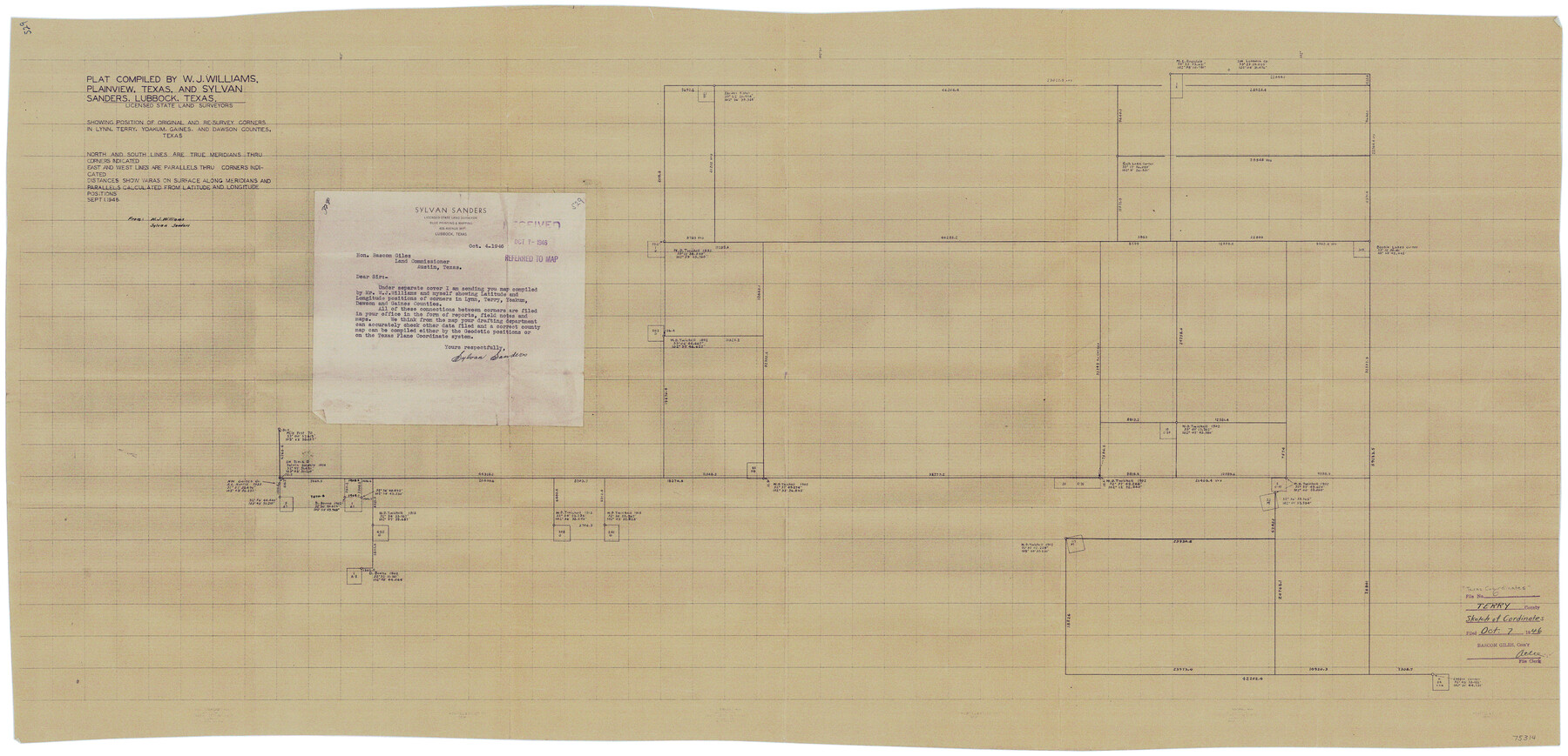
[Plat showing latitude and longitude positions of recognized corners in Lynn, Terry, Yoakum, Gaines and Dawson Counties]
-
Map/Doc
75314
-
Collection
General Map Collection
-
Object Dates
9/1/1946 (Creation Date)
-
Counties
Lynn Terry Yoakum Dawson Gaines
-
Subjects
Coordinates
-
Height x Width
23.7 x 49.0 inches
60.2 x 124.5 cm
Part of: General Map Collection
Webb County Working Sketch 10

Print $20.00
- Digital $50.00
Webb County Working Sketch 10
1913
Size 23.7 x 20.0 inches
Map/Doc 72375
Intracoastal Waterway in Texas - Corpus Christi to Point Isabel including Arroyo Colorado to Mo. Pac. R.R. Bridge Near Harlingen

Print $20.00
- Digital $50.00
Intracoastal Waterway in Texas - Corpus Christi to Point Isabel including Arroyo Colorado to Mo. Pac. R.R. Bridge Near Harlingen
1933
Size 28.1 x 40.8 inches
Map/Doc 61876
Rio Grande, Raymondville Sheet

Print $20.00
- Digital $50.00
Rio Grande, Raymondville Sheet
1925
Size 43.7 x 17.8 inches
Map/Doc 65127
Comal County Sketch File 3b

Print $20.00
- Digital $50.00
Comal County Sketch File 3b
1847
Size 12.4 x 16.1 inches
Map/Doc 19003
Map from Corpus Christi to Matagorda Bays, Texas [Inset: Survey of the channel of Copono Bay]
![72976, Map from Corpus Christi to Matagorda Bays, Texas [Inset: Survey of the channel of Copono Bay], General Map Collection](https://historictexasmaps.com/wmedia_w700/maps/72976.tif.jpg)
Print $20.00
- Digital $50.00
Map from Corpus Christi to Matagorda Bays, Texas [Inset: Survey of the channel of Copono Bay]
1846
Size 18.1 x 27.5 inches
Map/Doc 72976
Edwards County Working Sketch 72

Print $20.00
- Digital $50.00
Edwards County Working Sketch 72
1957
Size 21.0 x 22.1 inches
Map/Doc 68948

Mason County Sketch File 19

Print $20.00
- Digital $50.00
Mason County Sketch File 19
1901
Size 19.1 x 20.9 inches
Map/Doc 12036
Newton County Working Sketch 41

Print $20.00
- Digital $50.00
Newton County Working Sketch 41
1979
Size 17.8 x 26.2 inches
Map/Doc 71287
Louisiana and Texas Intracoastal Waterway - Sabine River-Galveston Bay Section, Steel Sheet Pile Dyke at Galveston Bay Entrance

Print $20.00
- Digital $50.00
Louisiana and Texas Intracoastal Waterway - Sabine River-Galveston Bay Section, Steel Sheet Pile Dyke at Galveston Bay Entrance
1933
Size 31.4 x 40.9 inches
Map/Doc 61818
Presidio County Rolled Sketch 82

Print $20.00
- Digital $50.00
Presidio County Rolled Sketch 82
1943
Size 35.5 x 26.1 inches
Map/Doc 7369
Flight Mission No. BRA-7M, Frame 35, Jefferson County

Print $20.00
- Digital $50.00
Flight Mission No. BRA-7M, Frame 35, Jefferson County
1953
Size 18.7 x 22.4 inches
Map/Doc 85486
You may also like
University Land in Hudspeth County showing Mineral Surveys in Blocks A, B, C, D, E, F, G, H, I, J, K, L, M, N

Print $40.00
- Digital $50.00
University Land in Hudspeth County showing Mineral Surveys in Blocks A, B, C, D, E, F, G, H, I, J, K, L, M, N
Size 39.7 x 48.4 inches
Map/Doc 2421
Martin County Rolled Sketch 7

Print $20.00
- Digital $50.00
Martin County Rolled Sketch 7
1929
Size 23.0 x 31.2 inches
Map/Doc 6667
Map of Garza County, Texas

Print $20.00
- Digital $50.00
Map of Garza County, Texas
1936
Size 28.7 x 36.3 inches
Map/Doc 92648
Baylor County Sketch File 12E

Print $11.00
- Digital $50.00
Baylor County Sketch File 12E
1900
Size 14.3 x 8.8 inches
Map/Doc 14159
Flight Mission No. BRA-16M, Frame 66, Jefferson County

Print $20.00
- Digital $50.00
Flight Mission No. BRA-16M, Frame 66, Jefferson County
1953
Size 18.6 x 22.3 inches
Map/Doc 85683
[Pencil sketch of surveys 820-831 along river]
![91983, [Pencil sketch of surveys 820-831 along river], Twichell Survey Records](https://historictexasmaps.com/wmedia_w700/maps/91983-1.tif.jpg)
Print $20.00
- Digital $50.00
[Pencil sketch of surveys 820-831 along river]
Size 23.0 x 10.3 inches
Map/Doc 91983
Treaty to Resolve Pending Boundary Differences and Maintain the Rio Grande and Colorado River as the International Boundary Between the United States of American and Mexico

Print $4.00
- Digital $50.00
Treaty to Resolve Pending Boundary Differences and Maintain the Rio Grande and Colorado River as the International Boundary Between the United States of American and Mexico
1970
Size 12.1 x 19.0 inches
Map/Doc 83099
[J. Sherwood and surrounding surveys]
![90977, [J. Sherwood and surrounding surveys], Twichell Survey Records](https://historictexasmaps.com/wmedia_w700/maps/90977-1.tif.jpg)
Print $20.00
- Digital $50.00
[J. Sherwood and surrounding surveys]
Size 24.2 x 18.1 inches
Map/Doc 90977
Terrell County Working Sketch 5

Print $20.00
- Digital $50.00
Terrell County Working Sketch 5
1914
Size 32.0 x 26.3 inches
Map/Doc 62154
Map of the United States to accompany Granger's Southern and Western Texas Guide

Print $20.00
- Digital $50.00
Map of the United States to accompany Granger's Southern and Western Texas Guide
1878
Size 26.7 x 20.9 inches
Map/Doc 96613
Jasper County Sketch File 32

Print $20.00
- Digital $50.00
Jasper County Sketch File 32
1906
Size 28.0 x 22.3 inches
Map/Doc 11853
Hardeman County Aerial Photograph Index Sheet 2

Print $20.00
- Digital $50.00
Hardeman County Aerial Photograph Index Sheet 2
1950
Size 20.3 x 16.9 inches
Map/Doc 83698