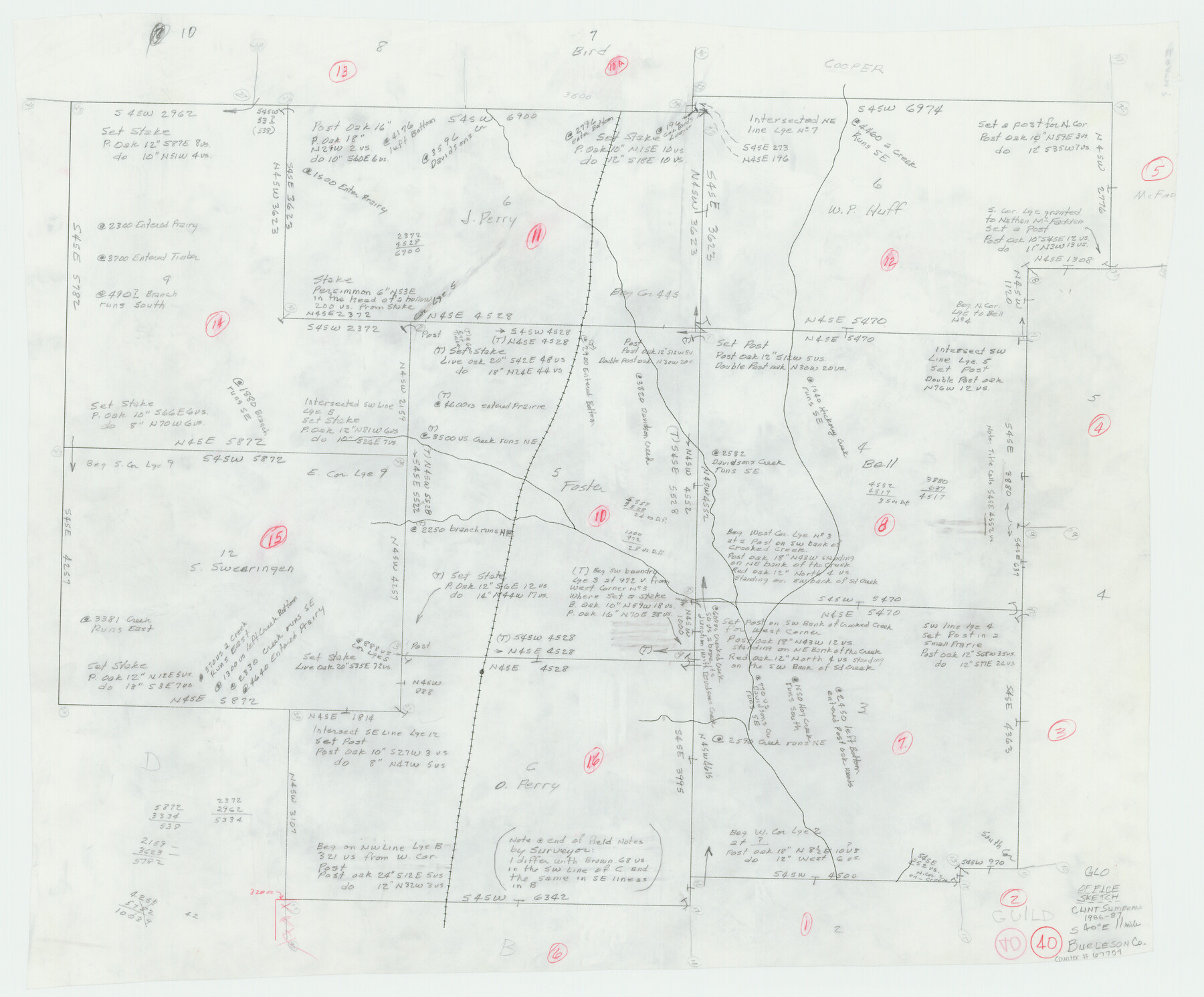
Burleson County Working Sketch 40
-
Map/Doc
67759
-
Collection
General Map Collection
-
Object Dates
1986-1987 (Creation Date)
-
People and Organizations
Clinton H. Sumrall (Surveyor/Engineer)
-
Counties
Burleson
-
Subjects
Surveying Working Sketch
-
Height x Width
23.1 x 27.9 inches
58.7 x 70.9 cm
Part of: General Map Collection
Carson County Rolled Sketch 1

Print $20.00
- Digital $50.00
Carson County Rolled Sketch 1
Size 31.2 x 33.4 inches
Map/Doc 8580
PSL Field Notes for Blocks 1 and 2, Hansford and Sherman Counties, Blocks 3 and 4, Hansford County, Blocks A1, A2, A4, A5, and A6 in Hartley County, Block C0 in Hockley, Lubbock, Lynn, and Terry Counties, and Blocks A and B in Kent County

PSL Field Notes for Blocks 1 and 2, Hansford and Sherman Counties, Blocks 3 and 4, Hansford County, Blocks A1, A2, A4, A5, and A6 in Hartley County, Block C0 in Hockley, Lubbock, Lynn, and Terry Counties, and Blocks A and B in Kent County
Map/Doc 81655
Harrison County Working Sketch 34

Print $20.00
- Digital $50.00
Harrison County Working Sketch 34
2015
Size 13.7 x 17.9 inches
Map/Doc 93726
Hockley County

Print $20.00
- Digital $50.00
Hockley County
1954
Size 42.9 x 38.9 inches
Map/Doc 1856
[Sketch for Mineral Application 19144 - Pecos River Bed]
![65573, [Sketch for Mineral Application 19144 - Pecos River Bed], General Map Collection](https://historictexasmaps.com/wmedia_w700/maps/65573.tif.jpg)
Print $20.00
- Digital $50.00
[Sketch for Mineral Application 19144 - Pecos River Bed]
1927
Size 45.2 x 46.4 inches
Map/Doc 65573
Rockport Quadrangle

Print $20.00
- Digital $50.00
Rockport Quadrangle
1954
Size 21.3 x 18.3 inches
Map/Doc 73435
Nueces County NRC Article 33.136 Sketch 22

Print $42.00
Nueces County NRC Article 33.136 Sketch 22
2023
Map/Doc 97180
Val Verde County Sketch File 15a

Print $40.00
- Digital $50.00
Val Verde County Sketch File 15a
1885
Size 15.8 x 12.7 inches
Map/Doc 39217
El Paso County Working Sketch 4

Print $20.00
- Digital $50.00
El Paso County Working Sketch 4
1916
Size 21.4 x 37.3 inches
Map/Doc 69026
Map of the Houston Ship Channel showing all industries, railways, public and private docks, and approximate all original surveys in the vicinity of the channel

Print $20.00
- Digital $50.00
Map of the Houston Ship Channel showing all industries, railways, public and private docks, and approximate all original surveys in the vicinity of the channel
1925
Size 14.5 x 30.2 inches
Map/Doc 4666
Flight Mission No. CRK-3P, Frame 61, Refugio County

Print $20.00
- Digital $50.00
Flight Mission No. CRK-3P, Frame 61, Refugio County
1956
Size 18.7 x 22.5 inches
Map/Doc 86903
Flight Mission No. CGI-4N, Frame 25, Cameron County

Print $20.00
- Digital $50.00
Flight Mission No. CGI-4N, Frame 25, Cameron County
1954
Size 18.7 x 22.4 inches
Map/Doc 84658
You may also like
Flight Mission No. CRC-1R, Frame 35, Chambers County

Print $20.00
- Digital $50.00
Flight Mission No. CRC-1R, Frame 35, Chambers County
1956
Size 18.9 x 22.5 inches
Map/Doc 84703
Culberson County Working Sketch 16

Print $20.00
- Digital $50.00
Culberson County Working Sketch 16
1926
Size 17.5 x 23.4 inches
Map/Doc 68468
Cass County Working Sketch 4

Print $20.00
- Digital $50.00
Cass County Working Sketch 4
1936
Size 33.7 x 29.1 inches
Map/Doc 67907
Montague County Rolled Sketch 7

Print $20.00
- Digital $50.00
Montague County Rolled Sketch 7
1964
Size 17.8 x 22.9 inches
Map/Doc 6791
Nueces County Rolled Sketch 127

Print $20.00
- Digital $50.00
Nueces County Rolled Sketch 127
1998
Size 24.1 x 36.4 inches
Map/Doc 7162
Titus County Sketch File 14

Print $4.00
- Digital $50.00
Titus County Sketch File 14
Size 9.7 x 8.3 inches
Map/Doc 38157
Upshur County Working Sketch 14

Print $20.00
- Digital $50.00
Upshur County Working Sketch 14
1993
Size 23.1 x 37.1 inches
Map/Doc 69571
Nueces County Rolled Sketch 111

Print $20.00
- Digital $50.00
Nueces County Rolled Sketch 111
1991
Size 24.6 x 36.1 inches
Map/Doc 7119
Oldham County

Print $40.00
- Digital $50.00
Oldham County
1925
Size 43.6 x 53.5 inches
Map/Doc 66960
Myrick Farm Lubbock & Hockley Counties

Print $20.00
- Digital $50.00
Myrick Farm Lubbock & Hockley Counties
Size 21.1 x 18.8 inches
Map/Doc 92831
Colorado County Sketch File 30

Print $14.00
- Digital $50.00
Colorado County Sketch File 30
1943
Size 14.1 x 8.6 inches
Map/Doc 18977
Flight Mission No. BQR-5K, Frame 70, Brazoria County

Print $20.00
- Digital $50.00
Flight Mission No. BQR-5K, Frame 70, Brazoria County
1952
Size 18.8 x 22.4 inches
Map/Doc 84015