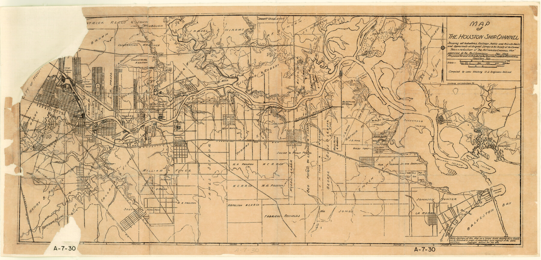
Map of the Houston Ship Channel showing all industries, railways, public and private docks, and approximate all original surveys in the vicinity of the channel
A-7-30
-
Map/Doc
4666
-
Collection
General Map Collection
-
Object Dates
1925 (Creation Date)
-
People and Organizations
Houston Chamber of Commerce (Publisher)
Louis Ginsburg (Compiler)
-
Counties
Harris Chambers
-
Subjects
Nautical Charts
-
Height x Width
14.5 x 30.2 inches
36.8 x 76.7 cm
-
Comments
This is a reduction of "The Authorized Channel Map" approved by the Port Commission, November 1925.
Part of: General Map Collection
Tom Green County Rolled Sketch 17

Print $40.00
- Digital $50.00
Tom Green County Rolled Sketch 17
Size 49.2 x 37.8 inches
Map/Doc 10005
La Salle County Working Sketch Graphic Index

Print $40.00
- Digital $50.00
La Salle County Working Sketch Graphic Index
1923
Size 48.2 x 42.0 inches
Map/Doc 76615
Jeff Davis County Sketch File 22

Print $20.00
- Digital $50.00
Jeff Davis County Sketch File 22
1923
Size 19.4 x 25.0 inches
Map/Doc 11860
Cooke County Working Sketch 30

Print $20.00
- Digital $50.00
Cooke County Working Sketch 30
1979
Size 26.6 x 28.4 inches
Map/Doc 68267
Hale County Sketch File 26

Print $40.00
- Digital $50.00
Hale County Sketch File 26
1911
Size 20.7 x 54.4 inches
Map/Doc 10471
Flight Mission No. CUG-2P, Frame 7, Kleberg County

Print $20.00
- Digital $50.00
Flight Mission No. CUG-2P, Frame 7, Kleberg County
1956
Size 18.5 x 22.3 inches
Map/Doc 86179
Kendall County Working Sketch 9

Print $40.00
- Digital $50.00
Kendall County Working Sketch 9
1953
Size 52.8 x 37.2 inches
Map/Doc 66681
Trinity County Sketch File 17

Print $4.00
- Digital $50.00
Trinity County Sketch File 17
Size 8.0 x 7.4 inches
Map/Doc 38546
Blanco County Sketch File 43

Print $6.00
- Digital $50.00
Blanco County Sketch File 43
1901
Size 9.7 x 6.2 inches
Map/Doc 14666
Zavala County Sketch File A1

Print $31.00
- Digital $50.00
Zavala County Sketch File A1
1899
Size 23.5 x 28.6 inches
Map/Doc 12735
Stonewall County Boundary File 1

Print $34.00
- Digital $50.00
Stonewall County Boundary File 1
Size 9.0 x 8.4 inches
Map/Doc 58938
Flight Mission No. CGI-3N, Frame 158, Cameron County

Print $20.00
- Digital $50.00
Flight Mission No. CGI-3N, Frame 158, Cameron County
1954
Size 18.5 x 22.4 inches
Map/Doc 84622
You may also like
United States - Gulf Coast Texas - Southern part of Laguna Madre

Print $20.00
- Digital $50.00
United States - Gulf Coast Texas - Southern part of Laguna Madre
1941
Size 18.2 x 27.7 inches
Map/Doc 72947
Map and Field Notes of D. & N. T. RR. Through E. L. Ellwood's Pasture

Print $20.00
- Digital $50.00
Map and Field Notes of D. & N. T. RR. Through E. L. Ellwood's Pasture
1912
Size 39.5 x 12.1 inches
Map/Doc 91003
Hardin County Working Sketch 28

Print $20.00
- Digital $50.00
Hardin County Working Sketch 28
1956
Size 18.8 x 18.9 inches
Map/Doc 63426
Flight Mission No. BQY-14M, Frame 181, Harris County

Print $20.00
- Digital $50.00
Flight Mission No. BQY-14M, Frame 181, Harris County
1953
Size 18.7 x 22.2 inches
Map/Doc 85297
Johnson County

Print $20.00
- Digital $50.00
Johnson County
1859
Size 22.0 x 29.6 inches
Map/Doc 3732

South Part of Brewster Co.

Print $40.00
- Digital $50.00
South Part of Brewster Co.
1955
Size 48.2 x 40.5 inches
Map/Doc 73089
The Rand-McNally New Commercial Atlas Map of Texas

Print $20.00
The Rand-McNally New Commercial Atlas Map of Texas
1914
Size 28.6 x 42.4 inches
Map/Doc 78225
Edwards County Sketch File 12

Print $16.00
- Digital $50.00
Edwards County Sketch File 12
Size 14.6 x 9.1 inches
Map/Doc 21690
Hudspeth County Rolled Sketch 39

Print $40.00
- Digital $50.00
Hudspeth County Rolled Sketch 39
1935
Size 21.7 x 88.2 inches
Map/Doc 9212
Culberson County Working Sketch 11

Print $20.00
- Digital $50.00
Culberson County Working Sketch 11
1920
Size 29.6 x 22.9 inches
Map/Doc 68463
Map of the St. Louis, Iron Mountain and Southern Railway, and connections

Print $20.00
- Digital $50.00
Map of the St. Louis, Iron Mountain and Southern Railway, and connections
1880
Size 10.5 x 14.4 inches
Map/Doc 95786