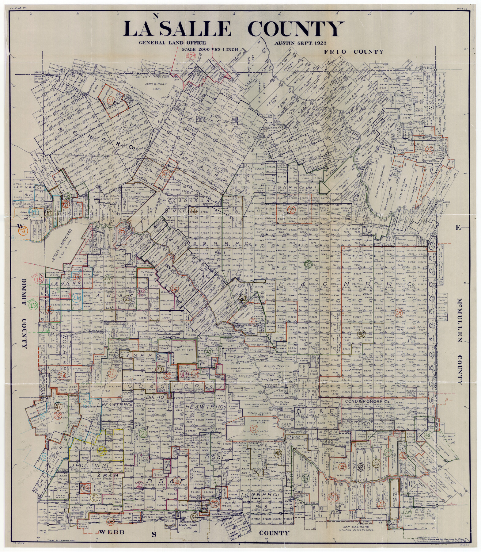
La Salle County Working Sketch Graphic Index
-
Map/Doc
76615
-
Collection
General Map Collection
-
Object Dates
9/1923 (Creation Date)
-
People and Organizations
J. Bascom Giles (Tracer)
-
Counties
La Salle
-
Subjects
County Surveying Working Sketch
-
Height x Width
48.2 x 42.0 inches
122.4 x 106.7 cm
-
Scale
1" = 2000 varas
Part of: General Map Collection
Flight Mission No. BQR-16K, Frame 32, Brazoria County

Print $20.00
- Digital $50.00
Flight Mission No. BQR-16K, Frame 32, Brazoria County
1952
Size 18.5 x 22.2 inches
Map/Doc 84099
Terry County Boundary File 5

Print $2.00
- Digital $50.00
Terry County Boundary File 5
Size 14.2 x 8.9 inches
Map/Doc 59257
Jeff Davis County Rolled Sketch 23

Print $20.00
- Digital $50.00
Jeff Davis County Rolled Sketch 23
1886
Size 24.9 x 25.4 inches
Map/Doc 7715
Geological Highway Map of Texas

Geological Highway Map of Texas
1973
Size 27.9 x 36.5 inches
Map/Doc 77523
Culberson County Working Sketch 17

Print $20.00
- Digital $50.00
Culberson County Working Sketch 17
1927
Size 22.9 x 35.2 inches
Map/Doc 68469
Bell County Sketch File 29

Print $4.00
- Digital $50.00
Bell County Sketch File 29
1874
Size 13.1 x 8.1 inches
Map/Doc 14439
Borden County Boundary File 6

Print $28.00
- Digital $50.00
Borden County Boundary File 6
1908
Size 11.3 x 25.1 inches
Map/Doc 1717

[Surveys above the San Antonio Road]
![69758, [Surveys above the San Antonio Road], General Map Collection](https://historictexasmaps.com/wmedia_w700/maps/69758.tif.jpg)
Print $2.00
- Digital $50.00
[Surveys above the San Antonio Road]
1846
Size 8.5 x 7.6 inches
Map/Doc 69758
Erath County Sketch File 28

Print $40.00
- Digital $50.00
Erath County Sketch File 28
1895
Size 16.5 x 12.0 inches
Map/Doc 22309
Goliad County Sketch File 15

Print $4.00
- Digital $50.00
Goliad County Sketch File 15
1879
Size 8.1 x 14.9 inches
Map/Doc 24245
Montgomery County Sketch File 30

Print $20.00
- Digital $50.00
Montgomery County Sketch File 30
Size 37.5 x 41.7 inches
Map/Doc 10549
You may also like

Marion County Rolled Sketch 9B

Print $20.00
- Digital $50.00
Marion County Rolled Sketch 9B
2001
Size 22.5 x 22.4 inches
Map/Doc 76420
Flight Mission No. BQY-4M, Frame 118, Harris County

Print $20.00
- Digital $50.00
Flight Mission No. BQY-4M, Frame 118, Harris County
1953
Size 18.6 x 22.3 inches
Map/Doc 85285
Nueces County Rolled Sketch 100

Print $20.00
- Digital $50.00
Nueces County Rolled Sketch 100
Size 30.6 x 40.7 inches
Map/Doc 10209
Runnels County Sketch File 36

Print $20.00
Runnels County Sketch File 36
1889
Size 20.9 x 19.6 inches
Map/Doc 12267
Kleberg County Rolled Sketch 10-43

Print $20.00
- Digital $50.00
Kleberg County Rolled Sketch 10-43
1951
Size 37.2 x 34.9 inches
Map/Doc 9395

Jefferson County Rolled Sketch 41

Print $20.00
- Digital $50.00
Jefferson County Rolled Sketch 41
1897
Size 25.1 x 17.8 inches
Map/Doc 6399
Duval County Sketch File 23

Print $4.00
- Digital $50.00
Duval County Sketch File 23
Size 8.1 x 7.1 inches
Map/Doc 21326
Montague County Working Sketch 22

Print $20.00
- Digital $50.00
Montague County Working Sketch 22
1952
Size 29.5 x 24.6 inches
Map/Doc 71088
Presidio County Rolled Sketch A-2

Print $20.00
- Digital $50.00
Presidio County Rolled Sketch A-2
1889
Size 36.9 x 43.9 inches
Map/Doc 9770
Middle Sulphur and South Sulphur Rivers, Horton Sheet

Print $20.00
- Digital $50.00
Middle Sulphur and South Sulphur Rivers, Horton Sheet
1925
Size 25.6 x 22.0 inches
Map/Doc 78330