Hudspeth County Rolled Sketch 39
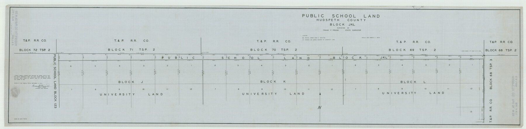
Public School Land, Hudspeth County, Block JKL
-
Map/Doc
9212
-
Collection
General Map Collection
-
Object Dates
1935/9/5 (Creation Date)
-
People and Organizations
Frank F. Friend (Surveyor/Engineer)
Eleta Foster (Draftsman)
-
Counties
Hudspeth
-
Subjects
Surveying Rolled Sketch
-
Height x Width
21.7 x 88.2 inches
55.1 x 224.0 cm
-
Medium
linen, manuscript
-
Scale
1" = 500 varas
Related maps
PSL Field Notes for Block JKL in Hudspeth County

PSL Field Notes for Block JKL in Hudspeth County
Map/Doc 81658
Part of: General Map Collection
Brewster County Sketch File C-1

Print $14.00
- Digital $50.00
Brewster County Sketch File C-1
1911
Size 11.2 x 8.9 inches
Map/Doc 15719
Live Oak County Sketch File 2

Print $4.00
- Digital $50.00
Live Oak County Sketch File 2
1856
Size 11.4 x 7.6 inches
Map/Doc 30253
Cottle County Sketch File 10

Print $20.00
- Digital $50.00
Cottle County Sketch File 10
Size 15.7 x 23.1 inches
Map/Doc 11193
Williamson County Working Sketch 18

Print $20.00
- Digital $50.00
Williamson County Working Sketch 18
1985
Size 26.1 x 26.6 inches
Map/Doc 72578
Jefferson County Aerial Photograph Index Sheet 1

Print $20.00
- Digital $50.00
Jefferson County Aerial Photograph Index Sheet 1
1953
Size 23.3 x 16.8 inches
Map/Doc 83707
Flight Mission No. DQN-6K, Frame 75, Calhoun County

Print $20.00
- Digital $50.00
Flight Mission No. DQN-6K, Frame 75, Calhoun County
1953
Size 18.6 x 22.2 inches
Map/Doc 84447
Hale County Sketch File 19

Print $4.00
- Digital $50.00
Hale County Sketch File 19
Size 8.4 x 8.8 inches
Map/Doc 24751
North Part of El Paso Co.

Print $20.00
- Digital $50.00
North Part of El Paso Co.
1977
Size 30.5 x 40.5 inches
Map/Doc 77273
Wilson County Working Sketch 14

Print $20.00
- Digital $50.00
Wilson County Working Sketch 14
1987
Size 31.9 x 36.2 inches
Map/Doc 72594
Chambers County Sketch File 50

Print $49.00
- Digital $50.00
Chambers County Sketch File 50
1917
Size 14.4 x 8.8 inches
Map/Doc 18048
Aransas County Rolled Sketch 5

Print $53.00
- Digital $50.00
Aransas County Rolled Sketch 5
1953
Size 10.5 x 15.4 inches
Map/Doc 42075
Brazoria County Sketch File 7

Print $4.00
- Digital $50.00
Brazoria County Sketch File 7
1868
Size 8.6 x 11.0 inches
Map/Doc 14932
You may also like
Oil Fields of the Texas-Louisiana Gulf Coastal Plain

Oil Fields of the Texas-Louisiana Gulf Coastal Plain
1903
Map/Doc 97518
Glasscock County Working Sketch 8

Print $40.00
- Digital $50.00
Glasscock County Working Sketch 8
1955
Size 43.5 x 120.3 inches
Map/Doc 63181
Map of the State of Texas

Print $40.00
- Digital $50.00
Map of the State of Texas
1879
Size 47.1 x 51.4 inches
Map/Doc 2133
Calcasieu Pass to Sabine Pass

Print $20.00
- Digital $50.00
Calcasieu Pass to Sabine Pass
1925
Size 44.1 x 36.0 inches
Map/Doc 69804
Presidio County Working Sketch 50

Print $20.00
- Digital $50.00
Presidio County Working Sketch 50
1953
Size 45.2 x 41.5 inches
Map/Doc 71727
[Sketch of surveys in Val Verde County]
![5048, [Sketch of surveys in Val Verde County], Maddox Collection](https://historictexasmaps.com/wmedia_w700/maps/5048.tif.jpg)
Print $20.00
- Digital $50.00
[Sketch of surveys in Val Verde County]
Size 17.3 x 17.1 inches
Map/Doc 5048
Crane County Working Sketch 28

Print $40.00
- Digital $50.00
Crane County Working Sketch 28
1972
Size 49.4 x 49.1 inches
Map/Doc 68305
[Map of the San Antonio del Encinal as Corrected]
![4459, [Map of the San Antonio del Encinal as Corrected], Maddox Collection](https://historictexasmaps.com/wmedia_w700/maps/4459.tif.jpg)
Print $20.00
- Digital $50.00
[Map of the San Antonio del Encinal as Corrected]
Size 28.5 x 30.7 inches
Map/Doc 4459
Jeff Davis County Sketch File 33

Print $40.00
- Digital $50.00
Jeff Davis County Sketch File 33
1944
Size 48.2 x 26.0 inches
Map/Doc 10507
Cameron County Rolled Sketch 13

Print $40.00
- Digital $50.00
Cameron County Rolled Sketch 13
1952
Size 37.7 x 62.7 inches
Map/Doc 61787
Shelby County Working Sketch 25

Print $20.00
- Digital $50.00
Shelby County Working Sketch 25
1948
Size 23.5 x 36.2 inches
Map/Doc 63879
Travis County Rolled Sketch 4

Print $20.00
- Digital $50.00
Travis County Rolled Sketch 4
1915
Size 19.7 x 35.6 inches
Map/Doc 8010