Colorado County Sketch File 30
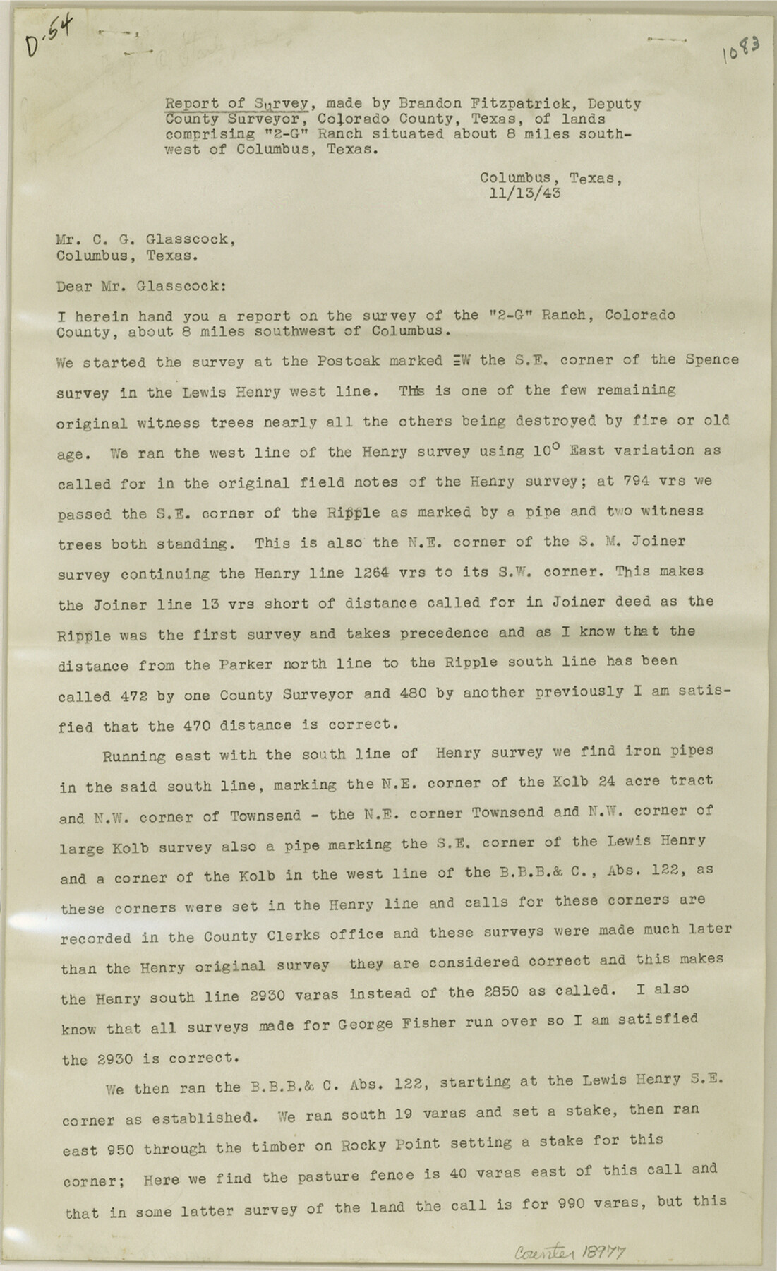
Report of survey, made by Brandon Fitzpatrick, Deputy County Surveyor, Colorado County, Texas, of lands comprising "2-G" Ranch situated about 8 miles southwest of Columbus, Texas
-
Map/Doc
18977
-
Collection
General Map Collection
-
Object Dates
1943/11/13 (Creation Date)
1943/12/6 (File Date)
-
People and Organizations
Brandon Fitzpatrick (Surveyor/Engineer)
-
Counties
Colorado
-
Subjects
Surveying Sketch File
-
Height x Width
14.1 x 8.6 inches
35.8 x 21.8 cm
-
Medium
paper, print
-
Comments
See Colorado County Rolled Sketch 3 (8641 and 8642) for sketches.
-
Features
Rocky Point
Crasco Creek
Harter Road
Speaksville Road
Related maps
Colorado County Rolled Sketch 3

Print $20.00
- Digital $50.00
Colorado County Rolled Sketch 3
1943
Size 42.4 x 38.7 inches
Map/Doc 8641
Colorado County Rolled Sketch 3

Print $20.00
- Digital $50.00
Colorado County Rolled Sketch 3
1943
Size 43.6 x 40.2 inches
Map/Doc 8642
Part of: General Map Collection
Angelina County Working Sketch 44

Print $20.00
- Digital $50.00
Angelina County Working Sketch 44
1976
Size 22.2 x 25.7 inches
Map/Doc 67127
Jackson County Aerial Photograph Index Sheet 7

Print $20.00
- Digital $50.00
Jackson County Aerial Photograph Index Sheet 7
1956
Size 21.2 x 15.8 inches
Map/Doc 83706
Medina County Working Sketch 17

Print $20.00
- Digital $50.00
Medina County Working Sketch 17
1979
Size 26.8 x 34.5 inches
Map/Doc 70932
Wharton County Sketch File 2

Print $40.00
- Digital $50.00
Wharton County Sketch File 2
1875
Size 13.6 x 12.6 inches
Map/Doc 39913
Liberty County Sketch File 54

Print $54.00
- Digital $50.00
Liberty County Sketch File 54
1889
Size 14.3 x 8.7 inches
Map/Doc 30022
Packery Channel

Print $3.00
- Digital $50.00
Packery Channel
1974
Size 10.2 x 10.3 inches
Map/Doc 3000
Dimmit County

Print $40.00
- Digital $50.00
Dimmit County
1916
Size 40.0 x 48.8 inches
Map/Doc 66806
Terrell County Working Sketch 84c

Print $20.00
- Digital $50.00
Terrell County Working Sketch 84c
1992
Size 18.2 x 31.3 inches
Map/Doc 69607
Nueces County Rolled Sketch 100

Print $20.00
- Digital $50.00
Nueces County Rolled Sketch 100
Size 43.9 x 37.7 inches
Map/Doc 10208
Cherokee County Sketch File 9

Print $8.00
- Digital $50.00
Cherokee County Sketch File 9
1853
Size 5.6 x 4.2 inches
Map/Doc 18132
Winkler County Working Sketch 7

Print $20.00
- Digital $50.00
Winkler County Working Sketch 7
1958
Size 45.4 x 30.2 inches
Map/Doc 72601
Connected Map of Austin's Colony

Print $20.00
- Digital $50.00
Connected Map of Austin's Colony
1892
Size 47.5 x 43.0 inches
Map/Doc 76074
You may also like
Amended Plat New Hobbs Addition to New Hobbs, Lea County, New Mexico

Print $20.00
- Digital $50.00
Amended Plat New Hobbs Addition to New Hobbs, Lea County, New Mexico
Size 24.1 x 18.5 inches
Map/Doc 92418


Hunt County Sketch File 35

Print $4.00
- Digital $50.00
Hunt County Sketch File 35
Size 5.3 x 8.3 inches
Map/Doc 27148
Lynn County Boundary File 7a

Print $8.00
- Digital $50.00
Lynn County Boundary File 7a
Size 14.3 x 8.8 inches
Map/Doc 56647
San Patricio County Rolled Sketch 46E

Print $20.00
- Digital $50.00
San Patricio County Rolled Sketch 46E
1983
Size 17.4 x 46.3 inches
Map/Doc 8376
Flight Mission No. BQR-13K, Frame 23, Brazoria County

Print $20.00
- Digital $50.00
Flight Mission No. BQR-13K, Frame 23, Brazoria County
1952
Size 18.9 x 22.4 inches
Map/Doc 84071
Flight Mission No. DCL-6C, Frame 115, Kenedy County

Print $20.00
- Digital $50.00
Flight Mission No. DCL-6C, Frame 115, Kenedy County
1943
Size 18.5 x 22.4 inches
Map/Doc 85945
[H. & G. N. RR. Co. Block 1]
![90890, [H. & G. N. RR. Co. Block 1], Twichell Survey Records](https://historictexasmaps.com/wmedia_w700/maps/90890-1.tif.jpg)
Print $20.00
- Digital $50.00
[H. & G. N. RR. Co. Block 1]
Size 17.1 x 28.0 inches
Map/Doc 90890
San Saba County Sketch File 1

Print $46.00
- Digital $50.00
San Saba County Sketch File 1
1854
Size 9.1 x 7.8 inches
Map/Doc 36400
Eastland County Sketch File 8

Print $8.00
- Digital $50.00
Eastland County Sketch File 8
1872
Size 12.9 x 8.1 inches
Map/Doc 21576
Flight Mission No. BQR-4K, Frame 64, Brazoria County

Print $20.00
- Digital $50.00
Flight Mission No. BQR-4K, Frame 64, Brazoria County
1952
Size 18.7 x 22.4 inches
Map/Doc 83997